
The Atherton Tableland is a fertile plateau, which is part of the Great Dividing Range in Queensland, Australia. It has very deep, rich basaltic soils and the main industry is agriculture. The principal river flowing across the plateau is the Barron River, which was dammed to form the irrigation reservoir named Lake Tinaroo.

Chillagoe is a rural town and locality in the Shire of Mareeba, Queensland, Australia. In the 2016 census the locality of Chillagoe had a population of 251 people.

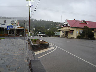
Atherton is a rural town and locality in the Tablelands Region, Queensland, Australia. In the 2016 census, Atherton had a population of 7,331 people.

Kuranda is a rural town and locality on the Atherton Tableland in the Shire of Mareeba, Queensland, Australia. In the 2016 census, Kuranda had a population of 3,008 people. It is 25 kilometres (16 mi) from Cairns, via the Kuranda Range road. It is surrounded by tropical rainforest and adjacent to the Wet Tropics of Queensland World Heritage listed Barron Gorge National Park.
Herberton is a rural town and locality in the Tablelands Region, Queensland, Australia. In the 2016 census, the locality of Herberton had a population of 855 people.

Mount Garnet is a rural town and locality in the Tablelands Region, Queensland, Australia. In the 2016 census, Mount Garnet had a population of 430 people.

The Savannahlander is an Australian passenger train service that operates in Far North Queensland. It travels on the Tablelands railway line and the Etheridge railway line from the coastal city of Cairns to Forsayth.

The Shire of Mareeba is a local government area at the base of Cape York Peninsula in Far North Queensland, inland from Cairns. The shire, administered from the town of Mareeba, covered an area of 53,491 square kilometres (20,653.0 sq mi), and existed as a local government entity from 1879 until 2008, when it amalgamated with several councils in the Atherton Tableland area to become the Tablelands Region.
The Shire of Eacham was a local government area of Queensland. It was located on the Atherton Tableland, a plateau forming part of the Great Dividing Range west of the city of Cairns. The shire, administered from the town of Malanda, covered an area of 1,126.4 square kilometres (434.9 sq mi), and existed as a local government entity from 1910 until 2008, when it amalgamated with several other councils in the Tableland area to become the Tablelands Region.

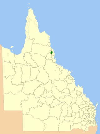
The Tablelands Region is a local government area in Far North Queensland, Australia inland from the city of Cairns. Established in 2008, it was preceded by four previous local government areas which dated back more than a century. On 1 January 2014, one of those local government areas, the Shire of Mareeba, was re-established independent of the Tablelands Region.
The Chillagoe Railway and Mining Company was an Australian business established in 1897 initially under the name Chillagoe Proprietary. Its initial purpose was to build a railway to the town of Chillagoe, Queensland to support the development of mining. In 1898, the company was recapitalised as the Chillagoe Railway and Mining Company.

Lappa is a former railway town on the western side of the Atherton Tablelands near Petford in the Shire of Mareeba in Far North Queensland, Australia.

The Cairns-to-Kuranda Railway is a heritage-listed railway line from the Cairns Region to the Shire of Mareeba, both in Queensland, Australia. It commences at Redlynch, a suburb of Cairns and travels up the Great Dividing Range to Kuranda within the Shire of Mareeba on the Atherton Tableland. It was built from 1913 to 1915 by Queensland Railways. Components of it include Stoney Creek Bridge, the Rail Bridge over Christmas Creek, Kuranda railway station, and Surprise Creek Rail Bridge. It was added to the Queensland Heritage Register on 21 August 1992. The railway is used to operate a tourist rail service, the Kuranda Scenic Railway. It forms part of the Tablelands railway line.

Stannary Hills Tramways are a heritage-listed pair of tramways at Irvinebank, Shire of Mareeba, Queensland, Australia. It was built from 1901 to 1907. It was added to the Queensland Heritage Register on 25 February 2005.

Station Master's Residence is a heritage-listed detached house at Railway Reserve, Einasleigh, Shire of Etheridge, Queensland, Australia. It was built c. 1909. It was added to the Queensland Heritage Register on 21 October 1992.
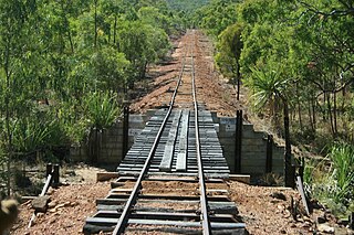
The Etheridge railway line is a heritage-listed railway line between Mount Surprise and Forsayth, both in the Shire of Etheridge, Queensland, Australia. It includes Mount Surprise railway station, Einasleigh railway station, Wirra Wirra railway station and Forsayth railway station. Etheridge railway line was added to the Queensland Heritage Register on 16 February 2009.

Almaden is a rural town and locality in the Shire of Mareeba, Queensland, Australia. In the 2016 census, the locality of Almaden had a population of 71 people.
Station Master's Residence is a heritage-listed detached house at Fourth Street, Forsayth, Shire of Etheridge, Queensland, Australia. It was built c. 1910. It was added to the Queensland Heritage Register on 21 October 1992.

Petford is a rural locality in the Shire of Mareeba, Queensland, Australia. In the 2021 census, Petford had a population of 22 people.
Tumoulin is a rural town and locality in the Tablelands Region, Queensland, Australia. In the 2016 census, Tumoulin had a population of 109 people.
 Works train in the Barron Gorge section ~1911
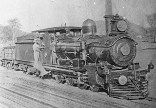
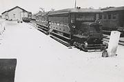 RM 34 at Mareeba, 1942
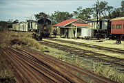 Trains crossing at Lappa on the Mungana line, September 1989
 Stannary Hill tramway, Eureka Creek valley, 1902
 Irvinebank Tramway station ~1909
 Steam tram crossing Irvinebank bridge over Gibbs Creek ~1911. Locomotive is called Baby and is on a picnic tour to Stannary Hills. (Description supplied with photograph).


