Taman Free School

Last updated
Taman Free School
Neighbourhood of George Town
Other transcription(s)
   Mandarin 大英义园(Simplified)
大英義園(Traditional)
Dà yīng yì yuán(Pinyin)
Taman Free School at Batu Lanchang, George Town, Penang.jpg
Taman Free School
Location map of George Town 2023 (city centre shown).svg
Red pog.svg
Taman Free School
Location within    George Town in    Penang
Coordinates: 5°24′13.8954″N100°18′34.9554″E / 5.403859833°N 100.309709833°E / 5.403859833; 100.309709833
Country Flag of Malaysia.svg  Malaysia
State Flag of Penang (Malaysia).svg  Penang
City Seal of George Town.svg George Town
Government
   Local government Penang Island City Council
   Mayor of Penang Island Rajendran P. Anthony
   Datok Keramat State Assemblyman Jagdeep Singh Deo (DAP)
   Jelutong Member of Parliament RSN Rayer (DAP)
Time zone UTC+8 (MST)
  Summer (DST)Not observed
Postal code
10460
Website mbpp.gov.my

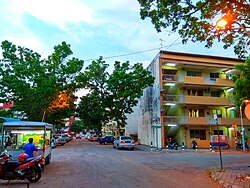
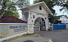
Taman Free School is a residential neighbourhood within the downtown core of George Town in the Malaysian state of Penang. It is named after the nearby Penang Free School.

Contents

History

Penang Free School, Southeast Asia's oldest English school, is situated to the west of Taman Free School. Cmglee Penang Free School main gate.jpg
Penang Free School, Southeast Asia's oldest English school, is situated to the west of Taman Free School.

Taman Free School mainly consists of low- and medium-cost flats and apartments, which were built in the 1970s. [1] [2] Each of the walk-up apartments is five-stories high and was not equipped with lifts at the time of construction. [2] In recent years, proposals have been made to rejuvenate the area, which entails the improvement of public facilities and the construction of newer apartments to lower maintenance costs. [3]

Transportation

Taman Free School is bounded by Jalan P. Ramlee to the north, Free School Road to the south and Jalan Trengganu to the west. The neighbourhood is served by Rapid Penang's bus route 206, which includes stops along the aforementioned roads, and links the neighbourhood with the city centre, Green Lane and Gelugor. [4]

Education

Heng Ee High School is situated across Free School Road. Bangunan Wawasan Heng Ee.jpg
Heng Ee High School is situated across Free School Road.

The neighbourhood is served by two adjacent high schools, namely Penang Free School and Heng Ee High School.

See also

Related Research Articles

<span class="mw-page-title-main">Wangsa Maju</span> Township in Federal Territory of Kuala Lumpur, Malaysia

Wangsa Maju is a township and a constituency in Kuala Lumpur, Malaysia. This area is surrounded by Setapak, Taman Melati and Gombak district in Selangor. Wangsa Maju is one of the major suburbs in Kuala Lumpur.

<span class="mw-page-title-main">Setia Alam</span> Township in Shah Alam

Setia Alam is a township located in Shah Alam, Selangor, Malaysia. It is accessible via Setia Alam Highway from the New Klang Valley Expressway (NKVE) since the interchange was opened on 14 July 2006. Setia Alam is also accessible from the Federal Highway and Klang via Jalan Meru. This township is developed by S P Setia Berhad.

<span class="mw-page-title-main">Sungai Dua</span> Neighbourhood of George Town in Penang, Malaysia

Sungai Dua is a residential neighbourhood within the city of George Town in the Malaysian state of Penang. Located 8.7 km (5.4 mi) south of the city centre, this neighbourhood borders Universiti Sains Malaysia to the north, Sungai Nibong to the east and Bukit Jambul to the west.

<span class="mw-page-title-main">Perai</span> Suburb of Seberang Perai in Penang, Malaysia

Perai is a suburb of Seberang Perai in the Malaysian state of Penang. It lies at the southern bank of the Perai River and borders Butterworth to the north.

<span class="mw-page-title-main">Batu Maung</span> Neighbourhood of George Town in Penang, Malaysia

Batu Maung is a residential neighbourhood in the Malaysian state of Penang. It is located 15.7 km (9.8 mi) south of the city centre, adjacent to Bayan Lepas and the Penang International Airport. Batu Maung is home to the island terminus of the Second Penang Bridge and the southern end of the Tun Dr Lim Chong Eu Expressway. It is also surrounded by fishing villages such as Permatang Damar Laut and Teluk Tempoyak.

<span class="mw-page-title-main">Tanjong Bungah</span> Suburb of George Town in Penang, Malaysia

Tanjong Bungah is a suburb of George Town in the Malaysian state of Penang. It is located along the northern coast of Penang Island between Batu Ferringhi and Tanjong Tokong, about 6.5 km (4.0 mi) northwest of the city centre.

<span class="mw-page-title-main">Gelugor</span> Suburb of George Town in Penang, Malaysia

Gelugor is a suburb of George Town in the Malaysian state of Penang. Named after a plant species, Gelugor lies along the eastern seaboard of Penang Island, between Jelutong and Sungai Dua, and nearly 5 km (3.1 mi) south of the city centre.

<span class="mw-page-title-main">Sungai Ara</span> Neighbourhood of George Town in Southwest Penang Island, Penang, Malaysia

Sungai Ara is a residential neighbourhood within the city of George Town in the Malaysian state of Penang. Located 11.9 km (7.4 mi) south of the city centre, it lies between Relau, Bayan Baru and Bayan Lepas.

<span class="mw-page-title-main">Relau</span> Suburb of George Town in Penang, Malaysia

Relau is a suburb of George Town in the Malaysian state of Penang. It is located 9.9 km (6.2 mi) southwest of the city centre, between Paya Terubong to the north, Bayan Lepas to the east and Balik Pulau to the west.

<span class="mw-page-title-main">Bukit Jambul</span> Neighbourhood of George Town in Penang, Malaysia

Bukit Jambul is a neighbourhood of George Town in the Malaysian state of Penang. Located 9.9 km (6.2 mi) south of the city centre, Bukit Jambul lies within the suburb of Paya Terubong, between Relau, Bayan Baru, Sungai Dua and Sungai Nibong.

<span class="mw-page-title-main">Batu Lanchang</span> Neighbourhood of George Town in Penang, Malaysia

Batu Lanchang is a residential neighbourhood within the downtown core of George Town in the Malaysian state of Penang. It is sandwiched between Farlim to the west and Jelutong to the east.

<span class="mw-page-title-main">Green Lane, George Town</span> Road in George Town, Penang, Malaysia

Green Lane is a major thoroughfare within the suburb of Batu Lanchang near George Town in Penang, Malaysia. Part of Penang Middle Ring Road, Green Lane starts from the intersection with Scotland Road and Air Itam Road, and stretches southwards to the Udini Roundabout within the Gelugor suburb.

<span class="mw-page-title-main">Mount Erskine</span> Neighbourhood of George Town in Penang, Malaysia

Mount Erskine is a residential neighbourhood within the city of George Town in the Malaysian state of Penang. This hilly neighbourhood is located 4 km (2.5 mi) northwest of the city centre, between Tanjung Tokong and Pulau Tikus.

<span class="mw-page-title-main">Minden Heights</span> Neighbourhood of George Town in Penang, Malaysia

Minden Heights is a residential neighbourhood within the city of George Town in the Malaysian state of Penang. Located 6.1 km (3.8 mi) south of the city centre, this upscale housing estate lies within the Gelugor suburb and neighbours Universiti Sains Malaysia to the south, as well as Taman Tun Sardon to the north.

<span class="mw-page-title-main">Taman Tun Sardon</span> Neighbourhood of George Town in Penang, Malaysia

Taman Tun Sardon is a residential neighbourhood within the city of George Town in the Malaysian state of Penang. Located 5.7 km (3.5 mi) south of the city centre, this working-class neighbourhood, which neighbours Minden Heights to the south and consists of low-cost five storey flats, was created in the 1980s and forms part of the Gelugor suburb. In all, 22 housing blocks were constructed within the neighbourhood to cater to the needs of lower-income citizens.

<span class="mw-page-title-main">Sungai Nibong</span> Neighbourhood of George Town in Penang, Malaysia

Sungai Nibong is a residential neighbourhood within the city of George Town in the Malaysian state of Penang. It lies near the eastern coast of Penang Island, about 8.6 km (5.3 mi) south of the city centre.

<span class="mw-page-title-main">Pantai Jerejak (state constituency)</span> State constituency in Penang, Malaysia

Pantai Jerejak is a state constituency in Penang, Malaysia, that has been represented in the Penang State Legislative Assembly since 2004. It covers a portion of southeastern Penang Island, including Bayan Baru and the northern half of the Bayan Lepas Free Industrial Zone.

<span class="mw-page-title-main">Batu Lancang (state constituency)</span> State constituency in Penang, Malaysia

Batu Lancang is a state constituency in Penang, Malaysia, that has been represented in the Penang State Legislative Assembly since 2004. It covers two of George Town's suburbs - Batu Lanchang and parts of Jelutong.

<span class="mw-page-title-main">Rifle Range, Penang</span> Neighbourhood of George Town in Penang, Malaysia

Rifle Range is a residential neighbourhood within the city of George Town in the Malaysian state of Penang. Located 4.4 km (2.7 mi) west of the city centre, the area was once home to a shooting range used by the British Army. The Malaysian federal government constructed nine blocks of low-cost public housing at the area in 1969, making them the first residential high-rises in Penang.

<span class="mw-page-title-main">Ayer Rajah, Penang</span> Neighbourhood of George Town in Penang, Malaysia

Ayer Rajah is a residential neighbourhood within the downtown core of George Town in the Malaysian state of Penang. This leafy, affluent neighbourhood, situated adjacent to the Penang Botanic Gardens, mostly consists of landed properties such as bungalows and semi-detached houses, surrounded by tree-lined avenues.

References

  1. "Review for Taman Free School, Green Lane". PropSocial. Retrieved 2018-04-29.
  2. 1 2 "Property Review for Taman Free School Apartment | Propwall Malaysia". www.propwall.my. Retrieved 2018-04-29.
  3. Ngui, Aaron (November 22, 2015). "Taman Free School Flats slated for pilot project in 2016". The Sun Daily. Retrieved April 29, 2018.
  4. Route map rapidpg.com.my