
Penang is a Malaysian state located on the northwest coast of Peninsular Malaysia along the Strait of Malacca. It has two parts: Penang Island, where the capital city, George Town, is located, and Seberang Perai on the Malay Peninsula. These two halves are physically connected by the Penang Bridge and the Second Penang Bridge. The state shares borders with Kedah to the north and east, and Perak to the south.

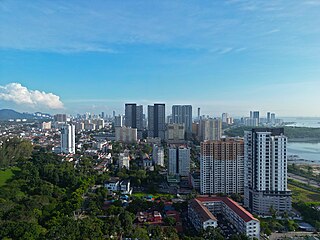
George Town is the capital of the Malaysian state of Penang. It is the core city of the George Town Conurbation, Malaysia's second largest metropolitan area with a population of 2.84 million and the second largest metropolitan economy in the country. The city proper spans an area of 306 km2 (118 sq mi) encompassing Penang Island and surrounding islets, and had a population of 794,313 as of 2020.

Seberang Perai is a city in the Malaysian state of Penang. Located on the Malay Peninsula and separated from Penang Island by the Penang Strait, it shares borders with Kedah to the north and east and Perak to the south. The city spans an area of 748 km2 (289 sq mi) and had a population of 946,092 as of 2020, making it the third largest city in Malaysia.

Penang Island is the main constituent island of the Malaysian state of Penang. It is located off the western coast of Peninsular Malaysia by the Malacca Strait, with the Penang Strait separating the island from Seberang Perai on the mainland. The 295 km2 (114 sq mi) island makes up approximately 28% of Penang's total land mass and is home to about 45% of the state's population as of 2020. The entire island falls under the city of George Town, which also administers the surrounding islets.
Malaysian national projects are major national projects that are important to the development of Malaysia. The following is a list from Malaysian independence in 1957 to the present.

Gelugor is a suburb of George Town in the Malaysian state of Penang. Named after a plant species, Gelugor lies along the eastern seaboard of Penang Island, between Jelutong and Sungai Dua, and nearly 5 km (3.1 mi) south of the city centre.
Jelutong is a suburb of George Town in the Malaysian state of Penang. Located 3.2 km (2.0 mi) south of the city centre, Jelutong has been inhabited since as early as the late 18th century, when traders from Aceh and India settled around the area.
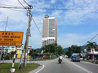
Teluk Kumbar is a suburb of George Town in the Malaysian state of Penang. It is located about 17.8 km (11.1 mi) south of the city centre, at the southern coast of Penang Island between Bayan Lepas to the east and Gertak Sanggul to the west.

As the core of Malaysia's second largest conurbation, Penang has a relatively developed transport infrastructure. The state is well-connected by land, air and sea. The Penang International Airport is Malaysia's third busiest by passenger traffic and the busiest by export volume, while the Port of Penang is the main transshipment hub of northern Malaysia. The island city of George Town is physically connected to mainland Seberang Perai by two road bridges and the oldest ferry service in the country. The North–South Expressway and Keretapi Tanah Melayu's west coast line – two major arteries along western Peninsular Malaysia – run through the state.

Farlim, officially Bandar Baru Ayer Itam, is a residential neighbourhood within the city of George Town in the Malaysian state of Penang. Located 6 km (3.7 mi) southwest of the city centre, the township was created in the 1980s. Over the recent decades, Farlim has witnessed rapid development with several residential and commercial developments within the area.

Sri Permaisuri is a township in Cheras, Kuala Lumpur, Malaysia. It is located near Bandar Tun Razak and Salak South. It was opened for residential housing in 2000. The major types of housing there are apartments and condominiums.

The Greater Penang Conurbation, also known as the George Town Conurbation, is the urban area within and surrounding the Malaysian state of Penang, including parts of neighbouring Kedah and Perak. It is the second largest conurbation in Malaysia, with a population of over 2.84 million as of 2020. The conurbation is also the second largest metropolitan economy in the country after the Klang Valley, with an estimated gross domestic product (GDP) of over US$30 billion in 2020.

Karpal Singh Drive is a seafront promenade in George Town within the Malaysian state of Penang. Located at Bandar Sri Pinang, it faces the Penang Strait and was named after Karpal Singh (1940-2014), a prominent opposition politician and lawyer who hailed from the city.
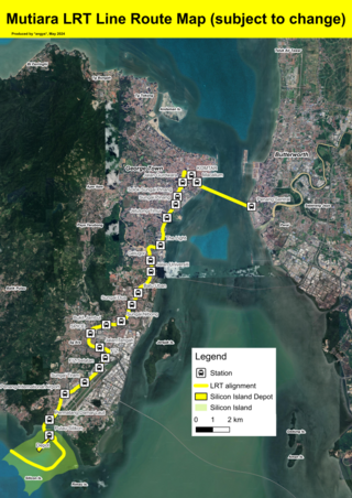
The Mutiara LRT Line is a light rail transit (LRT) system under development in Penang. The 29.5 km (18.3 mi) line will connect George Town's city centre with its southern suburbs of Jelutong, Gelugor and Bayan Lepas, with a link towards Seberang Perai across the Penang Strait. The first domestic LRT line outside the Klang Valley, the Mutiara line is a component of the Penang Transport Master Plan (PTMP) and comprises 21 stations. Once completed, it will be owned by the Mass Rapid Transit Corporation. Construction of the line began in 2025 and will be completed by 2031.

Gurney Bay, formerly known as Gurney Wharf, is a seafront park within George Town in the Malaysian state of Penang. Intended as a "new iconic waterfront destination for Penang", the first phase of this public space off Gurney Drive was opened to public in 2024.

The Pinang River is a river that runs through the city of George Town within the Malaysian state of Penang. Stretching for approximately 3.5 kilometres, the river cuts through the city centre, passing under the Tun Dr Lim Chong Eu Expressway before emptying into the Penang Strait.
The Penang Transport Master Plan is a strategic initiative developed by the Penang state government between 2012 and 2015, aimed at creating an integrated transportation system across the state. The multimodal plan, with an original estimated cost of RM27 billion, includes the introduction of urban rail lines and the construction of additional expressways to address the growing population density in Penang. As of 2025, some elements of the master plan are being implemented, including the Mutiara LRT and the Ayer Itam–Tun Dr Lim Chong Eu Expressway Bypass.

Central George Town is the city centre of George Town, the capital of the Malaysian state of Penang. It corresponds to the eponymous subdivision of George Town, which is mostly identical to the original city limits established when George Town was granted city status in 1957.

The Bandar Sri Pinang station is a future elevated light rail transit station on the Mutiara line in George Town, Penang. It is situated at Bandar Sri Pinang, along the Tun Dr Lim Chong Eu Expressway.

The Light Waterfront is a residential neighbourhood within the city of George Town in the Malaysian state of Penang. Situated within the city centre, it encompasses the foreshore north of the Penang Bridge and is bounded by the Tun Dr Lim Chong Eu Expressway to its west. Comprising a mix of residential, commercial and recreational developments, the township is being built through land reclamation by Malaysian conglomerate IJM Corporation.


