Penang is a Malaysian state located on the northwest coast of Peninsular Malaysia along the Strait of Malacca. It has two parts: Penang Island, where the capital city, George Town, is located, and Seberang Perai on the Malay Peninsula. These two halves are physically connected by the Penang Bridge and the Second Penang Bridge. The state shares borders with Kedah to the north and east, and Perak to the south.

Butterworth is the city centre of Seberang Perai in the Malaysian state of Penang. It lies about 3 km (1.9 mi) east of George Town, the capital city of Penang, across the Penang Strait. As of 2020, Butterworth had a total population of 80,378 residents.
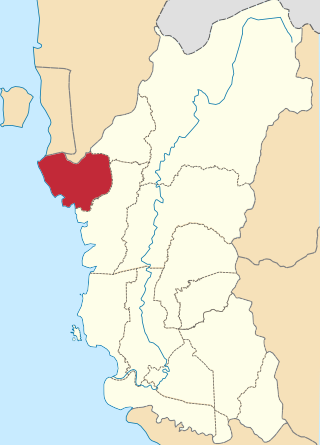
The Kerian District is an administrative district in Perak, Malaysia. It covers the northwestern corner of Perak, bordering the states of Penang and Kedah to the north; the main town of Parit Buntar is located a mere 37 km (23 mi) southeast of George Town, Penang's capital city. The district is well known for Bukit Merah, a popular tourist destination.
Seberang Perai is a city in the Malaysian state of Penang. Located on the Malay Peninsula and separated from Penang Island by the Penang Strait, it shares borders with Kedah to the north and east and Perak to the south. The city spans an area of 748 km2 (289 sq mi) and had a population of 946,092 as of 2020, making it the third largest city in Malaysia.

The North–South Expressway Northern Route is an interstate controlled-access highway running parallel to the northwestern coast of Peninsular Malaysia. The 460-kilometre (290-mile) expressway forms the north section of the North–South Expressway, passing through the northwestern states of Kedah, Penang, Perak and Selangor. The expressway begins at the Bukit Kayu Hitam checkpoint in Kedah, where the Malaysia–Thailand border lies, and ends at Bukit Lanjan in Selangor state where the expressway interchanges with the New Klang Valley Expressway. The expressway is operated by PLUS Expressways.

Bukit Mertajam is a suburb of Seberang Perai in the Malaysian state of Penang. It also serves as the seat of the Central Seberang Perai District. As of 2020, Bukit Mertajam had a population of 12,079.

Nibong Tebal is a suburb of Seberang Perai in the Malaysian state of Penang. Located at the northern bank of the Kerian River within the Southern Seberang Perai District, it is the southernmost populated place of Penang. Nibong Tebal contained a population of 1,425 as of 2020.

Perai is a suburb of Seberang Perai in the Malaysian state of Penang. It lies at the southern bank of the Perai River and borders Butterworth to the north.

Parit Buntar is a town in Kerian District, Perak, Malaysia. It is bordering to Nibong Tebal in Penang and Bandar Baharu in Kedah.It is also the district capital of Kerian District.

The Bandar Baharu District is a district containing a town of the same name and a state assembly constituency at the southernmost end of Kedah, Malaysia. The Bandar Baharu District is located along the Kedah-Penang-Perak border tripoint, 37 km (23 mi) southeast of George Town, Penang's capital city.

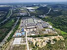
Seberang Jaya is a suburb of Seberang Perai in the Malaysian state of Penang. Located at the southern bank of the Perai River and east of Perai proper, the area was developed in the 1970s. Since then, Seberang Jaya has evolved into a booming area, with various commercial and retail developments.

Bagan Serai is a mukim in Kerian District, Perak, Malaysia. It is located 52 km (32 mi) southeast of George Town, the capital city of the neighbouring state of Penang. As such, the town is also part of Greater Penang, Malaysia's second largest conurbation, with the town's logistical needs being served by Penang's well-developed transportation infrastructure. There is the birthplace of the No.1 badminton player, Lee Chong Wei.

As the core of Malaysia's second largest conurbation, Penang has a relatively developed transport infrastructure. The state is well-connected by land, air and sea. The Penang International Airport is Malaysia's third busiest by passenger traffic and the busiest by export volume, while the Port of Penang is the main transshipment hub of northern Malaysia. The island city of George Town is physically connected to mainland Seberang Perai by two road bridges and the oldest ferry service in the country. The North–South Expressway and Keretapi Tanah Melayu's west coast line – two major arteries along western Peninsular Malaysia – run through the state.

The Roman Catholic Diocese of Penang is situated in the northern as well as the east coast region of Peninsular Malaysia covering 4 northern states, namely Perlis, Kedah, Penang and Perak as well as the east coast state of Kelantan. It was created on 25 February 1955 together with the Archdiocese of Kuala Lumpur. It is under the ecclesiastical province of Kuala Lumpur.
The Seberang Perai City Council is the local government that administers the city of Seberang Perai, which encompasses the mainland half of the Malaysian state of Penang. The city council, which has jurisdiction over an area of 748 km2 (289 sq mi), falls under the purview of the Penang state government.
Tasek Gelugor is a suburb of Seberang Perai in the Malaysian state of Penang. Within its vicinity it is the town closest to the North–South Expressway. The expressway sign for the Ipoh-George Town link can be seen in this town.

Mengkuang Titi is a village within the city of Seberang Perai in the Malaysian state of Penang. It is located not too far from the Mengkuang Dam. The village has a population of about 800, and still retains the rustic feel ideal for the development of agricultural and cottage industries.

Capital FM was a Malaysian radio station which began broadcasting in 2008. Throughout the station's lifetime, it went through two phases, as an urban radio station and as a women-oriented radio station.