Tarawera River

Last updated
Tarawera River
Tarawera River.jpg
Tarawera River on the Rangitaiki Plains
Tarawera River
Approximate course Tarawera River (dark blue).
Location
Country New Zealand
Physical characteristics
Mouth  
  location
Bay of Plenty
Length65 km (40 mi)
Basin size906 km2 (350 sq mi) (measured up to Awakaponga)
Discharge 
  average26 m3/s (920 cu ft/s)

The Tarawera River is in the Bay of Plenty Region in the North Island of New Zealand.

Contents

It flows from Lake Tarawera, northeastwards across the northern flanks of the active volcano Mount Tarawera, and past the town of Kawerau before turning north, reaching the Bay of Plenty 6 kilometres (4 mi) west of Edgecumbe.

The Tarawera Falls on the river are considered to be quite spectacular.

Upper Tarawera River. Tarawera River, overhanging branches.jpg
Upper Tarawera River.
Tarawera Falls on a misty high flow day. Tarawerafalls.jpg
Tarawera Falls on a misty high flow day.
Easterly view across Tarawera River in its flood plain towards Putauaki. Putauaki Tarawera.jpg
Easterly view across Tarawera River in its flood plain towards Putauaki.

Environmental issues

The Tasman Pulp and Paper Mill, now owned by Norske Skog, has been discharging waste into the river since 1955. [1] Local residents have erected signposts labelling the river as the "Black Drain" since the 1990s. [2]

The dark colour is due to the presence of pollution from farms, sewage and stormwater but it is predominantly from pulp and paper mill effluent. As of 1997, pulp and paper mills were discharging over 160 million litres of industrial waste into the river per day. [3] By 2006, the oxygen levels in the river had reached a level where fish could survive, however the water colour was still dark. Since 1998 the colour and light penetration (euphotic depth) have improved in the lower section of the river due to less pollution from the Tasman Mill. [2]

In 2009, the mill gained permission to continue polluting the river for the next 25 years. [4] In 2010, local iwi took a case to the High Court to shorten the 25 year water discharge permits issued under the Resource Management Act but the appeal was rejected. [1]

Geology

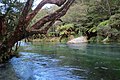
The Tarawera River drains the north-eastern aspect of the Taupō Rift with its river mouth west of Matata. The river commences at the north-east arm of Lake Tarawera with a mean outflow of 7 m3/s (250 cu ft/s), [5] :491 from effectively a watershed of the Ōkataina Caldera, with its risk of volcanic activity disrupting river flow. At this normal or less flow the river disappears underground into caves in the rhyolite lava flow just before the Tarawera Falls. [5] :491 [6] It usually emerges about half way up the full falls drop, [6] but can with recent rain fully occupy the drop. There have been two known major floods following the breakdown of temporary volcanic material dams at the lake outlet. [5]

The first, and larger, followed the 1314 ± 12 CE [7] :4 Kaharoa eruption. [5] :491–2 The present river start is where the Tapahoro lava flow, created by the 5526 ± 145 BP [7] :4 Whakatane eruption, [5] :492 runs into a 14,009 ± 155 BP [7] Pokohu lava flow. The Tarawera River flows across this in a 10 m (33 ft) wide channel. [5] :492. The 1314 eruption blocked the outlet with a temporary dam up to 32 m (105 ft) above present outlet levels, which was subsequently eroded with a great flood that created a 350 m (1,150 ft) wide, and almost 40 m (130 ft) deep valley spillway at the start of the river. [5] :497 It seems the river during this flood overflowed to the east draining for a time through the Awiti Ravine, and back into the Tarawera River flood plain by the present Waiaute Stream that drains the eastern slopes of Mount Tarawera. [5] :500 However it also evacuated 3 km (1.9 mi) downstream from the lake at the terminus of the Pokohu lava flow the amphitheatre of the Tarawera Falls. [5] :500 The flood deposited large boulders up to 20 m (66 ft) in diameter for 1 km (0.62 mi) below the falls and up to 13 m (43 ft) to 8 km (5.0 mi) below the falls. [5] :497

The lake outlet was blocked again after the 1886 eruption of Mount Tarawera, and the lake level increased to a maximum of 12.8 m (42 ft) above its present level. [5] :491–2,4 This volcanic debris dam (the debris that blocked the outlet were not just from the eruption directly but included those washed down from a creek that runs into the lake by the outlet), first broke on 1 November 1904, with a main flood surge on 3 November 1904 which was assessed at a peak flow of 700 m3/s (25,000 cu ft/s). [5] :504. This flood resulted in the raising of the river bed (aggradation), and sedimentation problems to 50 km (31 mi) downstream of the lake. [5] :504

Related Research Articles

<span class="mw-page-title-main">Lake Taupō</span> New Zealands largest lake

Lake Taupō is a large crater lake in New Zealand's North Island, located in the caldera of Taupō Volcano. The lake is the namesake of the town of Taupō, which sits on a bay in the lake's northeastern shore. With a surface area of 616 km2 (238 sq mi), it is the largest lake by surface area in New Zealand, and the second largest freshwater lake by surface area in geopolitical Oceania after Lake Murray in Papua New Guinea. Motutaiko Island lies in the southeastern area of the lake.

<span class="mw-page-title-main">Taupō Volcanic Zone</span> Active volcanic zone in New Zealand

The Taupō Volcanic Zone (TVZ) is a volcanic area in the North Island of New Zealand that has been active for the past two million years and is still highly active. Mount Ruapehu marks its south-western end and the zone runs north-eastward through the Taupō and Rotorua areas and offshore into the Bay of Plenty. It is part of the larger Central Volcanic Region that extends further westward through the western Bay of Plenty to the eastern side of the Coromandel Peninsula and has been active for four million years. At Taupō the rift volcanic zone is widening east–west at the rate of about 8 mm per year while at Mount Ruapehu it is only 2–4 mm per year but this increases at the north eastern end at the Bay of Plenty coast to 10–15 mm per year. It is named after Lake Taupō, the flooded caldera of the largest volcano in the zone, the Taupō Volcano and contains a large central volcanic plateau as well as other landforms associated with its containing tectonic intra-arc continental Taupō Rift.

<span class="mw-page-title-main">Mount Tarawera</span> Volcano in New Zealand

Mount Tarawera is a volcano on the North Island of New Zealand within the older but volcanically productive Ōkataina Caldera. Located 24 kilometres southeast of Rotorua, it consists of a series of rhyolitic lava domes that were fissured down the middle by an explosive basaltic eruption in 1886. While the 1886 eruption was basaltic, study has shown there was only a small basalt component to the previous recent rhyolitic predominant eruptions. This eruption was one of New Zealand's largest historical eruptions, and killed an estimated 120 people. The fissures run for about 17 kilometres (11 mi) northeast–southwest

<span class="mw-page-title-main">Te Wairoa, New Zealand</span> Ghost town in Bay of Plenty, New Zealand

Te Wairoa was a village close to the shore of Lake Tarawera near Rotorua, New Zealand. The village was buried by volcanic ash in the 1886 eruption of Mount Tarawera. It was later excavated and is now open as a tourist destination, the Buried Village.

<span class="mw-page-title-main">Lake Rotomahana</span> Lake in the North Island of New Zealand

Lake Rotomahana is an 800-hectare (2,000-acre) lake in northern New Zealand, located 20 kilometres to the south-east of Rotorua. It is immediately south-west of the dormant volcano Mount Tarawera, and its geography was substantially altered by a major 1886 eruption of Mount Tarawera. Along with the mountain, it lies within the Okataina caldera. It is the most recently formed larger natural lake in New Zealand, and the deepest in the Rotorua district.

<span class="mw-page-title-main">Lake Tarawera</span> Lake in New Zealand

Lake Tarawera is the largest of a series of lakes which surround the volcano Mount Tarawera in the North Island of New Zealand. Like the mountain, it lies within the Ōkataina Caldera. It is located 18 kilometres (11 mi) to the east of Rotorua, and beneath the peaks of the Tarawera massif i.e. Wahanga, Ruawahia, Tarawera and Koa. The lake's surface area is 39 square kilometres (15 sq mi).

<span class="mw-page-title-main">Rangitaiki River</span> River in New Zealand

The Rangitaiki River is the longest river in the Bay of Plenty region in New Zealand's North Island. It is 155 kilometres (96 mi) long, and rises inland from northern Hawkes Bay to the east of the Kaingaroa Forest. The Rangitaiki catchment covers an area of 3005 km2. It flows in a generally northeastward direction, passing through the town of Murupara and skirting close to the western edge of Te Urewera National Park before turning northwards, flowing past Edgecumbe and into the Bay of Plenty close to Thornton.

<span class="mw-page-title-main">Tarawera Falls</span> Waterfall in Bay of Plenty, New Zealand


Tarawera Falls is a 65 m high waterfall on the Tarawera River in the Bay of Plenty region in New Zealand's North Island.

<span class="mw-page-title-main">Hatepe eruption</span> Major eruption of Taupō volcano

The Hatepe eruption, named for the Hatepe Plinian pumice tephra layer, sometimes referred to as the Taupō eruption or Horomatangi Reef Unit Y eruption, is dated to 232 CE ± 10 and was Taupō Volcano's most recent major eruption. It is thought to be New Zealand's largest eruption within the last 20,000 years. The eruption ejected some 45–105 km3 (11–25 cu mi) of bulk tephra, of which just over 30 km3 (7.2 cu mi) was ejected in approximately 6–7 minutes. This makes it one of the largest eruptions in the last 5,000 years, comparable to the Minoan eruption in the 2nd millennium BCE, the 946 eruption of Paektu Mountain, the 1257 eruption of Mount Samalas, and the 1815 eruption of Mount Tambora.

<span class="mw-page-title-main">Volcanic dam</span> Natural dam produced directly or indirectly by volcanism

A volcanic dam is a type of natural dam produced directly or indirectly by volcanism, which holds or temporarily restricts the flow of surface water in existing streams, like a man-made dam. There are two main types of volcanic dams, those created by the flow of molten lava, and those created by the primary or secondary deposition of pyroclastic material and debris. This classification generally excludes other, often larger and longer lived dam-type geologic features, separately termed crater lakes, although these volcanic centers may be associated with the source of material for volcanic dams, and the lowest portion of its confining rim may be considered as such a dam, especially if the lake level within the crater is relatively high.

<span class="mw-page-title-main">Taupō Volcano</span> Volcanic crater lake in New Zealand

Lake Taupō, in the centre of New Zealand's North Island, is the caldera of the Taupō Volcano, a large rhyolitic supervolcano. This huge volcano has produced two of the world's most powerful eruptions in geologically recent times.

The region around the city of Rotorua, in New Zealand's North Island, contains several lakes. From biggest to smallest, these are Lake Rotorua, Lake Tarawera, Lake Rotoiti, Lake Rotoma, Lake Okataina, Lake Rotoehu, Lake Rotomahana, Lake Rerewhakaaitu, Lake Rotokakahi, Lake Okareka and Lake Tikitapu. There are also four smaller lakes: Lake Okaro/Ngakaro, Lake Rotokawa, Lake Rotokawau and Lake Rotongata. Most of the lakes have formed due to volcanic activity. The region is part of the Taupo Volcanic Zone, the world's most active area of explosive silicic volcanic activity in geologically recent time.

<span class="mw-page-title-main">Bridge River Vent</span>

The Bridge River Vent is a volcanic crater in the Pacific Ranges of the Coast Mountains in southwestern British Columbia, Canada. It is located 51 km (32 mi) west of Bralorne on the northeastern flank of the Mount Meager massif. With an elevation of 1,524 m (5,000 ft), it lies on the steep northern face of Plinth Peak, a 2,677 m (8,783 ft) high volcanic peak comprising the northern portion of Meager. The vent rises above the western shoulder of the Pemberton Valley and represents the northernmost volcanic feature of the Mount Meager massif.

<span class="mw-page-title-main">1886 eruption of Mount Tarawera</span> Volcanic eruption in New Zealand

The 1886 eruption of Mount Tarawera was a violent volcanic eruption that occurred in the early hours of 10 June 1886 at Mount Tarawera, near the city of Rotorua on New Zealand's North Island. The eruption reached an estimated Volcanic Explosivity Index of 5 and killed an estimated 120 people, making it the largest and deadliest in New Zealand during the past 500 years, a period that includes the entirety of European history in New Zealand. The eruption began at roughly 2:00 a.m. and lasted for approximately six hours, causing a 10-kilometre-high (6.2 mi) ash column, earthquakes, lightning, and explosions to be heard as far away as Blenheim in the South Island – more than 500 kilometres away. A 17-kilometre-long (11 mi) rift formed across the mountain and surrounding area during the eruption, starting from the Wahanga peak at the mountain's northern end and extending in a southwesterly direction, through Lake Rotomahana and forming the Waimangu Volcanic Rift Valley. This rift is where the basaltic dyke that fed the eruption reached the surface.

<span class="mw-page-title-main">Ōkataina Caldera</span> Volcanic caldera in New Zealand

Ōkataina Caldera is a volcanic caldera and its associated volcanoes located in Taupō Volcanic Zone of New Zealand's North Island. It has several actual or postulated sub calderas. The Ōkataina Caldera is just east of the smaller Rotorua Caldera and southwest of the much smaller Rotomā Embayment which is usually regarded as an associated volcano. It shows high rates of explosive rhyolitic volcanism although its last eruption was basaltic. The postulated Haroharo Caldera contained within it has sometimes been described in almost interchangeable terms with the Ōkataina Caldera or volcanic complex or centre and by other authors as a separate complex. Since 2010 other terms such as the Haroharo vent alignment, Utu Caldera, Matahina Caldera, Rotoiti Caldera and a postulated Kawerau Caldera are usually used rather than a Haroharo Caldera classification.

<span class="mw-page-title-main">Rotomā Caldera</span> Volcanic caldera in the North Island of New Zealand

The relatively small Rotomā Caldera is in the Taupō Volcanic Zone in the North Island of New Zealand.

<span class="mw-page-title-main">Taupō Rift</span> A continental rift valley in New Zealand

The Taupō Rift is the seismically active rift valley containing the Taupō Volcanic Zone, central North Island of New Zealand.

<span class="mw-page-title-main">Ngapouri-Rotomahana Fault</span>

The Ngapouri-Rotomahana Fault is a seismically and volcanically active area of the central North Island of New Zealand.

<span class="mw-page-title-main">Ōkareka Embayment</span> Volcano in North Island, New Zealand


The Ōkareka Embayment is a volcanic feature in Taupo Volcanic Zone of New Zealand. It most significant recent volcanic eruption was about 15,700 years ago and this deposited the widespread Rotorua tephra that reached beyond Auckland.

<span class="mw-page-title-main">Tikitere Graben</span> A geological feature in the North Island of New Zealand

The Tikitere Graben is a intra-rift graben in the North Island of New Zealand that contains the Ohau Channel which drains Lake Rotorua into Lake Rotoiti but with a minimal drop.

References

  1. 1 2 "Iwi not giving up fight against Tasman mill discharges". Radio New Zealand. 18 December 2010. Retrieved 18 December 2010.
  2. 1 2 Park, Stephen (February 2008). "Colour and Clarity of the Tarawera River 1991-2008" (pdf). Environment Bay of Plenty.
  3. "The State of New Zealand's Environment". Ministry for the Environment (New Zealand). 1997. Archived from the original on 2008-10-16. Retrieved 2008-03-23.
  4. "Mill gets 25-year pollution consent - Business - NZ Herald News". Nzherald.co.nz. 2009-10-16. Retrieved 2013-09-06.
  5. 1 2 3 4 5 6 7 8 9 10 11 12 13 Hodgson, K. A.; Nairn, I. A. (2005). "The c. AD 1315 syn‐eruption and AD 1904 post‐eruption breakout floods from Lake Tarawera, Haroharo caldera, North Island, New Zealand". New Zealand Journal of Geology and Geophysics. 48 (3): 491–506. doi:10.1080/00288306.2005.9515128.
  6. 1 2 "Tarawera Outlet to Falls Track". Department of Conservation NZ . Retrieved 2023-08-23.
  7. 1 2 3 Villamor, Pilar; Litchfield, Nicola J.; Gómez-Ortiz, David; Martin-González, Fidel; Alloway, Brent V.; Berryman, Kelvin R.; Clark, Kate J.; Ries, William F.; Howell, Andrew; Ansell, India A. (2022). "Fault ruptures triggered by large rhyolitic eruptions at the boundary between tectonic and magmatic rift segments: The Manawahe Fault, Taupō Rift, New Zealand". Journal of Volcanology and Geothermal Research. 427: 107478. doi:10.1016/j.jvolgeores.2022.107478. ISSN   0377-0273. S2CID   246258923.

37°54′S176°47′E / 37.900°S 176.783°E / -37.900; 176.783