Related Research Articles

Arkadelphia is a city in Clark County, Arkansas, United States. As of the 2010 census, the population was 10,714. The city is the county seat of Clark County. It is situated at the foothills of the Ouachita Mountains. Two universities, Henderson State University and Ouachita Baptist University, are located here. Arkadelphia was incorporated in 1857.

Camden is a city in and the county seat of Ouachita County in the south-central part of the U.S. state of Arkansas. The city is located about 100 miles south of Little Rock. Situated on bluffs overlooking the Ouachita River, the city developed because of the river. The recorded history began in 1782 when a Spanish military post was established on the site of an old French trading post called Écore à Fabri. When Ouachita County was formed in 1842, American settlers changed the name to Camden. The city became an important port during the steamboat era when Camden became known as the “Queen City” of the Ouachita. In 1864, Camden became the unintended focus of the Red River Campaign, a major Civil War effort resulting in several significant battles.

The Arkansas Post, formally the Arkansas Post National Memorial, was the first European settlement in the Mississippi Alluvial Plain and present-day U.S. state of Arkansas. In 1686, Henri de Tonti established it on behalf of Louis XIV of France for the purpose of trading with the Quapaw Nation. The French, Spanish, and Americans, who acquired the territory in 1803 with the Louisiana Purchase, considered the site of strategic value. It was the capital of Arkansas from 1819 until 1821 when the territorial government relocated to Little Rock.

Poison Springs Battleground State Park is an Arkansas state park located southeast of Bluff City. It commemorates the Battle of Poison Spring in the American Civil War, which was part of the 1864 Camden Expedition, an element of a Union Army initiative to gain control of Shreveport, Louisiana and get a foothold in Texas.
The Camden Expedition was the final campaign conducted by the Union Army in Arkansas during the Civil War. The offensive was designed to cooperate with Major-General Nathaniel P. Banks' movement against Shreveport.

The Camden Expedition Sites is a national historic landmark consisting of nine nationally significant historic places in southwest Arkansas where events of the Union army's disastrous Camden Expedition of 1864 occurred during the American Civil War. The Union was attempting to take over Shreveport, Louisiana. Each of the sites are individually listed on the National Register of Historic Places. It was designated a national historic landmark on April 19, 1994.

Fort Lookout, also known as Redoubt A, is a defensive earthworks erected during the American Civil War on the outskirts of Camden, Arkansas. It was the northernmost of a series of five redoubts built in defense of the city by Confederate Army forces in early 1864, preparatory to the Union Army's Camden Expedition. The site has been designated a National Historic Landmark as part of the Camden Expedition Sites, a collection of military sites related to the expedition.
Fort Southerland, also known as Redoubt E and possibly Fort Diamond, is an earthen redoubt built in 1864 to protect Camden, Arkansas. Confederate forces built it along with four other redoubts in early 1864 after a Union victory in the Little Rock campaign the previous year. Fort Southerland is about the size of a city block and is roughly oval- or bowl-shaped. It emplaced three cannons. When Union forces captured Camden in April 1864 during the Camden Expedition, they improved the defenses of the five redoubts, which were not sufficient for proper defense of the city. After the Confederates retook Camden, they continued to improve the city's defenses.

The following outline is provided as an overview of and topical guide to the U.S. state of Arkansas:
Tates Bluff is an unincorporated community in Ouachita County, Arkansas, United States. Tates Bluff is located near the northern border of Ouachita County, 15.2 miles (24.5 km) north-northwest of Camden. The Tate's Bluff Fortification, which is listed on the National Register of Historic Places, is located near Tates Bluff.
The Camp White Sulphur Springs Confederate Cemetery is an American Civil War cemetery in Arkansas. It is located northeast of the village of Sulphur Springs, also known as White Sulphur Springs, in Jefferson County.
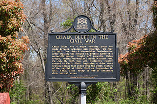
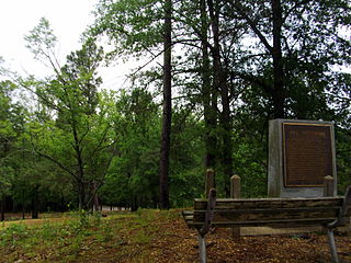
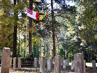
Chalk Bluff was an unincorporated community in Clay County, Arkansas, United States, approximately two miles (3 km) northwest of St. Francis. The town was formed in the 1820s at the point where the St. Francis River cuts through Crowley's Ridge from west to east. The name of the community was derived from the white clay bluff created by this crossing. The founder of the community was Abraham Seitz, who established and operated a ferry crossing and general store in the area from the 1830 until it was destroyed during the Civil War. The community occupied a strategic location and was often referred to in the reports of Union and Confederate forces vying for control of Northeast Arkansas during the war. Several skirmishes occurred near the ferry crossing, one of which was significant it enough to become known as the Battle of Chalk Bluff, which took place in early May 1863. The town was abandoned following the Civil War and most residents moved to the new railroad town, St. Francis, Arkansas. The location was listed on the National Register of Historic Places in 1974.
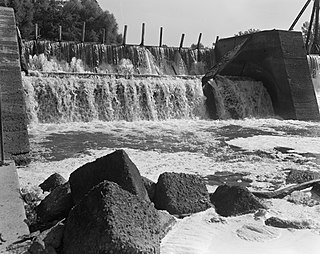
The Ouachita River Lock and Dam No. 8 are a historic lock and dam on the Ouachita River in Calhoun County, Arkansas. The area is managed by the county and the Arkansas Fish and Game Commission as a public recreation area. The facility offers a boat ramp and a few campsites.
The Camden Water Battery is a series of defenses established along the banks of the Ouachita River in Camden, Arkansas during the American Civil War. These defenses, little more than a series of rifle pits, were built during the fall of 1864, and were designed to address a weakness in Camden's defense that had been observed by both Confederate and Union forces during the failed Camden Expedition, an effort by Union forces to reach Shreveport, Louisiana from Little Rock. The defenses are believed to have been built by Texas troops stationed there after the withdrawal of Union forces.
The SS Homer was a sidewheel paddle steamer which plied the waters of the Mississippi River and its tributaries. Built in 1859 in Parkersburg, West Virginia, she was 148 feet (45 m) long, 28 feet (8.5 m) wide, and 5 feet (1.5 m) deep. Her first significant service was in 1860, when she was used as a packet steamer on the Red and Ouachita Rivers, under master and co-owner Samuel Applegate. In 1861, after the start of the American Civil War, she was contracted to the government of the Confederate States of America, and was used to transport men and war materiel. She was used to supply the defenders of Port Hudson, Louisiana, in 1864. That year she was captured by the Union Army forces of General Frederick Steele when she was about 30 miles (48 km) below Camden, Arkansas on the Ouachita River. Steele was at the time engaged in a major expedition whose goal was to reach Shreveport, Louisiana, but had stalled due to Confederate resistance and a lack of supplies. Steele had then occupied Camden, and it was during this occupation that the ship was taken, loaded with grain and other supplies. The Union forces piloted her back to Camden.

Oakland Farm is a historic farmhouse at the northern end of Oakland Street in Camden, Arkansas. The 1+1⁄2-story cypress house was built in 1886, and stands on one of the largest and most prominent estates in Camden. The house was built by William Frank Tate, descendant of Ouachita County's first English settler, John Tate, and remains in the Tate family. It has a T shape, with a main block and a series of additions which give it that shape. A veranda supported by Doric columns spans the width of the main facade.

Tate's Barn is a historic barn in Camden, Arkansas. It is located on the Oakland Farm, a 96-acre (39 ha) property off Oakland Street, belonging to the Tate family, who were among Ouachita County's first American settlers. The barn, probably built in the 1880s, is a cypress structure with a complex floor plan spanning five levels. It is 37 feet (11 m) wide and 50 feet (15 m) long, with a potato cellar, corn storage rooms, equipment storage, and two levels of hay loft. Two sheds are attached to the barn, one housing horse stalls, the other farm implements.

The Benjamin T. Powell House is a historic house at 305 California Avenue in Camden, Arkansas. The two story wood-frame house was built in 1859, and is one a few pre-Civil War cotton-magnate houses to survive in the city. The house has a cypress frame, and features a Classical Revival facade with a front gable supported by four round columns sheltering porches with ornamental iron railings. The house was used as a military headquarters by Union Army forces during the Civil War.

The Dooley's Ferry Fortifications Historic District encompasses a series of military earthworks erected in southwestern Arkansas, along the Red River in Hempstead County. They were constructed in late 1864 by Confederate troops under orders from Major-General John B. Magruder as a defense against the potential movements of Union Army forces toward Shreveport, Louisiana. They command a formerly major road intersection just east of Dooley's Ferry, one of the most important regional crossings of the Red River. After the war a cemetery for African-Americans was established adjacent to one of the gun emplacements.
The Wittsburg Fortification is a defensive earthworks built during the American Civil War in Wittsburg, Arkansas. It is the only known surviving earthworks built by either side during the Union Army's advance on Little Rock in 1862. Union forces invaded Arkansas from Missouri on July 19, 1862, moving south along Crowley's Ridge, which lies west of the St. Francis River. By July 29 most of the division of General John Davidson had advanced as far as Wittsburg, where they established a camp to wait for supplies and reinforcements. A stockade and ditch were built on the ridge overlooking the area.
References
- 1 2 "National Register Information System". National Register of Historic Places . National Park Service. July 9, 2010.
- ↑ "Tate's Bluff Fortification". Arkansas Preservation. Retrieved 2015-08-25.