This article needs additional citations for verification .(November 2022) |
Templeton | |
---|---|
Templeton Park | |
![]() Location in San Luis Obispo County and the state of California | |
Coordinates: 35°33′14″N120°42′34″W / 35.55389°N 120.70944°W | |
Country | ![]() |
State | ![]() |
County | San Luis Obispo |
Area | |
• Total | 7.766 sq mi (20.115 km2) |
• Land | 7.717 sq mi (19.988 km2) |
• Water | 0.049 sq mi (0.127 km2) 0.63% |
Elevation | 807 ft (246 m) |
Population | |
• Total | 8,386 |
• Density | 1,100/sq mi (420/km2) |
Time zone | UTC-8 (Pacific (PST)) |
• Summer (DST) | UTC-7 (PDT) |
ZIP code | 93465 |
Area code | 805 |
FIPS code | 06-78162 |
GNIS feature IDs | 1661557, 2410065 |
Templeton is a census-designated place (CDP) in San Luis Obispo County, California, United States. The population was 7,674 at the 2010 census, up from 4,687 at the 2000 census.
Templeton is located at 35°33′14″N120°42′34″W / 35.55389°N 120.70944°W (35.553847, −120.709469). [4] It is approximately five miles (8 km) south of Paso Robles and five miles north of Atascadero along U.S. 101. State Route 46 intersects U.S. 101 on the north edge of the town.
According to the United States Census Bureau, the CDP has a total area of 7.8 square miles (20 km2), 99.37% of it land and 0.63% water. However, much of the surrounding unincorporated area between Atascadero and Paso Robles is considered as part of Templeton, with most U.S. mail for this area addressed as such.
Templeton has a Mediterranean climate that is characterized by mild winters and dry summers. The area usually has low humidity. Rain generally falls only between November and March, with the rainy season tapering off almost completely by the end of April. Temperature lows can reach from 20 to 25 °F (−7 to −4 °C) in the winter, and highs can reach 100 °F (38 °C) in the summer, with the highest recorded temperature being 115 °F (46 °C).
Like much of the nearby area, Templeton occasionally receives significant but temporary fog through parts of the year. In summer, Templeton will occasionally receive fog due to its proximity with the California Coastal Range, Pacific Ocean, and the higher valley temperatures of Templeton itself; the differential in density between the warm rising air in the valley causes it to be displaced with the descent of the cooler marine air layer via the Templeton Gap in the Santa Lucia Range. Similarly, in winter, Templeton will occasionally receive morning fog due to the temperature differential with the Central Valley.
Although it is rare to see snow in Templeton, it did snow on December 15, 1988, leaving between 5 and 8 inches (13 and 20 cm) of total snowfall. [5] It also most recently snowed in the winter of 2023.
This section needs additional citations for verification .(November 2022) |
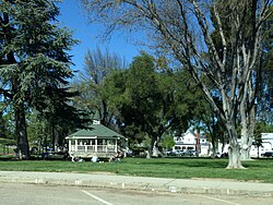
Templeton is home to numerous businesses that serve local agriculture and ranching, with the economy comprised most significantly from medical care including the Twin Cities Hospital, Templeton Unified School District, agriculture consisting primarily of vineyards and wineries, and assorted businesses on Main Street. Many residents work in nearby communities.
Templeton is emerging as a world class wine producer; [6] with many of the wineries carrying the "Paso Robles" appellation actually located in the unincorporated Templeton area – including Castoro Cellars, Peachy Canyon, York Mountain, and Wild Horse.
There is a growing production of olive oil, with many small groves producing olives intended for consumption and oil, including Pasolivo.
Templeton is located within the former Rancho Paso de Robles Mexican land grant and was founded in 1886 when Chauney Hatch Phillips of the West Coast Land Company sent R.R. Harris to survey 160 acres (0.65 km2) set aside for a town to exist south of Paso Robles as part of the company's larger purchase of 63,000 acres (250 km2). These 160 acres were to be laid out in business and residential lots with 5–12 acre parcels, with the town to be named "Crocker" after a Vice President of the Southern Pacific Railroad, Charles F. Crocker; however, Crocker instead chose to name the town "Templeton," after his two-year-old son, Charles Templeton Crocker.
The town was briefly the end of the line for passengers travelling south via the Southern Pacific Railroad from northern California; passengers disembarked at Templeton and were then carried by stagecoach south to San Luis Obispo. In 1889, the railroad was continued 14 miles (23 km) south to Santa Margarita and the town was reclassified to a flag stop. Currently, the railroad stops in nearby Paso Robles before continuing on, and Templeton is classified as a bypass.
In 1898, a fire destroyed most of the original wooden buildings of the business district along Main Street, prompting this section of the town to be rebuilt with brick, although on a somewhat smaller scale than before. [7]
The 2010 United States Census [8] reported that Templeton had a population of 7,674. The population density was 988.1 inhabitants per square mile (381.5/km2). The racial makeup of Templeton was 6,833 (89.0%) White, 59 (0.8%) African American, 80 (1.0%) Native American, 123 (1.6%) Asian, 10 (0.1%) Pacific Islander, 337 (4.4%) from other races, and 232 (3.0%) from two or more races. Hispanic or Latino of any race were 1,171 persons (15.3%).
The Census reported that 7,580 people (98.8% of the population) lived in households, 1 (0%) lived in non-institutionalized group quarters and 93 (1.2%) were institutionalized.
There were 2,830 households, of which 1,121 (39.6%) had children under the age of 18 living in them, 1,572 (55.5%) were opposite-sex married couples living together, 363 (12.8%) had a female householder with no husband present, 127 (4.5%) had a male householder with no wife present. There were 117 (4.1%) unmarried opposite-sex partnerships and 29 (1.0%) same-sex married couples or partnerships. 654 households (23.1%) were made up of individuals, and 352 (12.4%) had someone living alone who was 65 years of age or older. The average household size was 2.68. There were 2,062 families (72.9% of all households); the average family size was 3.14.
2,049 people (26.7%) of the population were under the age of 18, 598 people (7.8%) aged 18 to 24, 1,627 people (21.2%) aged 25 to 44, 2,288 people (29.8%) aged 45 to 64, and 1,112 people (14.5%) who were 65 years of age or older. The median age was 40.8 years. For every 100 females, there were 89.1 males. For every 100 females age 18 and over, there were 84.6 males.
There were 3,006 housing units at an average density of 387.1 per square mile (149.5/km2), of which 2,002 (70.7%) were owner-occupied, and 828 (29.3%) were occupied by renters. The homeowner vacancy rate was 1.2%; the rental vacancy rate was 6.9%. 5,453 people (71.1% of the population) lived in owner-occupied housing units and 2,127 people (27.7%) lived in rental housing units.
At the 2000 census, [9] there were 4,687 people, 1,548 households and 1,247 families residing in the CDP. The population density was 989.2 inhabitants per square mile (381.9/km2). There were 1,588 housing units at an average density of 335.2 per square mile (129.4/km2). The racial makeup of the CDP was 90.36% White, 1.17% African American, 0.70% Native American, 0.92% Asian, 0.09% Pacific Islander, 3.63% from other races, and 3.14% from two or more races. Hispanic or Latino of any race were 11.82% of the population.
There were 1,548 households, of which 49.7% had children under the age of 18 living with them, 65.4% were married couples living together, 11.5% had a female householder with no husband present, and 19.4% were non-families. 15.6% of all households were made up of individuals, and 7.8% had someone living alone who was 65 years of age or older. The average household size was 2.98 and the average family size was 3.33.
33.7% of the population were under the age of 18, 5.9% from 18 to 24, 29.8% from 25 to 44, 19.2% from 45 to 64, and 11.5% who were 65 years of age or older. The median age was 36 years. For every 100 females, there were 93.2 males. For every 100 females age 18 and over, there were 88.4 males.
The median household income was $53,438 and the median family income was $58,750. Males had a median income of $41,268 compared with $32,034 for females. The per capita income for the CDP was $19,671. About 6.3% of families and 9.1% of the population were below the poverty line, including 11.5% of those under age 18 and 4.7% of those age 65 or over.
Templeton is governed by the five-member board of the Templeton Community Services District. [10]
The current board members are:
In the state legislature, Templeton is in the 17th Senate District , represented by Democrat John Laird, and in the 35th Assembly District , represented by Democrat Jasmeet Bains. [12]
In the United States House of Representatives, Templeton is in California's 24th congressional district , represented by Democrat Salud Carbajal. [13]
Public schools in Templeton are located in and operated by the Templeton Unified School District, which notably includes Templeton High School, which was selected as a National Blue Ribbon High School in 2006, having previously been selected in both 1999 and 2005 as one of 64 schools out of 860 in the state of California as a California Distinguished School.
Three Points is a census-designated place (CDP) in Pima County, Arizona, United States. The population was 5,581 at the 2010 census.
Alondra Park, also known as El Camino Village, is a census designated place (CDP) in the South Bay region of Los Angeles County, California, United States. It is the unincorporated area north of Alondra Community Regional Park and El Camino College. It is east of Lawndale, south of Hawthorne, west of Gardena, and north of Torrance. Manhattan Beach Boulevard and Crenshaw Boulevard are the two major cross streets in the area. The population was 8,569 at the 2020 census, down from 8,592 at the 2010 census. There is an official Alondra Park Post Office of the U.S. Postal Service in nearby Gardena, California. Urbanized cement-lined Dominguez Creek bisects a portion of Alondra Park.
South San Gabriel is a census-designated place (CDP) in Los Angeles County, California, United States. The population was 8,070 at the 2010 census, up from 7,595 at the 2000 census.
Boronda is an unincorporated community and census-designated place (CDP) in Monterey County, California, United States. The population was 1,760 at the 2020 census. Boronda is located directly west of Salinas and is named after José Eusebio Boronda, a Californio ranchero, and located on the lands of his Rancho Rincón del Sanjón.
Bradley is an unincorporated community and census-designated place (CDP) in Monterey County, California, on the Salinas River 14 miles (23 km) south-southeast of San Ardo and 20 miles (32 km) north of Paso Robles. Bradley sits at an elevation of 548 feet (167 m). The population was 69 at the 2020 census, down from 93 at the 2010 census.
San Ardo, formerly known as San Bernardo, is an unincorporated community and census-designated place (CDP) in Monterey County, California, United States. San Ardo is located 18 miles (29 km) southeast of King City at an elevation of 449 feet (137 m). The population was 392 at the 2020 census, down from 517 in 2010.
San Lucas is an unincorporated community and census-designated place (CDP) in Monterey County, California, United States. It was founded in 1886 and named after the Rancho San Lucas, which was granted in 1842. The post office was first established in 1892.
North Tustin is an unincorporated community and census designated place (CDP) in Orange County, California. The population was 25,718 at the 2020 census, up from 24,917 in 2010. For statistical purposes, the United States Census Bureau has defined North Tustin as a census-designated place (CDP). It is both the largest CDP and largest unincorporated community in Orange County. The CDP's name was changed from Tustin Foothills in 2005. Located outside the city limits of Tustin, North Tustin has 92705 and 92780 ZIP Codes.
El Cerrito is a census-designated place (CDP) in Riverside County, California, United States. It is an unincorporated area mostly surrounded by the city of Corona. The population was 5,100 at the 2010 census, up from 4,590 at the 2000 census.
Bonsall is a census-designated place (CDP) in San Diego County, California. The population was 3,982 at the 2010 census, up from 3,401 at the 2000 census.
La Presa is a census-designated place (CDP) in the East County region of San Diego County, California, United States. The population was 34,169 at the 2010 census, up from 32,721 at the 2000 census.
San Miguel is a unincorporated community in San Luis Obispo County, California, United States. As of the 2010 census, the population was 2,336. For statistical purposes, the United States Census Bureau has defined San Miguel as a census-designated place (CDP). San Miguel was founded by the Spanish in 1797, when Mission San Miguel Arcángel was established by Fermín de Lasuén. San Miguel is a tourist destination with historic architecture and vineyards, as part of the Paso Robles wine region.
Shandon is a village and census-designated place (CDP) in San Luis Obispo County, California, United States. The population was 1,295 at the 2010 census, up from 986 at the 2000 census. Shandon lies by the San Juan River.
Stanford is a census-designated place (CDP) in the northwest corner of Santa Clara County, California, United States. It is the home of Stanford University, after which it was named. The CDP's population was 21,150 at the 2020 census. Stanford is adjacent to the city of Palo Alto, which borders it to the east, but the CDP itself remains unincorporated.
Ducor is a census-designated place (CDP) in Tulare County, California, United States. The population was 616 at the 2020 census, up from 612 at the 2010 census. Ducor is an abbreviation of an earlier name, Dutch Corners, which was given because several early settler families were German. The word "Dutch" in this case derives from German deutsch "German".
Del Monte Forest is a census-designated place (CDP) in Monterey County, California, United States. As of the 2020 census, the CDP had a total population of 4,204, down from 4,514 at the 2010 census. The census area includes the separate well-known community of Pebble Beach.
Agua Dulce is an unincorporated community and census-designated place (CDP) in El Paso County, Texas, United States. The population was 3,218 at the 2020 census. It is part of the El Paso Metropolitan Statistical Area. The ZIP Code encompassing the CDP area is 79928.
Butterfield is a census-designated place (CDP) in El Paso County, Texas, United States. The population was 100 at the 2020 census. It is part of the El Paso Metropolitan Statistical Area. The ZIP Code encompassing the CDP area is 79938.
Canutillo is a census-designated place (CDP) in El Paso County, Texas, United States. The population was 6,321 at the 2010 census. It is part of the El Paso Metropolitan Statistical Area. The ZIP Codes encompassing the CDP area are 79835 and 79932.
Westway is a census-designated place (CDP) in El Paso County, Texas, United States. The population was 4,188 at the 2010 census. It is part of the El Paso Metropolitan Statistical Area. It is located east of Interstate 10, approximately 2 miles (3 km) from the New Mexico - Texas state line.