
Kingston Pike is a highway in Knox County, Tennessee, United States, that connects Downtown Knoxville with West Knoxville, Farragut, and other communities in the western part of the county. The road follows a merged stretch of U.S. Route 11 (US 11) and US 70. From its initial construction in the 1790s until the development of the Interstate Highway System in the 1960s, Kingston Pike was the main traffic artery in western Knox County, and an important section of several cross-country highways. The road is now a major commercial corridor, containing hundreds of stores, restaurants, and other retail establishments.
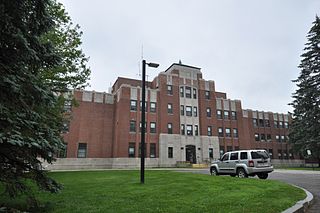
Togus, formally known as the Togus VA Medical Center, is a facility operated by the United States Department of Veterans Affairs in Chelsea, Maine. The facility was built as a resort hotel, and housed Union veterans of the American Civil War prior to being converted to a veterans hospital. It was the first veterans facility developed by the United States government.

The Barre Common District is a historic district encompassing the town common of Barre, Massachusetts, and immediately adjacent historic buildings. It is bounded roughly by South, Exchange, Main, Pleasant, Broad, School and Grove Streets. The Barre common was laid out in 1792, and has been a focus of the town's civic life ever since, and is flanked by a number of high-quality Greek Revival buildings, as well as those in other styles. The district was listed on the National Register of Historic Places in 1976.

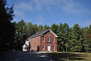
The Sturbridge Common Historic District encompasses the historic center of Sturbridge, Massachusetts. Encompassing some 138 acres (56 ha), the district is focused around the town common, which was laid out when the town established in 1738. The district is roughly linear, extending along Main Street from its junction with Interstate 84 eastward to Hall Road. The district also extends for short distances along Haynes, Maple, and Charlton Streets. Although most of the properties in the district are residential, the institutional properties, including the 1838 Greek Revival Town Hall, the 1896 Joshua Hyde Library building, and the 1922 Federated Church. The oldest building in the district is the c. 1772 Publick House, a tavern which has dominated the south side of the district since its construction.

Center Cemetery is a historic cemetery on the south side of Sam Hill Road in Worthington, Massachusetts. The 2.4-acre (0.97 ha) cemetery was established c. 1774, and continues to be used today. Its burials include many of the founders and early settlers of Worthington, and of families influential in the growth and development of the town. The cemetery listed on the National Register of Historic Places in 2004.

Hubbardston Town Common Historic District encompasses the town common of Hubbardston, Massachusetts, the adjacent 1773 First Parish Church, and the town's first burying ground. It has been the center of the town's civic and religious life since its incorporation in the 1760s, and was listed on the National Register of Historic Places in 2000. The district was named as one of the 1,000 Places to Visit in Massachusetts by the Great Places in Massachusetts Commission.

Glenwood Cemetery is a historic rural cemetery northeast of Parker Street and Great Road in Maynard, Massachusetts. It is one of the first municipal creations of the town after its incorporation in 1871, and is the resting place of many of its early and prominent residents, including Amory Maynard, founder of the Assabet Woolen Mill and namesake of the community. The cemetery was added to the National Register of Historic Places (NR#04000425) on May 12, 2004.

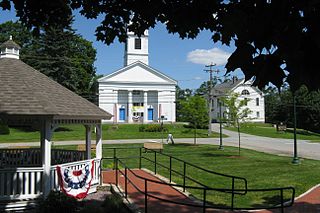
The Belchertown Center Historic District is a historic district which encompasses the historic village center of Belchertown, Massachusetts. Centered on Belchertown's 1,200-foot (370 m) common, the district includes 55 contributing properties along South Main Street, Maple Street, and a few adjacent streets. It was listed on the National Register of Historic Places in 1982.

Grindel Point Light is a lighthouse in Islesboro, Maine, marking the west entrance to Gilkey Harbor at the westernmost point of the eponymous island. The light station was established in 1850, and the present tower and keeper's house were built in 1874. The station was deactivated in 1934 and reactivated in 1987. It was listed on the National Register of Historic Places in 1987. The keeper's house now houses the Grindel Point Sailor's Museum and the lighthouse tower is open for tours in the summer.

The Conway House is an historic house and museum in Rockport and Camden, Maine. Probably built in the 1770s, it is one of the oldest surviving buildings in Knox County. It was added to the National Register of Historic Places in 1969.

Swampscott Cemetery is a historic cemetery at 400 Essex Street in Swampscott, Massachusetts. It is the town's only cemetery, and was established in 1852, not long after the town's incorporation. About 20 acres (8.1 ha) of the cemetery's 30 hectares have been listed on the National Register of Historic Places. Its historic portion is a representative of the rural cemetery movement that was popular in the 19th century, with meandering lanes and natural landscaping.

The Hancock Village Historic District encompasses the town center of Hancock, New Hampshire. It extends the length of Hancock's Main Street, from Pine Ridge Cemetery and the common to the west, and the junction of Bennington, Norway Hill, and Forest roads to the east. It then extends a short way up Bennington Road. The common was laid out in 1785, and the village developed nearby over the next 100+ years. The district was listed on the National Register of Historic Places in 1988.
The Newington Center Historic District encompasses the historic civic heart of Newington, New Hampshire. It consists of a section of Nimble Hill Road between its junction with Little Bay Road, and a gate at the southern end marking the start of territory formerly associated with Pease Air Force Base. This area includes the town common, laid out in 1640, a cluster of civic buildings, and several private residences, as well as remnants of the state's oldest town forest. The district was listed on the National Register of Historic Places in 1987; in 1991 an additional 69 acres (28 ha) of former town forest, now part of the airfield, were added to the district.

The Lower Meeting House and East Bethel Cemetery are a historic religious property at 1797 Intervale Road in Bethel, Maine. The meeting house, built in 1831 and only modestly modified since, is a good local example of a typical rural church of the period in Maine; the cemetery has been in use for a longer period, with its oldest dated burial occurring in 1817. The property was listed on the National Register of Historic Places in 2013.

The Chestnut Street Historic District encompasses a predominantly residential part of Camden, Maine, United States, which represents a cross-section of the town's architectural history, and of its transition from a shipping center to a summer resort community. The district extends south from the town common, along Chestnut Street, and then east to Dillingham Point. It was listed on the National Register of Historic Places in 1991.
The Union Meeting House is a historic church at 2875 Sennebec Road in Appleton, Maine. Built in 1848, it is a fine local example of Greek Revival architecture. It has served a variety of congregations, and housed the town library for a time. It is now owned by the local historical society. It was listed on the National Register of Historic Places in 2014.

The Battery Street Historic District encompasses one of the oldest developed areas of Burlington, Vermont. With a history dating to 1790, this area, south of downtown Burlington and initially bounded roughly by Main, St. Paul, and Maple Streets, and Lake Champlain, this area includes a mix of residential, commercial, and industrial uses, with architecture spanning from its early period to the 20th century, including one of the city's oldest houses. The district was listed on the National Register of Historic Places in 1977, and has twice been enlarged, extending west to South Union Street.
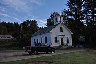
The Wheelock Common Historic District encompasses the traditional town center of the small northeastern Vermont community of Wheelock. Located at the junction of Vermont Route 122 and Sutton Road, it includes the town common, town hall, and cemetery. The district was listed on the National Register of Historic Places in 2007.
The historical buildings and structures of Yarmouth, Maine, represent a variety of building styles and usages, largely based on its past as home to almost sixty mills over a period of roughly 250 years. These mills include that of grain, lumber, pulp and cotton. Additionally, almost three hundred vessels were launched by Yarmouth's shipyards in the century between 1790 and 1890, and the homes of master shipwrights and ship captains can still be found throughout the town.
The Oakham Center Historic District encompasses a portion of the historic town center of Oakham, Massachusetts. Roughly bounded by Coldbrook Rd., Maple St., Barre Rd., and Deacon Allen Drive, the area was formed as a civic center about 1770, with town incorporation following in 1775. It includes a well-preserved variety of early 19th-century residential architecture, as well as the town's Greek Revival Congregational church, and its 1908 library. The district was listed on the National Register of Historic Places in 2020.


