The Dalles Mint

Last updated
The Dalles Mint
The Dalles Mint blueprint.jpg
Original design for the building
The Dalles OR - OpenStreetMap.png
Red pog.svg
Location in The Dalles, Oregon
General information
Location The Dalles, Oregon
Address710 E. Second Street
The Dalles, Oregon
CountryUS
Coordinates 45°35′54″N121°10′36″W / 45.598431°N 121.176716°W / 45.598431; -121.176716 Coordinates: 45°35′54″N121°10′36″W / 45.598431°N 121.176716°W / 45.598431; -121.176716
Construction started1869
Cost$105,000
OwnerThe Mint LLC
Height35 ft (11 m)
Dimensions
Diameter50 ft × 60 ft (15 m × 18 m)
Technical details
Floor count1

The Dalles Mint was to be a branch of the United States Mint in The Dalles in Oregon. Partially constructed in 1869, the planned two-story structure was never completed and the mint was never put into operation. Located in the downtown area of the city, the building was given to the state before it was sold to the public.[ citation needed ] The Mint building was most recently home to the Erin Glenn Winery.

Contents

History

In 1860, gold was discovered in Idaho, and this along with a gold rush in Eastern Oregon created a need for a mint in the Pacific Northwest. [1] [2] Although the American Civil War was underway, 80,000 prospectors headed for the gold fields in 1862. [3] Raw gold dust was used as currency in The Dalles [3] because gold had to be shipped to the San Francisco Mint for processing. Demand grew for a mint closer to the mines. [3]

Oregon U.S. Senator James W. Nesmith introduced an unsuccessful bill in 1862 to create a mint in Portland, Oregon. [3] On July 4, 1864, Congress passed a bill to authorize a new branch of the mint at The Dalles (then known as Dalles City) for minting gold and silver coins. [1] [3] The next year another bill unsuccessfully attempted to change the location for the mint to Portland. [3] William Logan was appointed as superintendent of the planned mint, but he died in the shipwreck of the S.S. Brother Jonathan en route to The Dalles. [3]

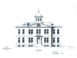
Mary Laughlin donated a block of land on June 6, 1865, as a site for the mint [3] and in 1869, construction finally began with Harvey A. Hogue as the superintendent of construction. [1] [3] However, the project was repeatedly delayed, and as the gold rushes waned and the Central Pacific Railroad opened, the mint become obsolete before the building could be completed and the minting equipment could be installed. [1] [2] [3] [4] [5] The basement and first floor were completed in 1869, but in 1870 the construction was suspended, and officially abandoned in 1873. [3] A fire destroyed much of the city in 1871, but the fact the mint was in the middle of the city block served as a firebreak and helped stop the fire. [3]

In 1875, the federal government gave the structure to the State of Oregon, who in turn sold it to private interests in 1889. [3] By 1940, the building was being used by the Columbia Warehouse Company. [4] A fire in 1943 damaged the mint building, which in 1947 was repaired. [3] The structure was also owned by Ralph's Transfer & Storage Co. before becoming the home of the Erin Glenn Winery in 2007 after a $1.5 million renovation. [3] [6]

Structure

The single story, 35-foot (11 m) high granite building also has a basement. [2] The building has a flat roof, with arched windows. [7] Stone for the building was quarried from Mill Creek and shipped by wagon to the site. [7] The building measured 50 feet (15 m) by 60 feet (18 m) and cost $105,000. [2] Built in the center of the block, the original plans called for a two-storey building to be 90 feet (27 m) by 51 feet (16 m). [3] A concrete block section was later added to the north side of the original structure. [7] The building is eligible for the National Register of Historic Places (NRHP), [8] but is just outside the NRHP-listed The Dalles Commercial Historic District. [9]

See also

Related Research Articles

<span class="mw-page-title-main">Hood River, Oregon</span> City in Oregon, United States

The city of Hood River is the seat of Hood River County, Oregon, United States. It is a port on the Columbia River, and is named for the nearby Hood River. As of the 2020 census, the city population was 8,313. It is the only city in Oregon where public consumption of alcohol on sidewalks or parks is totally unrestricted.

<span class="mw-page-title-main">The Dalles, Oregon</span> City in the United States

The Dalles is the largest city of Wasco County, Oregon, United States. The population was 16,010 at the 2020 census, and it is the largest city on the Oregon side of the Columbia River between the Portland Metropolitan Area, and Hermiston.

<span class="mw-page-title-main">Shaniko, Oregon</span> City in Oregon, United States

Shaniko is a city located in Wasco County, Oregon, United States, on U.S. Route 97 and about 8 miles (13 km) north of Antelope. The population was 36 at the 2010 census.

<span class="mw-page-title-main">Hubert Howe Bancroft</span> 19th and 20th-century American historian and ethnologist

Hubert Howe Bancroft was an American historian and ethnologist who wrote, published and collected works concerning the western United States, Texas, California, Alaska, Mexico, Central America and British Columbia.

<span class="mw-page-title-main">Columbia River Gorge</span> Canyon along the border of Oregon and Washington in the United States

The Columbia River Gorge is a canyon of the Columbia River in the Pacific Northwest of the United States. Up to 4,000 feet (1,200 m) deep, the canyon stretches for over eighty miles (130 km) as the river winds westward through the Cascade Range, forming the boundary between the state of Washington to the north and Oregon to the south. Extending roughly from the confluence of the Columbia with the Deschutes River in the east down to the eastern reaches of the Portland metropolitan area, the water gap furnishes the only navigable route through the Cascades and the only water connection between the Columbia Plateau and the Pacific Ocean. It is thus that the routes of Interstate 84, U.S. Route 30, Washington State Route 14, and railroad tracks on both sides run through the gorge.

<span class="mw-page-title-main">Multnomah Falls</span> Waterfall in Oregon, U.S.

Multnomah Falls is a waterfall located on Multnomah Creek in the Columbia River Gorge, east of Troutdale, between Corbett and Dodson, Oregon, United States. The waterfall is accessible from the Historic Columbia River Highway and Interstate 84. Spanning two tiers on basalt cliffs, it is the tallest waterfall in the state of Oregon at 620 ft (189 m) in height. The Multnomah Creek Bridge, built in 1914, crosses below the falls, and is listed on the National Register of Historic Places.

<span class="mw-page-title-main">Historic Columbia River Highway</span> Highway in Oregon, USA

The Historic Columbia River Highway is an approximately 75-mile-long (121 km) scenic highway in the U.S. state of Oregon between Troutdale and The Dalles, built through the Columbia River Gorge between 1913 and 1922. As the first planned scenic roadway in the United States, it has been recognized in numerous ways, including being listed on the National Register of Historic Places, being designated as a National Historic Landmark by the U.S. Secretary of the Interior, being designated as a National Historic Civil Engineering Landmark by the American Society of Civil Engineers, and being considered a "destination unto itself" as an All-American Road by the U.S. Secretary of Transportation. The historic roadway was bypassed by the present Columbia River Highway No. 2 from the 1930s to the 1950s, leaving behind the old two-lane road. The road is now mostly owned and maintained by the state through the Oregon Department of Transportation as the Historic Columbia River Highway No. 100 or the Oregon Parks and Recreation Department as the Historic Columbia River Highway State Trail.

<span class="mw-page-title-main">Crown Point (Oregon)</span> Basalt promontory in Oregon, USA

Crown Point is a basalt promontory on the Columbia River Gorge and an associated state park in the U.S. state of Oregon. It is located in eastern Multnomah County, approximately 15 miles (24 km) east of Portland. Crown Point is one of the scenic lookouts along the Historic Columbia River Highway, providing a panoramic view of part of the Columbia River. It stands 733 feet (223 m) above the river and is the remains of a lava flow that filled the ancestral channel of the Columbia River 14 to 17 million years ago. The Point was designated a National Natural Landmark in 1971.

<span class="mw-page-title-main">National Register of Historic Places listings in Multnomah County, Oregon</span>

The following list presents the full set of National Register of Historic Places listings in Multnomah County, Oregon. However, please see separate articles for listings in each of Portland's six quadrants.

<span class="mw-page-title-main">History of Oregon</span> History of the US state of Oregon

The history of Oregon, a U.S. state, may be considered in five eras: geologic history, inhabitation by native peoples, early exploration by Europeans, settlement by pioneers, and modern development.

<span class="mw-page-title-main">Interstate 84 in Oregon</span> Interstate highway in Oregon

Interstate 84 (I-84) in the U.S. state of Oregon is a major Interstate Highway that traverses the state from west to east. It is concurrent with U.S. Route 30 (US 30) for most of its length and runs 376 miles (605 km) from an interchange with I-5 in Portland to the Idaho state line near Ontario. The highway roughly follows the Columbia River and historic Oregon Trail in northeastern Oregon, and is designated as part of Columbia River Highway No. 2 and all of the Old Oregon Trail Highway No. 6; the entire length is also designated as the Vietnam Veterans Memorial Highway. I-84 intersects several of the state's main north–south roads, including US 97, US 197, I-82, and US 395.

<span class="mw-page-title-main">Steamboats of the Columbia River</span>

Many steamboats operated on the Columbia River and its tributaries, in the Pacific Northwest region of North America, from about 1850 to 1981. Major tributaries of the Columbia that formed steamboat routes included the Willamette and Snake rivers. Navigation was impractical between the Snake River and the Canada–US border, due to several rapids, but steamboats also operated along the Wenatchee Reach of the Columbia, in northern Washington, and on the Arrow Lakes of southern British Columbia.

William Overton was a pioneer of the Oregon Country in the Pacific Northwest region of North America. In the mid-1840s he purchased the land claim, along with Asa Lovejoy, for the site which would become Portland, Oregon. Overton sold his share shortly thereafter to Francis Pettygrove.

<span class="mw-page-title-main">Celilo Canal</span>

Celilo Canal was a canal connecting two points of the Columbia River between the states of Oregon and Washington, U.S. just east of The Dalles.

<span class="mw-page-title-main">Portland City Hall (Oregon)</span> Historic building in Portland, Oregon, U.S.

Portland City Hall is the headquarters of city government of Portland, Oregon, United States. The four-story Italian Renaissance-style building houses the offices of the City Council, which consists of the mayor and four commissioners, and several other offices. City Hall is also home to the City Council chambers, located in the rotunda on the east side of the structure. Completed in 1895, the building was added to the National Register of Historic Places on November 21, 1974. City Hall has gone through several renovations, with the most recent overhaul gutting the interior to upgrade it to modern seismic and safety standards. The original was built for $600,000, while the 1996 to 1998 renovation cost $29 million.

Edgar Marks Lazarus was an American architect who was prominent in the Portland, Oregon, area for more than 45 years. He was best known as the architect of the Vista House on Crown Point in the Columbia River Gorge.

<span class="mw-page-title-main">Bibliography of Oregon history</span>

For a useful starting point goto Oregon Encyclopedia of History and Culture (2022). Not yet in print format; it is online here with 2000 articles.

Elmer Edward Feig was an American unlicensed architect credited with designing over 81 apartment buildings between 1925 and 1931 in Portland, Oregon. Feig also designed single-family residences. Many of Feig's designs survived urban renewal and have become a central feature of Portland neighborhoods. Some of Feig's buildings are listed on the National Register of Historic Places.

Sherry Ross was an Oregon pioneer and the namesake of Ross Island and Ross Island Bridge in Portland, Oregon.

<span class="mw-page-title-main">Nathaniel H. Gates</span> Oregon lawyer and state legislator (1811–1889)

Nathaniel Holly Gates, also known as Colonel Gates for most of his life, (1811–1889) was an American pioneer lawyer and Oregon state legislator. He was an active Democrat throughout his life. He served four terms in Oregon's territorial legislature. This included one term as Speaker of the Oregon House of Representatives during the 1858 legislative session. After Oregon became a state in 1859, he served one two-year term in the Oregon House of Representatives and one four-year term in the Oregon State Senate. Before immigrating to Oregon, Gates lived and worked as a lawyer in Ohio and Iowa. After moving to Oregon, he settled in The Dalles and opened a law practice there. He helped develop that community and served as the city's mayor five times in non-consecutive terms.

References

  1. 1 2 3 4 Bancroft, Hubert Howe (1888). The Works of Hubert Howe Bancroft: History of Oregon. 1886-88. History Company. p.  724. The Dalles Mint.
  2. 1 2 3 4 Corning, Howard M. (1989) Dictionary of Oregon History. Binfords & Mort Publishing. p. 167.
  3. 1 2 3 4 5 6 7 8 9 10 11 12 13 14 15 16 Zimmerman, Brent (July 23, 2009). "Mint that Never Was Makes Interesting Tale". Numismatic News. Retrieved 31 December 2013.
  4. 1 2 Oregon, End of the Trail. Portland, Oregon: Oregon State Board of Control. 1940. p. 246. ISBN   9781623760366.
  5. Harte, Bret, ed. (March 1872). "The Gorge of the Columbia". The Overland Monthly. 8: 234.
  6. Oppenheimer, Laura (June 6, 2009). "Columbia Gorge bucks economic winds, especially in The Dalles". The Oregonian . Retrieved 1 January 2014.
  7. 1 2 3 "Bekins-Ralph's Transfer & Storage Co" (PDF). State of Oregon Inventory of Historic Properties. Oregon State Parks. Retrieved 1 January 2014.
  8. "Site Information: US Mint". Oregon Historic Sites Database. Oregon Parks & Recreation Department. Retrieved 1 January 2014.
  9. "The Dalles Commercial Historic District (1997 Update)". National Register of Historic Places Registration Form. United States Department of the Interior. p. 141. Retrieved 1 January 2014.