Saukville is a town in Ozaukee County, Wisconsin, United States. The Village of Saukville is located in the town's southeast quadrant. The population was 1,755 at the 2000 census.

Indiana Dunes National Park is a United States National Park located in Northwestern Indiana, managed by the National Park Service. It was authorized by Congress in 1966 as the Indiana Dunes National Lakeshore, the name by which it was known until it was designated the nation's 61st national park on February 15, 2019. The park runs for nearly 25 miles (40 km) along the southern shore of Lake Michigan; it contains approximately 15,000 acres (6,100 ha). Its visitors center is in Porter, Indiana. Located in the park are sand dune, wetland, prairie, river, and forest ecosystems.
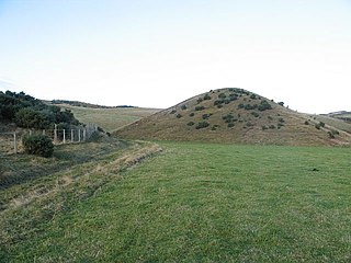
A kame is a glacial landform, an irregularly shaped hill or mound composed of sand, gravel and till that accumulates in a depression on a retreating glacier, and is then deposited on the land surface with further melting of the glacier. Kames are often associated with kettles, and this is referred to as kame and kettle topography. The word kame is a variant of comb, which has the meaning "crest" among others. The geological term was introduced by Thomas Jamieson in 1874.

A kettle is a depression/hole in an outwash plain formed by retreating glaciers or draining floodwaters. The kettles are formed as a result of blocks of dead ice left behind by retreating glaciers, which become surrounded by sediment deposited by meltwater streams as there is increased friction. The ice becomes buried in the sediment and when the ice melts, a depression is left called a kettle hole, creating a dimpled appearance on the outwash plain. Lakes often fill these kettles; these are called kettle hole lakes. Another source is the sudden drainage of an ice-dammed lake. When the block melts, the hole it leaves behind is a kettle. As the ice melts, ramparts can form around the edge of the kettle hole. The lakes that fill these holes are seldom more than 10 m (33 ft) deep and eventually become filled with sediment. In acid conditions, a kettle bog may form but in alkaline conditions, it will be kettle peatland.
Fluvio refers to things related to rivers and glacial refers to something that is of ice. Fluvio-glacial refers to the meltwater created when a glacier melts. Fluvio-glacial processes can occur on the surface and within the glacier. The deposits that happen within the glacier are revealed after the entire glacier melts or partially retreats. Fluvio-glacial landforms and erosional surfaces include: outwash plains, kames, kame terraces, kettle holes, eskers, varves, and proglacial lakes.

Big Bog State Recreation Area, a recent addition to the Minnesota state park system, is located on Minnesota State Highway 72, north of Waskish, Minnesota. It covers 9,459 acres (38.3 km2), primarily swamps, bogs, and upland "islands".

Lake Bemidji State Park is a state park of Minnesota, United States, on the north shore of 6,765-acre (27.38 km2) Lake Bemidji. The northern half of the park preserves a spruce-tamarack bog. A district of National Park Service rustic structures built by the Civilian Conservation Corps and National Youth Administration in the 1930s is on the National Register of Historic Places. The park is located 5 miles (8.0 km) north of the city of Bemidji.

Kettle Moraine is a large moraine in the state of Wisconsin, United States. It stretches from Walworth County in the south to Kewaunee County in the north. It has also been referred to as the Kettle Range and, in geological texts, as the Kettle Interlobate Moraine.
The Tannersville Cranberry Bog or Cranberry Swamp is a sphagnum bog on the Cranberry Creek in Tannersville, Pennsylvania. It is the southernmost boreal bog east of the Mississippi River, containing many black spruce and tamarack trees at the southern limit of their ranges. Technically, it can be classed as an acid fen, as it receives some groundwater flow. The site was designated a National Natural Landmark in December 1974. It was purchased by The Nature Conservancy and the Conservation and Research Foundation in 1957. Like many bogs, its terrain presents an image of solidity, but a liquid mass of decaying peat lies beneath a six-inch (152 mm) layer of sphagnum and a network of supporting tree roots. However, this bog may be viewed from a floating walkway.
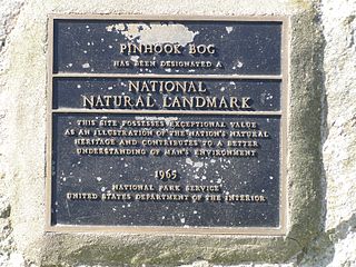
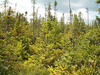
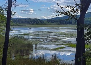
Pinhook Bog is a unique bog in Indiana that has been designated a National Natural Landmark. It is part of Indiana Dunes National Park, an area that many citizens, scientists, and politicians fought hard to preserve. Its sister bog, Volo Bog, is located nearby. The bog contains a large variety of plants, including insect eating plants, tamarack trees, stands of blueberry bushes, and floating mats of sphagnum moss. Pinhook Bog is about 580 acres (2.3 km2), a quarter of which is a floating mat of sphagnum peat moss. A "moat" separates the bog from the uplands.

Volo Bog State Natural Area is a nature reserve in Illinois, United States, preserving Volo Bog. The bog was designated a National Natural Landmark in 1973 as the only remaining open-water quaking bog in Illinois. The site also contains woodlands, savanna, marshes, prairie restoration areas, shrubland and old fields. Maintained by the Illinois Department of Natural Resources, the site is located about a mile west of U.S. Route 12 between the towns of Volo and Fox Lake, Illinois.

The Akron, Ohio, metropolitan statistical area, as defined by the United States Office of Management and Budget, is an area consisting of two counties, Summit and Portage, in Northeast Ohio and is anchored by the city of Akron. As of the 2010 census, the MSA had a population of 703,200.

Moss Lake Bog is an 84-acre (34 ha) site containing a 15-acre (6.1 ha) glacial kettle lake located in the town of Caneadea, New York, outside Houghton. Over time, sphagnum moss has grown over the open water, turning it into an acidic bog. It is managed by The Nature Conservancy as part of Moss Lake Preserve, and was declared a National Natural Landmark in 1973.
Thompson Pond in Pine Plains, New York is a 75-acre (30 ha) 15,000-year-old glacial kettle pond at the foot of 1,403-foot (428 m) Stissing Mountain. It is the source of Wappinger Creek, a tributary of the Hudson River that drains much of Dutchess County.
Quail Hollow Park is a 703-acre (284 ha) county park in Stark County, Ohio, in the United States. The park was opened to the public in 1975. It was previously a privately owned family farm and later a hunting camp. Quail Hollow Park is open for year-round recreation and features trail that are open to hiking, mountain biking and cross-country skiing, a small pond for fishing and ice skating as well as group camping and picnic facilities.

Singer Lake Bog is a 344-acre nature preserve in the U.S. state of Ohio. It is owned by the Cleveland Museum of Natural History. With more than fifty acres of leatherleaf bog, it is the largest of its kind in the state of Ohio. Within the nature preserve is a five acre kettle lake bog that features tamarack, poison sumac, cranberries, northern purple pitcher plant, round-leaved sundew and sphagnum.

The Massawepie Mire is a boreal peatland bog in Piercefield, New York, located near Massawepie Lake. Covering an area of over 900 acres, the mire is the largest bog in New York State. This large size is due to its position in a large, shallow glacial basin.
Kiser Lake Wetlands State Nature Preserve, or simply Kiser Lake Wetlands, is a 51 acres (21 ha) nature reserve located in Johnson Township, Champaign County, Ohio, United States. It is located wholly within the Kiser Lake State Park, and operated by the Ohio Department of Natural Resources.


