Underwood, Minnesota

Last updated
Underwood
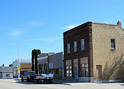
Underwood, Minnesota 02.jpg
Otter Tail County Minnesota Incorporated and Unincorporated areas Underwood Highlighted.svg
Location of Underwood, Minnesota
Coordinates: 46°17′13″N95°52′20″W / 46.28694°N 95.87222°W / 46.28694; -95.87222
CountryUnited States
State Minnesota
County Otter Tail
Founded1881
Incorporated1912
Government
   Mayor Paul Hoff
   City Council Bert Kinzler, Marilyn Olson, Rick Jacobson, and Jim Erpelding
Area
[1]
  Total0.59 sq mi (1.52 km2)
  Land0.59 sq mi (1.52 km2)
  Water0.00 sq mi (0.00 km2)
Elevation
[2]
1,342 ft (409 m)
Population
 (2020) [3]
  Total356
  Estimate 
(2021) [4]
363
  Density606.47/sq mi (234.30/km2)
Time zone UTC-6 (CST)
  Summer (DST) UTC-5 (CDT)
ZIP code
56586
Area code 218
FIPS code 27-66172
GNIS feature ID2397082 [2]
Website ci.underwood.mn.us

Underwood is a city in Otter Tail County, Minnesota, United States. The population was 356 at the 2020 census. [3]

Contents

History

Underwood was platted in 1881, and named for Adoniram Judson Underwood, a politician and editor of the Weekly Journal, a Fergus Falls-based newspaper. [5] [6] A post office has been in operation at Underwood since 1884. [7] Underwood was incorporated in 1912. [6]

Geography

According to the United States Census Bureau, the city has a total area of 0.58 square miles (1.50 km2), all land. [8]

Underwood is located between Fergus Falls and Battle Lake on Minnesota State Highway 210.

Demographics

Historical population
CensusPop.Note
1920 258
1930 30819.4%
1940 35314.6%
1950 336−4.8%
1960 314−6.5%
1970 278−11.5%
1980 33219.4%
1990 284−14.5%
2000 31912.3%
2010 3416.9%
2020 3564.4%
2021 (est.)363 [4] 2.0%
U.S. Decennial Census [9]
2020 Census [3]

2010 census

As of the census of 2010, there were 341 people, 159 households, and 104 families living in the city. The population density was 587.9 inhabitants per square mile (227.0/km2). There were 180 housing units at an average density of 310.3 per square mile (119.8/km2). The racial makeup of the city was 99.4% White, 0.3% African American, and 0.3% from two or more races. Hispanic or Latino of any race were 0.6% of the population.

There were 159 households, of which 23.9% had children under the age of 18 living with them, 52.2% were married couples living together, 8.2% had a female householder with no husband present, 5.0% had a male householder with no wife present, and 34.6% were non-families. 32.1% of all households were made up of individuals, and 15.1% had someone living alone who was 65 years of age or older. The average household size was 2.14 and the average family size was 2.67.

The median age in the city was 46.8 years. 20.8% of residents were under the age of 18; 5.5% were between the ages of 18 and 24; 20.8% were from 25 to 44; 28.5% were from 45 to 64; and 24.3% were 65 years of age or older. The gender makeup of the city was 50.7% male and 49.3% female.

2000 census

As of the census of 2000, there were 319 people, 142 households, and 95 families living in the city. The population density was 752.3 inhabitants per square mile (290.5/km2). There were 154 housing units at an average density of 363.2 per square mile (140.2/km2). The racial makeup of the city was 99.06% White, 0.31% Asian, and 0.63% from two or more races. Hispanic or Latino of any race were 0.63% of the population.

There were 142 households, out of which 28.2% had children under the age of 18 living with them, 55.6% were married couples living together, 9.9% had a female householder with no husband present, and 32.4% were non-families. 30.3% of all households were made up of individuals, and 20.4% had someone living alone who was 65 years of age or older. The average household size was 2.25 and the average family size was 2.74.

In the city, the population was spread out, with 23.2% under the age of 18, 8.8% from 18 to 24, 21.3% from 25 to 44, 20.1% from 45 to 64, and 26.6% who were 65 years of age or older. The median age was 40 years. For every 100 females, there were 87.6 males. For every 100 females age 18 and over, there were 84.2 males.

The median income for a household in the city was $29,000, and the median income for a family was $34,375. Males had a median income of $28,438 versus $21,875 for females. The per capita income for the city was $19,465. About 10.5% of families and 14.2% of the population were below the poverty line, including 11.5% of those under age 18 and 22.9% of those age 65 or over.
Education

Underwood is home to a single-campus primary and secondary school. In 2007 Underwood School District 550 was named one of the top 100 schools in the United States. The school team is the Rockets and its colors are black and orange.

Related Research Articles

<span class="mw-page-title-main">McClelland, Iowa</span> City in Iowa, United States

McClelland is a city in Pottawattamie County, Iowa, United States. The city was founded in 1903 after the Great Western Railroad was extended to include Council Bluffs, IA. The population was 146 at the time of the 2020 census.

<span class="mw-page-title-main">Langdon Place, Kentucky</span> City in Kentucky, United States

Langdon Place is a home rule-class city in Jefferson County, Kentucky, United States. The population was 936 as of the 2010 census.

<span class="mw-page-title-main">Alpha, Minnesota</span> City in Minnesota, United States

Alpha is a city in Jackson County, Minnesota, United States. The population was 116 at the 2010 census.

| official_name = Weimer Township, Ohio | settlement_type = Township | nickname = | motto = | image_skyline = | imagesize = | image_caption = | image_flag = | image_seal = | | pushpin_map = Minnesota#USA | pushpin_label_position = left | pushpin_map_caption = Location within the state of Minnesota | pushpin_mapsize = | image_map = | mapsize 99 = | map_caption = | image_map1 = | mapsize1 = | map_caption1 = | subdivision_type = Country | subdivision_name = United States | subdivision_type1 = State | subdivision_name1 = Minnesota | subdivision_type2 = County | subdivision_name2 = Jackson

<span class="mw-page-title-main">Bluffton, Minnesota</span> City in Minnesota, United States

Bluffton is a city in Otter Tail County, Minnesota, United States, along the Leaf River. The population was 210 at the 2020 census.

<span class="mw-page-title-main">Dalton, Minnesota</span> City in Minnesota, United States

Dalton is a city in Otter Tail County, Minnesota, United States. The population was 215 at the 2020 census.

<span class="mw-page-title-main">Deer Creek, Minnesota</span> City in Minnesota, United States

Deer Creek is a city in Otter Tail County, Minnesota, United States. The population was 330 at the 2020 census.

<span class="mw-page-title-main">Elizabeth, Minnesota</span> City in Minnesota, United States

Elizabeth is a city in Otter Tail County, Minnesota, United States. The population was 168 at the 2020 census.

<span class="mw-page-title-main">Erhard, Minnesota</span> City in Minnesota, United States

Erhard is a city in Otter Tail County, Minnesota, United States. The population was 132 at the 2020 census.

<span class="mw-page-title-main">Henning, Minnesota</span> City in Minnesota, United States

Henning is a city in Otter Tail County, Minnesota, United States. The population was 854 at the 2020 census.

<span class="mw-page-title-main">Nielsville, Minnesota</span> City in Minnesota, United States

Nielsville is a city in Polk County, Minnesota, United States. It is part of the Grand Forks, ND-MN Metropolitan Statistical Area. The population was 78 at the 2020 census.

<span class="mw-page-title-main">Farwell, Minnesota</span> City in Minnesota, United States

Farwell is a city in Pope County, Minnesota, United States. The population was 56 at the 2020 census.

<span class="mw-page-title-main">Underwood Township, Redwood County, Minnesota</span> Township in Minnesota, United States

Underwood Township is one of the twenty-six townships of Redwood County, Minnesota, United States. The population was 215 at the 2000 census.

<span class="mw-page-title-main">Minnesota City, Minnesota</span> City in Minnesota, United States

Minnesota City is a city in Winona County, Minnesota, United States. The population was 202 at the 2020 census.

<span class="mw-page-title-main">Underwood, North Dakota</span> City in North Dakota, United States

Underwood is a city in McLean County, North Dakota, United States. The population was 784 at the 2020 census.

<span class="mw-page-title-main">New Underwood, South Dakota</span> City in South Dakota, United States

New Underwood is a city in Pennington County, South Dakota, United States. The population was 590 at the 2020 Census.

<span class="mw-page-title-main">Iredell, Texas</span> City in Texas, United States

Iredell is a city located in Bosque County in central Texas, United States. The population was 339 at the 2010 census.

<span class="mw-page-title-main">Dennison, Minnesota</span> City in Minnesota, United States

Dennison is a city in Goodhue and Rice counties in the U.S. state of Minnesota. The population was 212 at the 2010 census. Most of Dennison is in Goodhue County, with only a small part that extends into Rice County.

<span class="mw-page-title-main">Minneiska, Minnesota</span> City in Minnesota, United States

Minneiska is a city in Wabasha and Winona counties in the U.S. state of Minnesota. The population was 111 at the 2010 census.

<span class="mw-page-title-main">Newfane (CDP), New York</span> CDP in New York, United States

Newfane is a census-designated place (CDP) in the town of Newfane in Niagara County, New York, United States, along State Route 78. The population was 3,822 at the 2010 census. It is part of the Buffalo–Niagara Falls Metropolitan Statistical Area.

References

  1. "2020 U.S. Gazetteer Files". United States Census Bureau. Retrieved July 24, 2022.
  2. 1 2 U.S. Geological Survey Geographic Names Information System: Underwood, Minnesota
  3. 1 2 3 "Explore Census Data". United States Census Bureau . Retrieved May 8, 2022.
  4. 1 2 "City and Town Population Totals: 2020-2021". United States Census Bureau. June 19, 2022. Retrieved June 19, 2022.
  5. "Underwood Online--History". www.ci.underwood.mn.us. Retrieved February 26, 2016.
  6. 1 2 Upham, Warren (1920). Minnesota Geographic Names: Their Origin and Historic Significance. Minnesota Historical Society. p.  399.
  7. "Otter Tail County". Jim Forte Postal History. Retrieved July 28, 2015.
  8. "US Gazetteer files 2010". United States Census Bureau. Archived from the original on July 2, 2012. Retrieved November 13, 2012.
  9. United States Census Bureau. "Census of Population and Housing" . Retrieved September 10, 2013.

46°17′07″N95°52′15″W / 46.28528°N 95.87083°W / 46.28528; -95.87083