
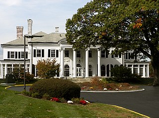
The Church of the Holy Trinity is an historic Episcopal church at 381 Main Street in Middletown, Connecticut. Completed in 1874, it is one of the city's finest examples of Gothic Revival architecture. Its nearby former rectory, also known as the Bishop Acheson House, is one of its finest Colonial Revival houses. The two buildings were listed on the National Register of Historic Places in 1979.

The Main Street Historic District in Danbury, Connecticut, United States, is the oldest section of that city, at its geographical center. It has long been the city's commercial core and downtown. Its 132 buildings, 97 of which are considered contributing properties, include government buildings, churches, commercial establishments and residences, all in a variety of architectural styles from the late 18th century to the early 20th. It is the only major industrial downtown of its size in Connecticut not to have developed around either port facilities or a water power site.

The Pomfret Street Historic District is a historic district roughly along Pomfret Street, from Bradley Road to Woodstock Road in Pomfret, Connecticut, United States. The district represents the core of the village of Pomfret Center.

The Black Rock Gardens Historic District is a historic district in the Black Rock neighborhood of Bridgeport, Connecticut. It encompasses a small residential development built between 1916 and 1920 to provide housing for workers in war-related industries in the city. It is a well-preserved example of one of several such developments made in the city with funding by the United States Housing Corporation, a government agency. The district was listed on the National Register of Historic Places in 1990.
The Prospect Hill Historic District is an irregularly-shaped 185-acre (75 ha) historic district in New Haven, Connecticut. The district encompasses most of the residential portion of the Prospect Hill neighborhood.

The Whitney Avenue Historic District is a historic district in the East Rock neighborhood of New Haven, Connecticut. It is a 203-acre (82 ha) district which included 1,084 contributing buildings when it was listed on the National Register of Historic Places in 1989.

The Drake Park Neighborhood Historic District is located adjacent to Drake Park near the historic downtown area in Bend, Oregon, United States. Because of the unique and varied architecture in the Drake Park neighborhood and its close association with the early development of the city of Bend, the area was listed on the National Register of Historic Places in 2005.

The Hatfield Center Historic District encompasses the traditional center of Hatfield, Massachusetts. The area, first laid out in 1661, is bounded by Maple Street to the south, the Connecticut River to the east, Day Avenue and School Street to the north, and the Mill River to the west. The area's layout and land use patterns are relatively little altered since they were laid out, leaving a well-preserved early colonial village landscape. The district was added to the National Register of Historic Places in 1994.
The Woodland Street Historic District is a historic housing district in the Main South area of Worcester, Massachusetts. It consists of 19 Victorian houses that either face or abut on Woodland Street, between Charlotte and Oberlin Streets. The district was listed on the National Register of Historic Places in 1980. Located directly adjacent to the campus of Clark University, some of the buildings are used by Clark for housing and administration.

Rosedale Park is a historic district located in Detroit, Michigan. It is roughly bounded by Lyndon, Outer Drive, Grand River Avenue, Southfield Freeway, Glastonbury Avenue, Lyndon Street and Westwood Drive. It was listed on the National Register of Historic Places in 2006. The Rosedale Park district has the largest number of individual properties of any district nominated to the National Register of Historic Places in Michigan, with 1533.
The Harriman Historic District is located in the northern section of Bristol, Pennsylvania, United States. It is a 17-acre (6.9 ha) residential area with 109 buildings, mostly houses, and the local secondary school.

The Beaver Hills Historic District is a 97-acre (39 ha) historic district in the Beaver Hills neighborhood of New Haven, Connecticut. It was listed on the National Register of Historic Places in 1986. In 1986, it included 235 contributing buildings.

The Lincoln Street Historic District in Brunswick, Maine, is an 8-acre (3.2 ha) historic district encompassing a remarkably uniform assemblage of mid 19th-century residential construction. It includes fourteen houses, most of which were built in a two-year period between 1843 and 1845. The district was listed on the National Register of Historic Places in 1976.

The McClellan Heights Historic District is a 188.2-acre (76.2 ha) historic district in Davenport, Iowa, United States. It was listed on the National Register of Historic Places in 1984, at which time it included 354 buildings deemed to contribute to the historic character of the area.

Lindbergh Forest is a neighborhood in Knoxville, Tennessee, United States, located off Chapman Highway (US-441) in South Knoxville, that is listed on the National Register of Historic Places as an historic district. Initially developed in the late 1920s as one of Knoxville's first automobile suburbs, the neighborhood is now noted for its late-1920s and early-1930s residential architecture, and the use of East Tennessee marble detailing. The neighborhood also contains two of Knoxville's five surviving Lustron houses. In 1998, several of its houses were added to the National Register of Historic Places as the Lindbergh Forest Historic District.

Oliver Johnson's Woods is a historic district and neighborhood on the northern side of Indianapolis, Indiana, United States. Located in southern Washington Township, the district occupies the site of what was once the family farm of Oliver Johnson. Born on the present site of the Indiana State Fairgrounds, Johnson grew up in a pioneer family that lived on the edge of the state capital city. Upon attaining adulthood, he bought property a short distance to the west, to which he moved in 1846. Here, he built a larger farmhouse in 1862, and he tilled the soil for most of the rest of his life. As Indianapolis grew northward, it reached the Johnson farm in the early twentieth century; the aged farmer and his sons saw the city's growth as an opportunity for financial gain, and in 1905 they announced the platting of 0.25 square miles (0.65 km2) of their property into individual lots. They chose an advantageous time to sell their property; as the new residents began to build their homes, an interurban railway was built along College Avenue on the district's western side that connected downtown with Broad Ripple. Many prosperous businessmen were attracted by the development's large lots and wooded streets; the city annexed Oliver Johnson's Woods in 1912, and by the outbreak of World War II, the streets were filled with large houses built in a wide variety of architectural styles. These early residents came from many different ethnicities: European immigrants were becoming more prosperous and leaving their ethnic enclaves, and new neighborhoods such as Oliver Johnson's Woods appealed to them. Among the neighborhood's leading residents was a colony of Jews of German descent.

The Bellows Falls Neighborhood Historic District encompasses a residential area of the village of Bellows Falls, Vermont. Located south of downtown Bellows Falls, the area has one of the largest concentrations of well-preserved 19th century residences in southern Vermont. It was listed on the National Register of Historic Places in 2002, and enlarged in 2007.

Historic Seaside Village Co-operative encompasses a primarily residential area in the South End of Bridgeport, Connecticut. It is bounded on the east by Iranistan Avenue, the north by South Avenue, the south by Forest Court and by the west by Alsace Street. The property consists of a densely built collection of brick rowhouses, arranged in irregular combinations. The village was developed during World War I to alleviate a housing shortage caused by an influx of workers hired to work in the city's munitions factories. It is a good example of an early government-funded project of this type, and was a collaborative design effort by R. Clipston Sturgis, Skinner & Walker, and Arthur Shurtleff. The district was listed on the National Register of Historic Places in 1990.
The Oxford-Whitney Streets District is a historic district encompassing an early-20th century residential area in the West End neighborhood of Hartford, Connecticut. It extends along the east side of Oxford Street between Elizabeth and Cone Streets, and along the west side of Whitney between Fern and Elizabeth, and includes the north side of Fern Street between Whitney and Oxford. Most of the housing, a combination of single and multi-family residences, was built between 1906 and 1919, a period later than the surrounding areas, and is predominantly Colonial Revival in character. It was listed on the National Register of Historic Places in 2010.

The Lakeview Village Historic District encompasses a historic World War I-era housing project on the east side of Bridgeport, Connecticut. Located northeast of Boston Avenue and west of Lakeview Cemetery, the development was built in 1918–20 to provide emergency housing for an influx of workers to the city's war production industries, and is a good early example of a Garden City movement subdivision. The district was listed on the National Register of Historic Places in 1990.


