{{native name|se|Vuogát}}"},"former_name":{"wt":"Vaagan herred"},"image_skyline":{"wt":"Lofoten Svolvear Fährhafen Ausfahrt.jpg"},"image_caption":{"wt":""},"idnumber":{"wt":"1865"},"county":{"wt":"Nordland"},"district":{"wt":"Lofoten"},"capital":{"wt":"[[Svolvær]]"},"preceded":{"wt":"none"},"established":{"wt":"1 Jan 1838"},"demonym":{"wt":"Vågaværing"},"language":{"wt":"Neutral"},"coatofarms":{"wt":"Vågan komm.svg"},"flag":{"wt":""},"webpage":{"wt":"www.vagan.kommune.no"},"mayor":{"wt":"Vidar Thom Benjaminsen"},"mayor_party":{"wt":"[[Conservative Party (Norway)|H]]"},"mayor_as_of":{"wt":"2023"},"elevation_max_m":{"wt":"1138.32"},"highest_point_ref":{"wt":"{{Cite web |date=2024-01-16 |title=Høgaste fjelltopp i kvar kommune |url=https://www.kartverket.no/til-lands/fakta-om-norge/hoyeste-fjelltopp-i-kommunen |publisher=[[Kartverket]] |language=no}}"},"area_rank":{"wt":"209"},"area_total_km2":{"wt":"479.18"},"area_land_km2":{"wt":"459.97"},"area_water_km2":{"wt":"19.21"},"area_water_percent":{"wt":"4"},"population_as_of":{"wt":"2024"},"population_rank":{"wt":"117"},"population_total":{"wt":"9793"},"population_density_km2":{"wt":"20.4"},"population_increase":{"wt":"6.2"},"coordinates":{"wt":"{{coord|68|16|41|N|14|31|15|E|region:NO|display=inline,title}}"}},"i":0}}]}" id="mwBg">Municipality in Nordland, Norway
Vågan Municipality Vågan kommune | |
---|---|
Vaagan herred (historic name) | |
![]() | |
![]() Nordland within Norway | |
![]() Vågan within Nordland | |
Coordinates: 68°16′41″N14°31′15″E / 68.27806°N 14.52083°E | |
Country | Norway |
County | Nordland |
District | Lofoten |
Established | 1 Jan 1838 |
• Created as | Formannskapsdistrikt |
Administrative centre | Svolvær |
Government | |
• Mayor (2023) | Vidar Thom Benjaminsen (H) |
Area | |
• Total | 479.18 km2 (185.01 sq mi) |
• Land | 459.97 km2 (177.60 sq mi) |
• Water | 19.21 km2 (7.42 sq mi) 4% |
• Rank | #209 in Norway |
Highest elevation | 1,138.32 m (3,734.65 ft) |
Population (2024) | |
• Total | 9,793 |
• Rank | #117 in Norway |
• Density | 20.4/km2 (53/sq mi) |
• Change (10 years) | ![]() |
Demonym | Vågaværing [2] |
Official language | |
• Norwegian form | Neutral |
Time zone | UTC+01:00 (CET) |
• Summer (DST) | UTC+02:00 (CEST) |
ISO 3166 code | NO-1865 [4] |
Website | Official website |
Vågan (Northern Sami : Vuogát) is a municipality in Nordland county, Norway. It is part of the traditional district of Lofoten. The administrative centre of the municipality is the town of Svolvær. Some of the villages in Vågan include Digermulen, Gimsøysand, Gravermarka, Henningsvær, Hopen, Kabelvåg, Kleppstad, Laupstad, Liland, Skrova, Straumnes, and Sydalen. [5]
The 479-square-kilometre (185 sq mi) municipality is the 209th largest by area out of the 357 municipalities in Norway. Vågan is the 117th most populous municipality in Norway with a population of 9,793. The municipality's population density is 20.4 inhabitants per square kilometre (53/sq mi) and its population has increased by 6.2% over the previous 10-year period. [6] [7]
Vågan was established as a municipality on 1 January 1838 (see formannskapsdistrikt law). In 1856, the northwestern part of Vågan Municipality (population: 987) was separated to form the new Gimsøy Municipality. On 1 July 1918, the town of Svolvær (population: 2,429) was separated to form its own municipality. This left Vågan with 3,399 residents. During the 1960s, there were many municipal mergers across Norway due to the work of the Schei Committee. On 1 January 1964, Gimsøy Municipality (population: 1,551), the town of Svolvær (population: 3,952), and Vågan Municipality (population: 4,820) were merged to form the new, larger Vågan Municipality. [8]
The municipality (originally the parish) is named after the old Vågan farm (Old Norse : Vágar) since the first Vågan Church was built there. The name is the plural form of vágr which means "bay" or "inlet". The island of Austvågøya (Old Norse : Vágøy) was named after this important site too (which later led the neighboring island to be named Vestvågøya). [9] On 21 December 1917, a royal resolution enacted the 1917 Norwegian language reforms. Prior to this change, the name was spelled Vaagan with the digraph "aa", and after this reform, the name was spelled Vågan, using the letter å instead. [10] [11]
The coat of arms was granted on 30 March 1973. The official blazon is "Azure, a cod embowed argent" (Norwegian : På blå bunn en vertikalstillet fremadbøyd sølv torsk). This means the arms have a blue field (background) and the charge is a cod. The cod has a tincture of argent which means it is commonly colored white, but if it is made out of metal, then silver is used. The blue color in the field and the code were chosen because fishing is the main source of income for the municipality. The arms were designed by Hallvard Traetteberg, basing them off the old arms for the town of Svolvær which was merged into Vågan in 1964. [12] [13] [14]
The Church of Norway has five parishes (sokn) within Vågan Municipality. It is part of the Lofoten prosti (deanery) in the Diocese of Sør-Hålogaland.
Parish (sokn) | Church name | Location of the church | Year built |
---|---|---|---|
Gimsøy og Strauman | Gimsøy Church | Gimsøysand | 1876 |
Strauman Church | Sydalen | 1984 | |
Henningsvær | Henningsvær Church | Henningsvær | 1974 |
Strandlandet | Strandlandet Church | Straumnes | 1938 |
Svolvær | Digermulen Church | Digermulen | 1951 |
Sildpollnes Church | Sildpollneset | 1891 | |
Svolvær Church | Svolvær | 1934 | |
Vågan | Vågan Church | Kabelvåg | 1898 |
The main population centres are the town of Svolvær and the villages of Kabelvåg and Henningsvær, located on the largest island, Austvågøya (although Svolvær and Henningsvær are partly located on smaller islands adjacent to the main island). All three have a picturesque situation under the rugged Lofoten mountains, facing the rough body of water called Vestfjorden. Vågan municipality includes over half of Austvågøya island, all of the islands of Gimsøya, Skrova, Stormolla, Litlmolla, numerous other tiny islets, plus the southwestern tip of the island of Hinnøya. The Moholmen Lighthouse and Skrova Lighthouse are both located in the Vestfjorden. The highest point in the municipality is the 1,138.32-metre (3,734.6 ft) tall mountain Higravtindan. [1] Other mountains include Svolværgeita, Fløya, Trakta, and Vågakallen.
Skrova near Svolvær has a temperate climate (marine west coast) in the 1991-2020 period.
Climate data for Skrova 1991-2020 (14 m, precipitation days 1961-90, extremes 1934-2022) | |||||||||||||
---|---|---|---|---|---|---|---|---|---|---|---|---|---|
Month | Jan | Feb | Mar | Apr | May | Jun | Jul | Aug | Sep | Oct | Nov | Dec | Year |
Record high °C (°F) | 10.6 (51.1) | 8.5 (47.3) | 10 (50) | 17.4 (63.3) | 24.3 (75.7) | 30.4 (86.7) | 29.8 (85.6) | 26.9 (80.4) | 22.1 (71.8) | 17.1 (62.8) | 13 (55) | 11.2 (52.2) | 30.4 (86.7) |
Mean daily maximum °C (°F) | 2.4 (36.3) | 1.6 (34.9) | 2.2 (36.0) | 4.8 (40.6) | 9 (48) | 13 (55) | 16.1 (61.0) | 15.4 (59.7) | 12 (54) | 7.8 (46.0) | 5.4 (41.7) | 3.6 (38.5) | 7.8 (46.0) |
Daily mean °C (°F) | 0.9 (33.6) | 0.2 (32.4) | 0.7 (33.3) | 3.1 (37.6) | 6.8 (44.2) | 10.6 (51.1) | 13.6 (56.5) | 13.3 (55.9) | 10.4 (50.7) | 6.5 (43.7) | 4 (39) | 2.2 (36.0) | 6.0 (42.8) |
Mean daily minimum °C (°F) | −1 (30) | −1.6 (29.1) | −0.9 (30.4) | 1.4 (34.5) | 4.9 (40.8) | 8.6 (47.5) | 11.5 (52.7) | 11.5 (52.7) | 8.8 (47.8) | 4.9 (40.8) | 2.2 (36.0) | 0.3 (32.5) | 4.2 (39.6) |
Record low °C (°F) | −12.7 (9.1) | −15.1 (4.8) | −12.3 (9.9) | −8.5 (16.7) | −3.4 (25.9) | −1.2 (29.8) | 3.7 (38.7) | 3.9 (39.0) | −1.4 (29.5) | −4.5 (23.9) | −10.7 (12.7) | −11.9 (10.6) | −15.1 (4.8) |
Average precipitation mm (inches) | 89 (3.5) | 81 (3.2) | 65 (2.6) | 49 (1.9) | 46 (1.8) | 37 (1.5) | 50 (2.0) | 48 (1.9) | 79 (3.1) | 88 (3.5) | 97 (3.8) | 90 (3.5) | 819 (32.3) |
Average precipitation days (≥ 1.0 mm) | 14 | 11 | 11 | 10 | 9 | 9 | 11 | 10 | 15 | 17 | 15 | 15 | 147 |
Source 1: Norwegian Meteorological Institute [15] | |||||||||||||
Source 2: Noaa WMO averages 91-2020 Norway [16] |
Climate data for Svolvær, Vågan 1961–1990 | |||||||||||||
---|---|---|---|---|---|---|---|---|---|---|---|---|---|
Month | Jan | Feb | Mar | Apr | May | Jun | Jul | Aug | Sep | Oct | Nov | Dec | Year |
Daily mean °C (°F) | −1.5 (29.3) | −1.8 (28.8) | −0.3 (31.5) | 2.2 (36.0) | 6.5 (43.7) | 10.1 (50.2) | 13.0 (55.4) | 13.0 (55.4) | 9.0 (48.2) | 5.2 (41.4) | 1.8 (35.2) | −0.5 (31.1) | 4.7 (40.5) |
Average precipitation mm (inches) | 159 (6.3) | 134 (5.3) | 112 (4.4) | 88 (3.5) | 63 (2.5) | 67 (2.6) | 87 (3.4) | 94 (3.7) | 146 (5.7) | 210 (8.3) | 160 (6.3) | 180 (7.1) | 1,500 (59.1) |
Source: Norwegian Meteorological Institute [17] |
Vågan Municipality is responsible for primary education (through 10th grade), outpatient health services, senior citizen services, welfare and other social services, zoning, economic development, and municipal roads and utilities. The municipality is governed by a municipal council of directly elected representatives. The mayor is indirectly elected by a vote of the municipal council. [18] The municipality is under the jurisdiction of the Salten og Lofoten District Court and the Hålogaland Court of Appeal.
The municipal council (Kommunestyre) of Vågan is made up of 29 representatives that are elected to four year terms. The tables below show the current and historical composition of the council by political party.
Party name (in Norwegian) | Number of representatives | |
---|---|---|
Labour Party (Arbeiderpartiet) | 5 | |
Progress Party (Fremskrittspartiet) | 3 | |
Green Party (Miljøpartiet De Grønne) | 1 | |
Conservative Party (Høyre) | 9 | |
Red Party (Rødt) | 2 | |
Centre Party (Senterpartiet) | 4 | |
Socialist Left Party (Sosialistisk Venstreparti) | 3 | |
Liberal Party (Venstre) | 2 | |
Total number of members: | 29 |
Party name (in Norwegian) | Number of representatives | |
---|---|---|
Labour Party (Arbeiderpartiet) | 7 | |
Progress Party (Fremskrittspartiet) | 1 | |
Green Party (Miljøpartiet De Grønne) | 1 | |
Conservative Party (Høyre) | 9 | |
Red Party (Rødt) | 2 | |
Centre Party (Senterpartiet) | 4 | |
Socialist Left Party (Sosialistisk Venstreparti) | 3 | |
Liberal Party (Venstre) | 2 | |
Total number of members: | 29 |
Party name (in Norwegian) | Number of representatives | |
---|---|---|
Labour Party (Arbeiderpartiet) | 8 | |
Progress Party (Fremskrittspartiet) | 2 | |
Conservative Party (Høyre) | 9 | |
Red Party (Rødt) | 3 | |
Centre Party (Senterpartiet) | 3 | |
Socialist Left Party (Sosialistisk Venstreparti) | 1 | |
Liberal Party (Venstre) | 3 | |
Total number of members: | 29 |
Party name (in Norwegian) | Number of representatives | |
---|---|---|
Labour Party (Arbeiderpartiet) | 12 | |
Progress Party (Fremskrittspartiet) | 3 | |
Conservative Party (Høyre) | 11 | |
Red Party (Rødt) | 2 | |
Centre Party (Senterpartiet) | 3 | |
Socialist Left Party (Sosialistisk Venstreparti) | 2 | |
Liberal Party (Venstre) | 2 | |
Total number of members: | 35 |
Party name (in Norwegian) | Number of representatives | |
---|---|---|
Labour Party (Arbeiderpartiet) | 12 | |
Progress Party (Fremskrittspartiet) | 5 | |
Conservative Party (Høyre) | 7 | |
Christian Democratic Party (Kristelig Folkeparti) | 1 | |
Coastal Party (Kystpartiet) | 1 | |
Red Electoral Alliance (Rød Valgallianse) | 3 | |
Centre Party (Senterpartiet) | 3 | |
Socialist Left Party (Sosialistisk Venstreparti) | 2 | |
Liberal Party (Venstre) | 1 | |
Total number of members: | 35 |
Party name (in Norwegian) | Number of representatives | |
---|---|---|
Labour Party (Arbeiderpartiet) | 10 | |
Progress Party (Fremskrittspartiet) | 5 | |
Conservative Party (Høyre) | 4 | |
Christian Democratic Party (Kristelig Folkeparti) | 1 | |
Coastal Party (Kystpartiet) | 4 | |
Red Electoral Alliance (Rød Valgallianse) | 3 | |
Centre Party (Senterpartiet) | 3 | |
Socialist Left Party (Sosialistisk Venstreparti) | 5 | |
Total number of members: | 35 |
Party name (in Norwegian) | Number of representatives | |
---|---|---|
Labour Party (Arbeiderpartiet) | 9 | |
Progress Party (Fremskrittspartiet) | 3 | |
Conservative Party (Høyre) | 7 | |
Christian Democratic Party (Kristelig Folkeparti) | 1 | |
Coastal Party (Kystpartiet) | 3 | |
Red Electoral Alliance (Rød Valgallianse) | 5 | |
Centre Party (Senterpartiet) | 6 | |
Vågan women's list (Vågan kvinneliste) | 1 | |
Total number of members: | 35 |
Party name (in Norwegian) | Number of representatives | |
---|---|---|
Labour Party (Arbeiderpartiet) | 14 | |
Conservative Party (Høyre) | 7 | |
Christian Democratic Party (Kristelig Folkeparti) | 1 | |
Red Electoral Alliance (Rød Valgallianse) | 2 | |
Centre Party (Senterpartiet) | 6 | |
Socialist Left Party (Sosialistisk Venstreparti) | 3 | |
Liberal Party (Venstre) | 2 | |
Total number of members: | 35 |
Party name (in Norwegian) | Number of representatives | |
---|---|---|
Labour Party (Arbeiderpartiet) | 20 | |
Progress Party (Fremskrittspartiet) | 1 | |
Conservative Party (Høyre) | 8 | |
Christian Democratic Party (Kristelig Folkeparti) | 1 | |
Red Electoral Alliance (Rød Valgallianse) | 2 | |
Centre Party (Senterpartiet) | 5 | |
Socialist Left Party (Sosialistisk Venstreparti) | 7 | |
Liberal Party (Venstre) | 1 | |
Total number of members: | 45 |
Party name (in Norwegian) | Number of representatives | |
---|---|---|
Labour Party (Arbeiderpartiet) | 20 | |
Progress Party (Fremskrittspartiet) | 3 | |
Conservative Party (Høyre) | 12 | |
Christian Democratic Party (Kristelig Folkeparti) | 1 | |
Red Electoral Alliance (Rød Valgallianse) | 1 | |
Centre Party (Senterpartiet) | 2 | |
Socialist Left Party (Sosialistisk Venstreparti) | 4 | |
Liberal Party (Venstre) | 2 | |
Total number of members: | 45 |
Party name (in Norwegian) | Number of representatives | |
---|---|---|
Labour Party (Arbeiderpartiet) | 20 | |
Progress Party (Fremskrittspartiet) | 1 | |
Conservative Party (Høyre) | 14 | |
Christian Democratic Party (Kristelig Folkeparti) | 2 | |
Centre Party (Senterpartiet) | 3 | |
Socialist Left Party (Sosialistisk Venstreparti) | 3 | |
Liberal Party (Venstre) | 2 | |
Total number of members: | 45 |
Party name (in Norwegian) | Number of representatives | |
---|---|---|
Labour Party (Arbeiderpartiet) | 16 | |
Conservative Party (Høyre) | 15 | |
Christian Democratic Party (Kristelig Folkeparti) | 3 | |
Red Electoral Alliance (Rød Valgallianse) | 1 | |
Centre Party (Senterpartiet) | 4 | |
Socialist Left Party (Sosialistisk Venstreparti) | 2 | |
Liberal Party (Venstre) | 2 | |
Vågan non-party list (Vågan upolitiske liste) | 2 | |
Total number of members: | 45 |
Party name (in Norwegian) | Number of representatives | |
---|---|---|
Labour Party (Arbeiderpartiet) | 18 | |
Conservative Party (Høyre) | 9 | |
Christian Democratic Party (Kristelig Folkeparti) | 3 | |
Centre Party (Senterpartiet) | 8 | |
Socialist Left Party (Sosialistisk Venstreparti) | 3 | |
Liberal Party (Venstre) | 3 | |
Svolvær Free Voters (Svolvær Frie Velgere) | 1 | |
Total number of members: | 45 |
Party name (in Norwegian) | Number of representatives | |
---|---|---|
Labour Party (Arbeiderpartiet) | 22 | |
Conservative Party (Høyre) | 6 | |
Christian Democratic Party (Kristelig Folkeparti) | 2 | |
Centre Party (Senterpartiet) | 6 | |
Liberal Party (Venstre) | 3 | |
Local List(s) (Lokale lister) | 6 | |
Total number of members: | 45 |
Party name (in Norwegian) | Number of representatives | |
---|---|---|
Labour Party (Arbeiderpartiet) | 24 | |
Conservative Party (Høyre) | 9 | |
Christian Democratic Party (Kristelig Folkeparti) | 2 | |
Centre Party (Senterpartiet) | 4 | |
Socialist People's Party (Sosialistisk Folkeparti) | 2 | |
Liberal Party (Venstre) | 5 | |
Local List(s) (Lokale lister) | 7 | |
Total number of members: | 53 |
Party name (in Norwegian) | Number of representatives | |
---|---|---|
Labour Party (Arbeiderpartiet) | 25 | |
Conservative Party (Høyre) | 10 | |
Christian Democratic Party (Kristelig Folkeparti) | 2 | |
Liberal Party (Venstre) | 8 | |
Local List(s) (Lokale lister) | 8 | |
Total number of members: | 53 | |
Note: On 1 January 1964, Gimsøy Municipality and the town of Svolvær became part of Vågan Municipality. |
Party name (in Norwegian) | Number of representatives | |
---|---|---|
Labour Party (Arbeiderpartiet) | 11 | |
Conservative Party (Høyre) | 6 | |
Liberal Party (Venstre) | 5 | |
Local List(s) (Lokale lister) | 3 | |
Total number of members: | 25 |
Party name (in Norwegian) | Number of representatives | |
---|---|---|
Labour Party (Arbeiderpartiet) | 11 | |
Communist Party (Kommunistiske Parti) | 1 | |
Liberal Party (Venstre) | 7 | |
Joint List(s) of Non-Socialist Parties (Borgerlige Felleslister) | 5 | |
Local List(s) (Lokale lister) | 1 | |
Total number of members: | 25 |
Party name (in Norwegian) | Number of representatives | |
---|---|---|
Labour Party (Arbeiderpartiet) | 7 | |
Conservative Party (Høyre) | 2 | |
Liberal Party (Venstre) | 5 | |
Local List(s) (Lokale lister) | 6 | |
Total number of members: | 20 |
Party name (in Norwegian) | Number of representatives | |
---|---|---|
Labour Party (Arbeiderpartiet) | 8 | |
Communist Party (Kommunistiske Parti) | 1 | |
Christian Democratic Party (Kristelig Folkeparti) | 1 | |
Joint list of the Liberal Party (Venstre) and the Radical People's Party (Radikale Folkepartiet) | 2 | |
Joint List(s) of Non-Socialist Parties (Borgerlige Felleslister) | 5 | |
Local List(s) (Lokale lister) | 3 | |
Total number of members: | 20 |
Party name (in Norwegian) | Number of representatives | |
---|---|---|
Labour Party (Arbeiderpartiet) | 9 | |
Communist Party (Kommunistiske Parti) | 2 | |
Christian Democratic Party (Kristelig Folkeparti) | 1 | |
Joint list of the Liberal Party (Venstre) and the Radical People's Party (Radikale Folkepartiet) | 1 | |
Joint List(s) of Non-Socialist Parties (Borgerlige Felleslister) | 4 | |
Local List(s) (Lokale lister) | 3 | |
Total number of members: | 20 |
Party name (in Norwegian) | Number of representatives | |
---|---|---|
Labour Party (Arbeiderpartiet) | 8 | |
List of workers, fishermen, and small farmholders (Arbeidere, fiskere, småbrukere liste) | 1 | |
Local List(s) (Lokale lister) | 11 | |
Total number of members: | 20 | |
Note: Due to the German occupation of Norway during World War II, no elections were held for new municipal councils until after the war ended in 1945. |
The mayor (Norwegian : ordfører) of Vågan is the political leader of the municipality and the chairperson of the municipal council. Here is a list of people who have held this position: [38] [39]
Kabelvåg is the oldest fishing village in Lofoten, where King Øystein built the first fishing shacks in the early 12th century. The Lofoten Cathedral, built in 1898, seats 1,200 people, and used to be filled to the last seat during the Lofoten fishing in the winter.
Henningsvær has a picturesque situation on several islands, and is today more important for fishing. Svolvær is the municipal centre, and has an impressive number of artists' studios and galleries. In addition to the cod fisheries, salmon fish farming and tourism are economically important in Vågan.
The islands that make up Vågan are connected by several different bridges. The European route E10 highway connects the neighboring Vestvågøy Municipality to Vågan Municipality (Gimsøya island) by the Sundklakkstraumen Bridge. Gimsøya island then connects to Austvågøya island by the Gimsøystraumen Bridge. The islands of Henningsvær are connected to Austvågøya by the Henningsvær Bridges. The rest of the small islands are only accessible by boats and ferries. In the town of Svolvær, the Svinøy Bridge connects the main part of town to the island of Svinøya. Svolvær Airport, Helle is located just east of the town of Svolvær.
Brønnøy is a municipality in Nordland county, Norway. It is part of the Helgeland region. The administrative centre and commercial centre of the municipality is the town of Brønnøysund. A secondary centre is the village of Hommelstø. Other villages include Tosbotnet, Lande, Trælnes, and Skomo.
Vevelstad is a municipality in Nordland county, Norway. It is part of the Helgeland traditional region. The administrative centre of the municipality is the village of Forvik. The municipality is relatively small and isolated, with no road connections to the rest of Norway. It is only accessible by ferry, despite much of the municipality being located on the mainland.
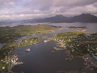
Herøy is a municipality in Nordland county, Norway. It is part of the Helgeland traditional region. The administrative centre of the municipality is the village of Silvalen. The island municipality is located about 15 kilometres (9.3 mi) west of the town of Sandnessjøen.
Leirfjord is a municipality in Nordland county, Norway. It is part of the Helgeland traditional region. The administrative centre of the municipality is the village of Leland. Other villages in Leirfjord include Bardal and Sundøya. The large Helgeland Bridge is partly located in the municipality, connecting it to Alstahaug Municipality and the town of Sandnessjøen.
Træna is a municipality in Nordland county, Norway. It is part of the Helgeland traditional region. The administrative centre of the municipality is the island/village of Husøya. Other population centres include Selvær and Sanna.
Gildeskål is a municipality in Nordland county, Norway. It is part of the Bodø Region and the traditional district of Salten. The administrative centre of the municipality is the village of Inndyr. Other villages include Forstranda, Lekanger, Mevik, Mårnes, Nygårdsjøen, Saura, Storvik, Sør-Arnøy, Sørfinnset, and Våg.
Beiarn is a municipality in Nordland county, Norway. It is part of the traditional district of Salten. Beiarn is also a part of the Bodø Region, a statistical metropolitan region. The administrative centre of the municipality is the village of Moldjord. Other villages in Beiarn are Høyforsmoen, Trones, and Tverrvika.
Steigen is a municipality in Nordland county, Norway. It is part of the traditional district of Salten. The administrative centre of the municipality is the village of Leinesfjorden. Other villages include Leirvikbogen, Leines, Nordfold, Nordskot, and Sørskot. Engeløy Airport, Grådussan is located in the northern part of the municipality. Måløy–Skarholmen Lighthouse is located in the Vestfjorden in the western part of the municipality. The only road access to the municipality is via the Steigen Tunnel.
Hamarøy (Norwegian) or Hábmer (Lule Sami) is a municipality in Nordland county, Norway. It is part of the traditional district of Salten. The administrative centre of the municipality is the village of Oppeid. Other villages include Drag, Hellmobotn, Innhavet, Karlsøy, Korsnes, Presteid, Skutvika, Tømmerneset, Tranøya, and Ulvsvåg.
Lødingen is a municipality in Nordland county in Norway. Lødingen is located on the southeastern corner of the island of Hinnøya, and is part of the traditional district of Ofoten. The administrative centre of the municipality is the village of Lødingen. Other villages in the municipality include Våge and Ytterstad. Lødingen has the nickname "Biketown" because it hosts several annual bicycle races, including "Lofoten Insomnia" and Vestbygd-rittet.
Tjeldsund (Norwegian) or Dielddanuorri (Northern Sami) is a municipality in Troms county, Norway. The southwestern part of the municipality is part of the traditional district of Ofoten and the rest of the municipality is part of Central Hålogaland. The administrative centre of the municipality is the village of Evenskjer. Other important villages include Boltåsen, Fjelldal, Grov, Myklebostad, Ramsund, Renså, Sandstrand, and Tovika. Norges Brannskole is situated in Fjelldal. Marinejegerkommandoen is based south of Ramsund.
Røst is a small island municipality in Nordland county, Norway. It is part of the traditional district of Lofoten. The administrative centre of the municipality is the village of Røstlandet on the island of Røstlandet.
Værøy is an island municipality in Nordland county, Norway. It is part of the traditional district of Lofoten. The administrative centre of the municipality is the village of Sørland on the main island of Værøya. The other village in Værøy is Nordland. Most of the residents live in the Sørland area surrounding the main harbor. The old Værøy Lighthouse sits at the end of that harbor.
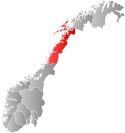
Flakstad is a municipality in Nordland county, Norway. It is part of the traditional district of the island group Lofoten. The administrative centre of the municipality is the village of Ramberg. Other villages in the municipality include Fredvang, Napp, Nusfjord, Sund, and Vareid.
Vestvågøy is a municipality in Nordland county, Norway. It is part of the traditional district of Lofoten. The administrative centre of the municipality is the town of Leknes. Some of the villages in the municipality include Ballstad, Borg, Bøstad, Gravdal, Knutstad, Stamsund, Tangstad, and Valberg. With over 11,600 inhabitants, Vestvågøy is the most populous municipality in all of the Lofoten and Vesterålen regions in Nordland county.
Hadsel is a municipality in Nordland county, Norway. It is part of the traditional district of Vesterålen. The administrative centre of the municipality is the town of Stokmarknes. Some of the main villages in Hadsel include Fiskebøl, Jarstad, Grønning, Grytting, Hanøyvika, Hennes, Kaldjorda, Melbu, Sanden, and Sandnes.
Moskenes is a municipality in Nordland county, Norway. The municipality comprises the southern part of the island of Moskenesøya in the traditional district of Lofoten. The administrative centre of the municipality is the village of Reine. Other villages include Sørvågen, Hamnøya, and Å.
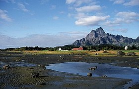
Svolvær, Suolvearra (Northern Sami), or Spålavuolle (Lule Sami) is a town and the administrative centre of Vågan Municipality in Nordland County, Norway. It is located on the island of Austvågøya in the Lofoten archipelago, along the Vestfjorden. The 2.36-square-kilometre (580-acre) town has a population (2023) of 4,736 and a population density of 2,007 inhabitants per square kilometre (5,200/sq mi).
Valberg is a former municipality in Nordland county, Norway. The 57-square-kilometre (22 sq mi) municipality existed from 1927 until 1963. The municipality covered the southeastern coast of the island of Vestvågøya in what is now Vestvågøy Municipality. The administrative centre was the village of Valberg where Valberg Church is located.
Gimsøy is a former municipality in Nordland county, Norway. The 186.5-square-kilometre (72.0 sq mi) municipality existed from 1856 until its dissolution in 1964. It was located in the northwestern part of what is now Vågan Municipality. The municipality consisted of the island of Gimsøya and the northwestern part of the larger neighboring island of Austvågøya. The municipality also included 407 other small islands as well as hundreds of little islets and skerries, all of which are located in the Lofoten archipelago. The administrative centre was located at the village of Gimsøysand, where the Gimsøy Church is located.
{{cite web}}
: CS1 maint: archived copy as title (link)