
The Natural Bridge Caverns are the largest known commercial caverns in the U.S. state of Texas. The name is derived from the 60 ft natural limestone slab bridge that spans the amphitheater setting of the cavern's entrance. The span was left suspended when a sinkhole collapsed below it.

The Hoosac Tunnel is a 4.75-mile (7.64 km) active railroad tunnel in western Massachusetts that passes through the Hoosac Range, an extension of Vermont's Green Mountains. It runs in a straight line from its east portal, along the Deerfield River in the town of Florida, to its west portal in the city of North Adams.

The Grave Creek Mound in the Ohio River Valley in West Virginia is one of the largest conical-type burial mounds in the United States, now standing 62 feet (19 m) high and 240 feet (73 m) in diameter. The builders of the site, members of the Adena culture, moved more than 60,000 tons of dirt to create it about 250–150 BC.
Newton Upper Falls is one of the thirteen villages within the city of Newton in Middlesex County, Massachusetts, United States.

The Cliffs Shaft Mine Museum is a former iron mine, now a heritage museum, located on Euclid Street between Lakeshore Drive and Spruce Street in Ishpeming, Michigan. The museum, operated by "Marquette Range Iron Mining Heritage Theme Park Inc.", celebrates the history of the Marquette Iron Range. The site was designated a state of Michigan historic site in 1973 and placed on the National Register of Historic Places in 1992.

The Holyoke Canal System is a system of power canals in Holyoke, Massachusetts. It is split into three canals based on elevation and distance from the inlet at the Holyoke Dam- the First Level Canal, Second Level Canal, and Third Level Canal. Constructed over a period between 1847 and 1892, the Canal System, along with the Dam, is recognized as a Historic Mechanical Engineering Landmark by the American Society of Mechanical Engineers for its use in the development of the Venturi meter by Clemens Herschel, the first means of measuring large-scale flows, and the McCormick-Holyoke Turbine by John B. McCormick, which doubled the efficiency of turbines to more than 80% in its time.
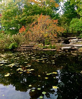
The Alfred Caldwell Lily Pool, also known as Lincoln Park Lily Pool, is an important example of Prairie School landscape architecture designed by Alfred Caldwell and located at 125 W. Fullerton Parkway in Lincoln Park, Chicago, Illinois. Developed in 1936-38, it is one of Caldwell's most fully realized designs. It was designated a Chicago Landmark on November 6, 2002. It was listed on the National Register of Historic Places and as a National Historic Landmark on February 17, 2006.

The San Jacinto Battleground State Historic Site includes the location of the Battle of San Jacinto and the museum ship USS Texas. It is located off the Houston Ship Channel in unincorporated Harris County, Texas near the city of Houston. The site was designated a National Historic Landmark in 1960.

Tower Hill State Park is a state park of Wisconsin, United States, which contains the reconstructed Helena Shot Tower. The original shot tower was completed in 1832 and manufactured lead shot until 1860. It was added to the National Register of Historic Places in 1973. The park abuts the Wisconsin River and is bordered by state-owned land comprising the Lower Wisconsin State Riverway.

The Bailey Farm Windmill is an historic windmill on Maine State Route 16, north of the village of North Anson, Maine. Built in 1905, it is an architecturally distinctive local landmark, with an octagonal frame and a copper-domed roof. It was listed on the National Register of Historic Places in 1988.
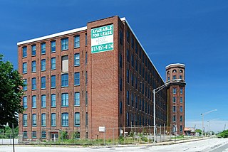
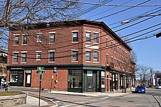
Mechanics Mill is an historic cotton textile mill located at 1082 Davol Street in Fall River, Massachusetts.

The Foxborough Pumping Station is a historic water pumping station at 25 Pumping Station Road in Foxborough, Massachusetts. Its main pumphouse was designed by Ernest Boyden, a regionally known architect of water supply systems, and was built in 1891; it is a brick structure with Queen Anne styling. The station also includes several historic wells, a period garage, and the man-made Fales Pond, a once-dammed section of the Neponset Reservoir near the pumphouse. The station was listed on the National Register of Historic Places in 2005.

The Bisbee Mill is a historic gristmill at 66 East Street in Chesterfield, Massachusetts. Located on the Dead Branch of the Westfield River, the mill complex includes a wood frame mill building, along with its former mill pond, impounded by a dam across the river, and a canal that brought river water to the mill for power. Also included on the property is the site of the Damon sawmill, which was established in 1761, and the Pierce cornmill, which occupied a site north of the Bisbee mill building in 1823. The Pierce mill was moved to the site, from an earlier one that may also be on the grounds of the Bisbee mill complex.

Alaska Central Railroad Tunnel No. 1, also known as the Loop District Tunnel No. 1 is a historic railroad tunnel located about 40 miles (64 km) north of Seward, Alaska, in the Placer River Valley, Kenai Peninsula. The tunnel was dug in 1906 and served the Alaska Central Railroad and later the Alaska Railroad until the route in the area, known as the "Loop District" was rerouted in 1951.

The Crow Creek Water Ditch is a historic water transportation system which brought water from Eureka Creek to where it was needed in gold placer mining in the Indian Creek drainage area where gold was discovered in 1866. It is located near Townsend, Montana. It was built between 1866 and c.1875 originally to support gold mining, which required water, then later was used for farm and ranch irrigation.
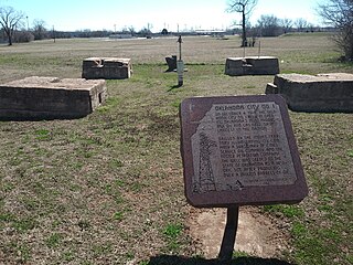
The Oklahoma City Discovery Well was the first successful oil well to be drilled in Oklahoma City, Oklahoma. The December 4, 1928 discovery opened the Oklahoma City Oil Field to extensive exploitation, creating an oil boom that sustained the area through the Great Depression. Because much of the oil was under the existing city, the Oklahoma City field pioneered the use of directional drilling to allow lateral displacement of well bores to reach deposits under developed areas.

The Kregel Wind Mill Company produced water pumping windmills in Nebraska City, Nebraska starting in 1879. It is now the Kregel Windmill Factory Museum.
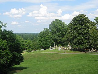
The Helena Confederate Cemetery is located in the southwest corner of the Maple Hill Cemetery on Holly Street in Helena, Arkansas. It is a small section of the larger cemetery, under one acre in size, and is marked by two significant memorials: the Confederate Memorial and the memorial to Confederate Army General Patrick Cleburne, whose burial here is the only known place associated with his life. The Cleburne memorial is a marble shaft 15 feet (4.6 m) in height, topped by an urn with flames coming from its top. The Confederate Memorial is a marble depiction of a soldier, mounted on a 30-foot (9.1 m) granite shaft, surrounded by pyramids of cannonballs and inverted cannons. The cemetery has more than 100 marked graves, 15 of which are unidentified Confederate dead, and 23 are of those killed in the 1863 Battle of Helena.

The Snoqualmie Falls Hydroelectric Plant is located just north of Snoqualmie in King County, Washington state, US. It is situated about 22 mi (35 km) east of Seattle. Located just below the Snoqualmie Falls, the power plant consists of two power houses, Plant 1 and Plant 2. Plant 1 was completed in 1899 and is located underground. It is the first completely underground hydroelectric power plant ever built in the world. Plant 2 was built in 1910 and is located along the right bank of the Snoqualmie River. Both plants receive water from a small reservoir created by a weir atop the falls. Plant 1 has an installed capacity of 13.7 MW and Plant 2 a capacity of 40.2 MW for a total installed capacity of 53.9 MW, enough to power 40,000 homes.
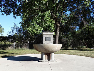
The Southeast Water Trough is an historic structure located in Des Moines, Iowa, United States. It is one of the last of 15 National Humane Alliance fountains that were placed around the city by the Iowa Humane Alliance. They were also named Ensign fountains after the founder of the National Humane Alliance, Hermon Lee Ensign. This was one of two placed in Des Moines in 1906.

