Wayland, Michigan | |
---|---|
Coordinates: 42°40′28″N85°38′44″W / 42.67444°N 85.64556°W | |
Country | United States |
State | Michigan |
County | Allegan |
Area | |
• Total | 3.01 sq mi (7.79 km2) |
• Land | 2.96 sq mi (7.67 km2) |
• Water | 0.04 sq mi (0.12 km2) |
Elevation | 420 ft (69 m) |
Population (2020) | |
• Total | 4,435 |
• Density | 1,497.30/sq mi (578.05/km2) |
Time zone | UTC-5 (Eastern (EST)) |
• Summer (DST) | UTC-4 (EDT) |
ZIP code | 49348 |
Area code | 269 |
FIPS code | 26-84880 [2] |
GNIS feature ID | 1615899 [3] |
Website | www |
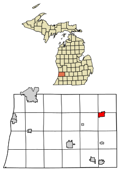
Wayland is a city in Allegan County in the U.S. state of Michigan. The population was 4,435 at the 2020 census. [4]
The city is located at the northwest corner of Wayland Township, but is politically independent. The city has also incorporated a portion of land in the south of adjacent Leighton Township. U.S. Route 131 forms the western boundary of the city. The city is home to OpenRoad Brewery, as well as several local restaurants and businesses.
About two hundred years ago, the area now known as Wayland, Michigan was inhabited by the Match-E-Be-Nash-She-Wish Band of the Pottawatomi, a Native American tribe in Michigan. The tribe lived in settled villages, hunted game, and farmed and harvested corn and wild rice, in addition to making maple sugar tree sap. The tribe is federally recognized and is headquartered in nearby Wayland Township. It owns the Gun Lake Casino, opened in 2011. [5]
The area began changing under pressure of European-American development. By 1826 the land had been surveyed for settlement in United States style. Colonel Isaac Barnes, attracted by the extensive forests of pine and hardwoods, purchased a tract of land along the Rabbit River and began operating a mill producing lumber and wooden shingles, giving the area its first name, Lumberton. [6]
In 1837, the Barnes family arrived and began clearing the land for farming, and by the 1840s, several more families had settled in the area. This growth brought enough children to the area to justify building the first American-style school in 1844.
In 1855 a road was built to connect the two larger towns of Grand Rapids and Kalamazoo, running directly through Chamber's Corners, the main intersection in the city. This area is now known by that name. This busy road led to increased commerce, and business in the form of dairy farms and factories, which led to further growth over time.
The area was officially named Wayland in 1868 after a town in New York, as many migrants had come from that state.
According to the United States Census Bureau, the city has a total area of 3.03 square miles (7.85 km2), of which 2.98 square miles (7.72 km2) is land and 0.05 square miles (0.13 km2) is water. [7]
Census | Pop. | Note | %± |
---|---|---|---|
1870 | 585 | — | |
1880 | 546 | −6.7% | |
1890 | 523 | −4.2% | |
1900 | 619 | 18.4% | |
1910 | 725 | 17.1% | |
1920 | 853 | 17.7% | |
1930 | 1,013 | 18.8% | |
1940 | 1,005 | −0.8% | |
1950 | 1,591 | 58.3% | |
1960 | 2,019 | 26.9% | |
1970 | 2,054 | 1.7% | |
1980 | 2,023 | −1.5% | |
1990 | 2,751 | 36.0% | |
2000 | 3,939 | 43.2% | |
2010 | 4,079 | 3.6% | |
2020 | 4,435 | 8.7% | |
U.S. Decennial Census [8] |
As of the census [9] of 2010, there were 4,079 people, 1,555 households, and 1,051 families residing in the city. The population density was 1,368.8 inhabitants per square mile (528.5/km2). There were 1,751 housing units at an average density of 587.6 per square mile (226.9/km2). The racial makeup of the city was 95.0% White, 0.3% African American, 0.8% Native American, 0.3% Asian, 0.9% from other races, and 2.6% from two or more races. Hispanic or Latino of any race were 3.9% of the population.
There were 1,555 households, of which 40.1% had children under the age of 18 living with them, 45.4% were married couples living together, 16.5% had a female householder with no husband present, 5.7% had a male householder with no wife present, and 32.4% were non-families. 25.2% of all households were made up of individuals, and 8.9% had someone living alone who was 65 years of age or older. The average household size was 2.56 and the average family size was 3.04.
The median age in the city was 33.3 years. 28.7% of residents were under the age of 18; 10% were between the ages of 18 and 24; 26.6% were from 25 to 44; 23.1% were from 45 to 64; and 11.7% were 65 years of age or older. The gender makeup of the city was 47.0% male and 53.0% female.
As of the census [2] of 2000, there were 3,939 people, 1,466 households, and 1,027 families residing in the city. The population density was 1,363.8 inhabitants per square mile (526.6/km2). There were 1,591 housing units at an average density of 550.8 per square mile (212.7/km2). The racial makeup of the city was 96.75% White, 0.63% African American, 0.91% Native American, 0.15% Asian, 0.05% Pacific Islander, 0.63% from other races, and 0.86% from two or more races. Hispanic or Latino of any race were 2.08% of the population.
There were 1,466 households, out of which 41.2% had children under the age of 18 living with them, 53.6% were married couples living together, 12.6% had a female householder with no husband present, and 29.9% were non-families. 23.7% of all households were made up of individuals, and 9.5% had someone living alone who was 65 years of age or older. The average household size was 2.61 and the average family size was 3.11.
In the city, the population was spread out, with 30.4% under the age of 18, 10.6% from 18 to 24, 33.2% from 25 to 44, 14.6% from 45 to 64, and 11.2% who were 65 years of age or older. The median age was 31 years. For every 100 females, there were 90.5 males. For every 100 females age 18 and over, there were 83.2 males.
The median income for a household in the city was $41,852, and the median income for a family was $50,298. Males had a median income of $35,811 versus $25,786 for females. The per capita income for the city was $18,077. About 6.7% of families and 7.9% of the population were below the poverty line, including 8.6% of those under age 18 and 8.9% of those age 65 or over.
K-12 public education is provided by Wayland Union Schools.
US 131 runs north–south through the city, linking with Kalamazoo to the south and Grand Rapids to the north
Thawville is a village in Ridgeland Township, Iroquois County, Illinois, United States. The population was 215 at the 2020 census. The town is 100 miles (160 km) south of Chicago.
Edgewood is a city in Clayton and Delaware counties in the U.S. state of Iowa. Highway 3, which runs through the center of town, is the dividing line between the two counties. The Edgewood post office was established in 1852 on the Clayton side of the town. Edgewood was formally incorporated in 1892, although it had a functioning council for some time before that date. The population was 909 at the time of the 2020 census, down from 923 in 2000.
Wayland is a village in Jefferson Township, Henry County, Iowa, United States. The population was 964 at the time of the 2020 census.
Wayland is a home rule-class city in Floyd County, Kentucky, United States. The population was 426 at the 2010 census, up from 298 at the 2000 census.
Hopkins Township is a civil township of Allegan County in the U.S. state of Michigan. The population was 2,760 at the 2020 census. The township is named after Stephen Hopkins, a signer of the Declaration of Independence.
Wayland Township is a civil township of Allegan County in the U.S. state of Michigan. The population was 3,573 at the 2020 census.
Essexville is a city in Bay County in the U.S. state of Michigan. The population was 3,379 at the 2020 census. Located along the Saginaw River, Essexville is part of the Saginaw, Midland, and Bay City metropolitan area.
Bridgman is a city in Berrien County in the U.S. state of Michigan. The population was 2,096 at the time of the 2020 census.
Wells Township is a civil township of Delta County in the U.S. state of Michigan. The population was 4,876 at the 2020 census, slightly down from 4,885 at the 2010 census.
Norway is a city in Dickinson County in the U.S. state of Michigan. The population was 2,840 at the 2020 census. It is part of the Iron Mountain, MI–WI micropolitan statistical area.
Little Traverse Township is a civil township of Emmet County in the U.S. state of Michigan. The population was 2,657 at the 2020 census.
Petersburg is a city in Monroe County in the U.S. state of Michigan. The population was 1,171 at the 2020 census.
Keego Harbor is a city in Oakland County in the U.S. state of Michigan. A northern suburb of Detroit, Keego Harbor is located roughly 27 miles (43.5 km) from downtown Detroit, and about 3 miles (4.8 km) southwest of Pontiac. As of the 2010 census, the city had a population of 2,970. With a land area of 0.50 square miles (1.29 km2), Keego Harbor is the third-smallest city by land area in the state of Michigan, after Petersburg and Clarkston.
Laingsburg is a city in Shiawassee County in the U.S. state of Michigan. The population was 1,424 at the 2020 census.
Buckley is a village in Wexford County in the U.S. state of Michigan. The population was 775 at the 2020 census, an increase from 697 at the 2010 census. The village is located within Hanover Township, and lies immediately south of the Grand Traverse County line. The village lies about 6.5 miles (10.5 km) north of Mesick, about 20 miles (32 km) northwest of Cadillac, and about 15 miles (24 km) south of Traverse City.
Wayland is a city in Clark County, Missouri, United States. As of the 2020 census, its population was 408. It is part of the Fort Madison–Keokuk, IA-MO Micropolitan Statistical Area.
Galeton is a borough in Potter County, Pennsylvania. It is located 50 miles (80 km) southeast of Bradford, Pennsylvania. Light industries, including knitting mills and a tannery have existed in Galeton. The population declined to 993 people in 2020.
Dark River is an unorganized territory in Saint Louis County, Minnesota, United States, located north of Chisholm and Balkan Township. The population was 68 at the 2000 census.
Wayland is a town in Steuben County, New York, United States. The population was 3,733 at the 2020 census.
Fairchild is a town in Eau Claire County, Wisconsin, United States. The population was 351 at the 2000 census. The Village of Fairchild is located within the town.