West Albany, Minnesota

Last updated
West Albany
USA Minnesota location map.svg
Red pog.svg
West Albany
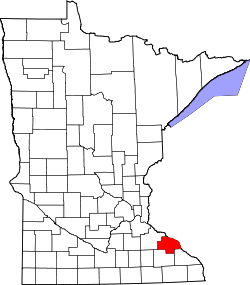
Location of the community of West Albany
within West Albany Township, Wabasha County
Usa edcp location map.svg
Red pog.svg
West Albany
West Albany (the United States)
Coordinates: 44°18′05″N92°17′08″W / 44.30139°N 92.28556°W / 44.30139; -92.28556 Coordinates: 44°18′05″N92°17′08″W / 44.30139°N 92.28556°W / 44.30139; -92.28556
Country United States
State Minnesota
County Wabasha County
Township West Albany Township
Elevation
820 ft (250 m)
Time zone UTC-6 (Central (CST))
  Summer (DST) UTC-5 (CDT)
ZIP code
55041 and 55957
Area code(s) 507
GNIS feature ID655003 [1]

West Albany is an unincorporated community in West Albany Township, Wabasha County, Minnesota, United States.

Contents

Geography

The community is located between Zumbro Falls and Wabasha along State Highway 60 (MN 60) near the intersection with 310th Avenue. Spring Creek and West Albany Creek meet at West Albany. The Zumbro River is nearby. Nearby places include Millville, Lake City, Zumbro Falls, Theilman, and Wabasha.

History

West Albany was platted in 1857, and named after Albany, New York, the native home of a large share of the first settlers. [2] A post office called West Albany was established in 1857, and remained in operation until 1881. [3]

Related Research Articles

Wabasha County, Minnesota U.S. county in Minnesota

Wabasha County is a county in the U.S. state of Minnesota. As of the 2010 United States Census, the population was 21,676. Its county seat is Wabasha.

Olmsted County, Minnesota county in Minnesota, USA

Olmsted County is a county in the U.S. state of Minnesota. As of the 2010 census, the population was 144,248, and has an estimated population of 158,293 as of 2019. Its county seat and largest city is Rochester.

Goodhue County, Minnesota County in the United States

Goodhue County is a county in the U.S. state of Minnesota. As of the 2010 census, the population was 46,183. Its county seat is Red Wing. Nearly all of Prairie Island Indian Community is within the county.

Zumbro Township, Wabasha County, Minnesota Township in Minnesota, United States

Zumbro Township is a township in Wabasha County, Minnesota, United States. The population was 715 at the 2000 census. The unincorporated community of South Troy is in Zumbro Township.
Zumbro Falls, Minnesota City in Minnesota, United States

Zumbro Falls is a city along the Zumbro River in Wabasha County, Minnesota, United States. The population was 207 at the 2010 census. U.S. Highway 63 and Minnesota 60 intersect in Zumbro Falls.

Zumbro River river in the United States of America

The Zumbro River is a tributary of the Mississippi River in the Driftless Area of southeastern Minnesota in the United States. It is 64.6 miles (104.0 km) long from the confluence of its principal tributaries and drains a watershed of 1,428 square miles (3,700 km2). The river's name in English is a change from its French name Rivière des Embarras due to its mouth located near Pine Island in the Mississippi River; the pronunciation changed from [dez‿ɑ̃.ba.ʁɑ] to. The Dakota name for this river is Wapka Wazi Oju, having reference to the grove of great white pines at Pine Island.

Weaver, Minnesota Unincorporated community in Minnesota, United States

Weaver is an unincorporated community in Minneiska Township, Wabasha County, Minnesota, United States. The Whitewater River and the Mississippi River meet at Weaver.

Lake Zumbro Hydroelectric Generating Plant United States historic place

The Lake Zumbro Hydroelectric Generating Plant, also known as the City of Rochester Municipal Hydro-Electric Plant, is a hydroelectric facility on the Zumbro River in Mazeppa and Zumbro Townships, Wabasha County, Minnesota, United States. The facility consists of a gravity dam and a powerhouse, and the impoundment created is called Lake Zumbro. This dam spans 440 feet (130 m) and is 60 feet (18 m) high, creating a reservoir with about 55 feet (17 m) of hydraulic head. The facility was designed by pioneering hydroelectric engineer Hugh Lincoln Cooper (1865–1937) and was built from 1917 to 1919. It is still operated by its original owner, Rochester Public Utilities (RPU), to supply power to Rochester, Minnesota, 15 miles (24 km) to the south. The Lake Zumbro Hydroelectric Generating Plant was listed on the National Register of Historic Places in 1991 for having state-level significance in the theme of engineering. It was nominated as a representative work of Cooper—one of the nation's leading hydroelectric engineers in the early 20th century—and his only project in his home state of Minnesota.

South Troy, Minnesota Unincorporated community in Minnesota, United States

South Troy is an unincorporated community in Zumbro Township, Wabasha County, Minnesota, United States. It is located on U.S. Highway 63 about 13 miles north of Rochester. Nearby places include Hammond, Zumbro Falls, Mazeppa, Potsdam, and Oronoco. Wabasha County Roads 7 and 11 are nearby.

Bridge 5827 bridge in United States of America

Bridge 5827 is a historic arch bridge in Zumbro Falls, Minnesota, United States, built in 1938 by the Works Progress Administration using a modular corrugated iron product called Multi Plate. It was listed on the National Register of Historic Places as the Bridge No. 5827–Zumbro Falls in 1998 for having state-level significance in the theme of engineering. It was nominated as an example of Minnesota's stone-faced Multi Plate bridges with particularly fine masonry.

Richard J. Dorer Memorial Hardwood State Forest

The Richard J. Dorer Memorial Hardwood State Forest is a 1,016,204 acres (4,112.43 km2) reserve of current and former forest in Minnesota's Driftless Area. Only 45,000 acres (180 km2) of the land is state owned, with the remainder owned by private individuals and community groups, governed by easements. Non-contiguous units are spread over seven counties, generally in areas just west of the Mississippi River, but extending much further west into the valleys of the Root and Zumbro Rivers.

Rochester metropolitan area, Minnesota Metropolitan area in the United States

The United States Census Bureau defines the Rochester, Minnesota Metropolitan Statistical Area (MSA) as an area consisting of four counties in southeast Minnesota, anchored by the city of Rochester. As of 2018, the US Census Bureau estimates that the Rochester metropolitan statistical area has a population of 219,802. The Rochester–Austin combined statistical area has a population of 259,813 as of 2018.

Maple Springs, Minnesota Unincorporated community in Minnesota, United States

Maple Springs is an unincorporated community in Pepin Township, Wabasha County, Minnesota, United States, along the Mississippi River and Lake Pepin. The Mississippi River and King Creek meet at Maple Springs.

Reads Landing, Minnesota Unincorporated community in Minnesota, United States

Reads Landing is an unincorporated community in Pepin Township, Wabasha County, Minnesota, United States, along the Mississippi River.

Oak Center, Minnesota Unincorporated community in Minnesota, United States

Oak Center is an unincorporated community in Gillford Township, Wabasha County, Minnesota, United States.

Theilman, Minnesota Unincorporated community in Minnesota, United States

Theilman is an unincorporated community in Wabasha County, Minnesota, United States.

Jarrett, Minnesota Unincorporated community in Minnesota, United States

Jarrett is an unincorporated community in Wabasha County, Minnesota, United States.

Dumfries, Minnesota Unincorporated community in Minnesota, United States

Dumfries is an unincorporated community in Glasgow Township, Wabasha County, Minnesota, United States.

Bear Valley, Minnesota Unincorporated community in Minnesota, United States

Bear Valley is an unincorporated community in Chester Township, Wabasha County, Minnesota, United States.

Wasioja, Minnesota Unincorporated community in Minnesota, United States

Wasioja is an unincorporated community in Wasioja Township, Dodge County, Minnesota, United States. The community is located near the junction of Dodge County Roads 9 and 16. The South Branch Middle Fork of the Zumbro River and Dodge Center Creek meet at Wasioja. Nearby places include Dodge Center, Mantorville, and Kasson.

References

  1. "West Albany, Minnesota". Geographic Names Information System . United States Geological Survey.
  2. Upham, Warren (1920). Minnesota Geographic Names: Their Origin and Historic Significance. Minnesota Historical Society. p.  559.
  3. "Wabasha County". Jim Forte Postal History. Retrieved 10 August 2015.