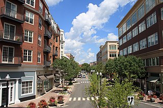
Edgewood Historic District is a historic district located in the west-central portion of New Haven, Connecticut. It was listed on the National Register of Historic Places in 1986. A predominantly residential area roughly bisected by Edgewood Avenue, a broad boulevard which features a large central esplanade and forms the principal east-west artery through the heart of the district. The area includes 232 contributing buildings, 4 other contributing structures, and 1 contributing object. Most of these were built between about 1888 and 1900, and represent the city's first neighborhood planned under the tenets of the City Beautiful movement. They are generally either Queen Anne or Colonial Revival in style, and are set on larger lots.

The Old Dauphin Way Historic District is a historic district in the city of Mobile, Alabama, United States. It was named for Dauphin Way, now known as Dauphin Street, which bisects the center of the district from east to west. The district is roughly bounded by Broad Street on the east, Springhill Avenue on the north, Government Street on the south, and Houston Avenue on the west. Covering 766 acres (3.10 km2) and containing 1466 contributing buildings, Old Dauphin Way is the largest historic district in Mobile.

Prospect Hill is a neighborhood of the city of New Haven, Connecticut located in the north central portion of the city, directly north of Downtown New Haven. The neighborhood contains residences, institutional buildings of Albertus Magnus University and a portion of the main campus of Yale University, including the Science Hill area, the Hillhouse Avenue area and the Yale Peabody Museum. The City of New Haven defines the neighborhood to be the region bounded by the town of Hamden in the north, Winchester Avenue in the west, Munson Street/Hillside Place/Prospect Street in the southwest, Trumbull Street in the south, and Whitney Avenue in the east. Prospect Street is the main thoroughfare through the neighborhood.
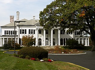
The Prospect Hill Historic District is an irregularly-shaped 185-acre (75 ha) historic district in New Haven, Connecticut. The district encompasses most of the residential portion of the Prospect Hill neighborhood.

The Whitney Avenue Historic District is a historic district in the East Rock neighborhood of New Haven, Connecticut. It is a 203-acre (82 ha) district which included 1,084 contributing buildings when it was listed on the National Register of Historic Places in 1989.

The Dwight Street Historic District is an irregularly shaped 135-acre (55 ha) historic district in New Haven, Connecticut. The district is located immediately west of the center of Downtown New Haven and is generally bounded by Elm Street on the north, Park Street on the east, North Frontage Road on the south, and Sherman Avenue on the west. It contains one of the city's highest concentrations of well-preserved 19th and early 20th-century residential architecture, much of which was developed for the working classes in the city's factories. It was listed on the National Register of Historic Places in 1983. The historic district includes most of the Dwight neighborhood and several blocks of the northeast corner of the West River neighborhood.

The Hillside Historic District in Waterbury, Connecticut is a 106-acre (43 ha) historic district that was listed on the National Register of Historic Places (NRHP) in 1987. It encompasses a residential area north of the city's central business district, and is bounded on the south by West Main Street, the west by Willow Avenue and Cliff and Frederick Streets, on the north by Buckingham Street and Woodland Terrace, and on the east by Cook Street. Developed principally over an 80-year period between 1840 and 1920, it includes a cross-section of architectural styles of the 19th and early 20th centuries. The area was a desirable neighborhood of the city for much of this time, and was home to a number of the city's elite. In 1987, it included 395 buildings deemed to contribute to the historic character of the area, and one other contributing structure. It includes the Wilby High School and the Benedict-Miller House, which are both separately listed. 32 Hillside Road, a several acre property that includes the Benedict Miller House, was the original site of The University of Connecticut's Waterbury Branch until 2003.

The Orange Street Historic District encompasses a large residential in the East Rock section of New Haven, Connecticut. Roughly bounded by Orange, Cottage, Eagle, State, and Audubon Streets, this area saw growth between about 1830 and 1900, and includes a broad diversity of well-preserved 19th-century residential structures. It was listed on the U.S. National Register of Historic Places in 1985. At that time, it included 546 buildings deemed to contribute to the historic character of the area.

The Prospect Avenue Historic District encompasses a predominantly residential area in western Hartford and eastern West Hartford, Connecticut. The 300-acre (120 ha) historic district extends along Prospect Avenue from Albany Avenue to Fern Street, including most of the area between those streets and the Park River to the east, and Sycamore Street and Sycamore Lane to the west. The district includes 240 contributing buildings and 48 non-contributing buildings, most of them residences built between 1880 and 1930. The district was listed on the National Register of Historic Places in 1985.
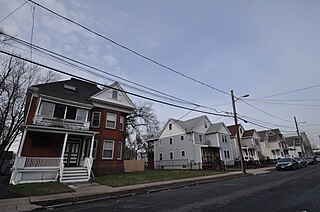
The Allen Place–Lincoln Street Historic District encompasses a small neighborhood of late 19th-century housing built for white-collar service workers in southern Hartford, Connecticut. It is roughly bounded by Madison, Washington, and Vernon Streets, and Zion Hill Cemetery, and has well-preserved examples of vernacular Queen Anne and Colonial Revival architecture. It was listed on the National Register of Historic Places in 2003.

The Federal Hill Historic District encompasses a predominantly residential area of Bristol, Connecticut, known for its high-quality 19th and early 20th-century residential architecture. Centered around the Federal Hill Green, it developed as a fashionable residential area, and features a large number of fine Italianate and Victorian houses. It was listed on the National Register of Historic Places in 1986.

The Jefferson-Seymour District is a historic district encompassing a residential area on the south side of Hartford, Connecticut. Covering portions of Cedar, Wadsworth, Seymour and Jefferson Streets, it contains a well-preserved collection of late 19th and early 20th-century middle-class residential architecture, primarily executed in brick. It was listed on the National Register of Historic Places in 1979.

The Garvan-Carroll Historic District encompasses a primarily residential area near the center of East Hartford, Connecticut. Located just southwest of its Main Street downtown on South Prospect and Garvan Streets, and Carroll and Tower Roads, this area retains a high concentration of residential architecture built mainly between 1890 and the 1920s. It was listed on the National Register of Historic Places in 1991.

The Laurel and Marshall Streets District is a historic district encompassing a late-19th and early-20th century residential area in the Asylum Hill neighborhood of Hartford, Connecticut. Extending along Laurel and Marshall Streets between Niles and Case Streets, its housing stock represents a significant concentration of middle-class Queen Anne architecture in the city. It was listed on the National Register of Historic Places in 1979.
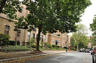
The Little Hollywood Historic District encompasses a concentrated collection of apartment buildings built mainly between the world wars in the Asylum Hill neighborhood of Hartford, Connecticut. Located on Farmington Avenue and Owen, Frederick, and Denison Streets, they were built primarily to attract single tenants seeking small apartments, a trend that developed after World War I and ended after World War II. The district was listed on the National Register of Historic Places in 1982.
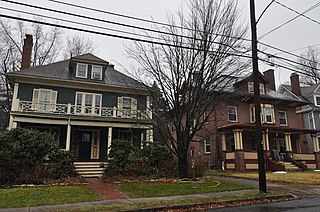
The Oxford-Whitney Streets District is a historic district encompassing an early-20th century residential area in the West End neighborhood of Hartford, Connecticut. It extends along the east side of Oxford Street between Elizabeth and Cone Streets, on the west side of Whitney between Fern and Elizabeth, and includes the north side of Fern Street between Whitney and Oxford. Most of the housing, a combination of single and multi-family residences, was built between 1906 and 1919, a period later than the surrounding areas, and is predominantly Colonial Revival in character. It was listed on the National Register of Historic Places in 2010.
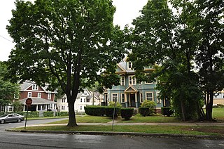
The Sisson-South Whitney Historic District encompasses a neighborhood in the West End area of Hartford, Connecticut, that was built out between 1890 and 1930 as a streetcar suburb. It is roughly bounded by Farmington Avenue, South Whitney Street, West Boulevard, and Sisson Avenue, and includes a diversity of residential and commercial architecture, reflective of its initial development and subsequent growth. The district was listed on the National Register of Historic Places in 2013.

The Upper Albany Historic District encompasses a predominantly residential area of the North End of Hartford, Connecticut. It extends along Albany Avenue between Garden and Woodland Streets, including side streets to the south, and extends northward to include the southern portion of Keney Park. This area was developed in the first two decades of the 20th century, and has a fine array of period middle-class housing in the Queen Anne and Colonial Revival styles. It was listed on the National Register of Historic Places in 1986.
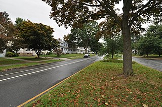
The West Boulevard Historic District encompasses a historic residential development on West Boulevard and Rodney Street in the West End of Hartford, Connecticut. The area was developed beginning in 1909, and most of its homes were built by a single construction firm, creating a neighborhood appearance unified by style, scale, and setting, using the principles of the then-fashionable City Beautiful movement. The district was listed on the National Register of Historic Places in 2007.

