
The Flanders Historic District is a historic district that encompasses a small cluster of late-18th to early-19th century residential structures north of the center of Kent, Connecticut, which was the original heart of the community when it was first settled. It is centered at the junction of United States Route 7 with Cobble Road and Studio Hill Road. The area was supplanted by the current town center in the 1840s. The district was listed on the National Register of Historic Places in 1979.

Phillipston Center Historic District encompasses the historic village center of Phillipston, Massachusetts. The town was first settled in 1751 on land grants made in the 1730s, and was incorporated as a separate town in the 1770s. The surviving village center is not far from the location of the first settlement, which eventually came to include a tavern. After incorporation the center developed around what is now the junction of the Baldwinville, Petersham, and Templeton Roads, although this took time, possibly because of difficulties associated with the American Revolutionary War. As a result, the district has relatively few properties that date to the 18th century. All of these are modest vernacular residential structures. The town grew only modestly until 1830, after which time its population declined, not reaching the same level until 1980, 150 years later. As a result of the lack of growth, most of the properties in the district are Federal and Greek Revival in character. Many of the institutional buildings in the center date to the late 19th and early 20th centuries. The district was added to the National Register of Historic Places in 1999.

The Ludlow Center Historic District encompasses the historic village center of Ludlow, Massachusetts. Centered on the junction of Center, Church and Booth Streets, it is the site selected as the town center when Ludlow was established in 1774. Its notable structures include the Congregational Church, the old town hall, and a number of farmhouses that date to the first half of the 19th century. The area has remained a center of civic life in the town, even though its economic center moved later in the 19th century to Ludlow Village. The district was listed on the National Register of Historic Places in 1988.

The Waterville Village Historic District encompasses most of the history 19th and early 20th-century village center of Waterville, Vermont. The village grew from beginnings late in the 18th century to serve as a modest civic, commercial, and residential hub for the rural community. It was added to the National Register of Historic Places in 2007.
The Windham Village Historic District is one of two historic districts in Windham, Vermont, encompassing the dispersed rural village near the town's geographic center. The area was principally developed in the early decades of the 19th century, and has had only modest alterations since then. It was listed on the National Register of Historic Places in 1984.

The New Gloucester Historic District encompasses the rural village center of New Gloucester, Maine. The village is one of the few in Maine's inland areas to be settled in the second half of the 18th century, and has a significant concentration of 18th-century residences. It was added to the National Register of Historic Places in 1974.

The Chesterfield Center Historic District is a historic district that encompasses the traditional village center of the town of Chesterfield, Massachusetts. The village is reflective of the town's 18th and 19th-century development as an agrarian hill community, with architectural styles before about 1850 predominating. The district was listed on the National Register of Historic Places in 2000.

The Lord's Hill Historic District encompasses a historic village center in Effingham, New Hampshire. Located along New Hampshire Route 153 on a hill in northern Effingham, it is a well-preserved late 18th and early 19th-century rural village. It is named for Isaac Lord, a leading figure in its development in the early 19th century. The district was listed on the National Register of Historic Places in 1985.

The Lower Corner Historic District encompasses a small village center in the town of Sandwich, New Hampshire. Lower Corner is a rural village that is strung along New Hampshire Route 109 on either side of its junction with School House Road, about one mile from the main village of Center Sandwich. The village was developed relatively early in Sandwich's history, although its oldest buildings now date to the early 19th century. There are 25 contributing structures, mostly residences. There are two buildings built as stores, including one of brick; all the other buildings are wood frame. The district was listed on the National Register of Historic Places in 1986.

The Wakefield Village Historic District encompasses the historic village center of Wakefield, New Hampshire. It is centered at the junction of New Hampshire Route 153 and Mountain Laurel Road, which was historically the major north-south route in Carroll County. The district consists mainly of residential properties dating from the 18th to early 20th centuries, and also includes the 1836 town hall, public library¸ Grange Hall, and a one-room schoolhouse that now houses the local historical society. The district was listed on the National Register of Historic Places in 1984.

The Limington Historic District encompasses the historic village center of the rural community of Limington, Maine. Centered at the junction of Maine State Routes 11 and 117, the district includes 24 buildings erected between the late 18th and mid-19th centuries. The district was listed on the National Register of Historic Places in 1999.

The Salmon Falls (East) Historic District encompasses a node of rural development in western Buxton, Maine. It includes thirteen historic properties, mainly Greek Revival in character, extending north along Maine State Route 117, north of its junction with Simpson Road, and two on the latter street, that were all built between about 1800 and 1850. The district was listed on the National Register of Historic Places in 1987.

Corinth Village, also known as the Skinner Settlement Historic District and West Corinth, is an early 19th-century rural crossroads village in the small town of Corinth, Maine. Centered at the junction of Ledge Hill and West Corinth Roads, the village includes a number of buildings constructed before 1850, one of which may have been the first frame structure built in the area. The village was listed as a historic district on the National Register of Historic Places in 1973.

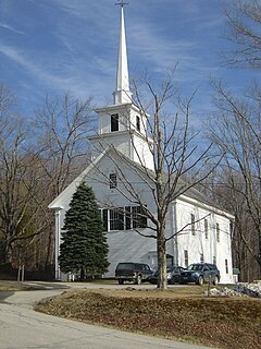
The Rockingham Village Historic District encompasses the traditional village center of the town of Rockingham, Vermont. Settled in the 18th century, the district, located mainly on Meeting House Road off Vermont Route 103, includes a variety of 18th and 19th-century houses, and has been little altered since a fire in 1908. It notably includes the 18th-century National Historic Landmark Rockingham Meeting House. The district was listed on the National Register of Historic Places in 2008.
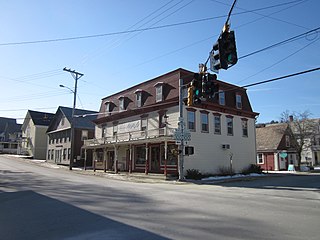
The Wilmington Village Historic District encompasses a significant portion of the village center of Wilmington, Vermont. The village grew as a crossroads industrial center through the mid-19th century, and experienced relatively little growth afterward. The district was listed on the National Register of Historic Places in 1980.

The Days Ferry Historic District encompasses a rural village that grew around a ferry crossing on the Kennebec River in what is now Woolwich, Maine. The village and ferry were on the main stage route between Bath and Wiscasset until the 1870s, and retains a concentration of well-preserved 18th and early 19th-century houses. The district was listed on the National Register of Historic Places in 1975.
The Christian Street Rural Historic District encompasses the surviving elements of an early settlement village in the town of Hartford, Vermont. Centered on the junction of Christian Street and Jericho Street in northeastern Hartford, the area includes a modest number of 18th and 19th-century houses, as well as two farms that have been in the same families since the 18th century. The district was listed on the National Register of Historic Places in 2003.

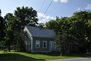
The West Newbury Village Historic District encompasses the modest rural country village of West Newbury, Vermont. It is located at the junction of Tucker Mountain, Snake, and Tyler Farm Roads, and is relatively little altered since its 19th-century development. It was listed on the National Register of Historic Places in 1983.
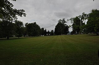
The Waitsfield Common Historic District encompasses the original town center settlement of Waitsfield, Vermont, at the junction of Joslin Hill, Common, East, and North Roads. Located about 1 mile (1.6 km) from the town's present main village and center, it was laid out in 1793, and includes the triangular town common, a cemetery, and a number of houses built mainly between 1793 and 1841. The district was listed on the National Register of Historic Places in 2001.

The Peacham Corner Historic District encompasses much of the historic village center of Peacham, Vermont. The village's period of greatest growth and importance between the town's founding as a hill town in the late 18th century, and 1860, when significant development effectively ended. As a result, the village lacks Victorian features often found in other rural communities. The district was listed on the National Register of Historic Places in 2003.


