West Newton | |
---|---|
Coordinates: 44°15′54″N91°54′03″W / 44.26500°N 91.90083°W Coordinates: 44°15′54″N91°54′03″W / 44.26500°N 91.90083°W | |
Country | United States |
State | Minnesota |
County | Wabasha |
Elevation | 666 ft (203 m) |
Time zone | UTC-6 (Central (CST)) |
• Summer (DST) | UTC-5 (CDT) |
Area code(s) | 651 |
GNIS feature ID | 655004 [1] |
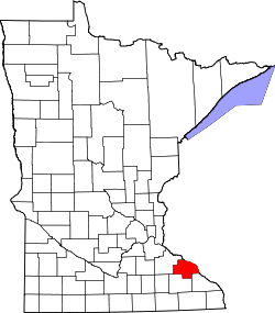
West Newton is an unincorporated community in Wabasha County, Minnesota, United States. [1]
Wabasha County is a county in the U.S. state of Minnesota. As of the 2010 United States Census, the population was 21,676. Its county seat is Wabasha.
Minnesota is a state in the Upper Midwest, Great Lakes, and northern regions of the United States. Minnesota was admitted as the 32nd U.S. state on May 11, 1858, created from the eastern half of the Minnesota Territory. The state has a large number of lakes, and is known by the slogan the "Land of 10,000 Lakes". Its official motto is L'Étoile du Nord.
The United States of America (USA), commonly known as the United States or America, is a country comprising 50 states, a federal district, five major self-governing territories, and various possessions. At 3.8 million square miles, the United States is the world's third or fourth largest country by total area and is slightly smaller than the entire continent of Europe's 3.9 million square miles. With a population of over 327 million people, the U.S. is the third most populous country. The capital is Washington, D.C., and the most populous city is New York City. Forty-eight states and the capital's federal district are contiguous in North America between Canada and Mexico. The State of Alaska is in the northwest corner of North America, bordered by Canada to the east and across the Bering Strait from Russia to the west. The State of Hawaii is an archipelago in the mid-Pacific Ocean. The U.S. territories are scattered about the Pacific Ocean and the Caribbean Sea, stretching across nine official time zones. The extremely diverse geography, climate, and wildlife of the United States make it one of the world's 17 megadiverse countries.
This article about a location in Wabasha County, Minnesota is a stub. You can help Wikipedia by expanding it. |
Winona County is a county in the U.S. state of Minnesota. As of the 2018 census, its estimated population was 50,825. Its county seat is Winona.
Olmsted County is a county in the U.S. state of Minnesota. As of the 2010 census, the population was 144,248, and has an estimated population of 156,277 as of 2018. Its county seat and largest city is Rochester.
Wabasha is a city in Wabasha County, Minnesota, United States. The population was 2,521 at the 2010 census. Located on the Mississippi River near its confluence with the Chippewa River, it is the county seat.
The Zumbro River is a tributary of the Mississippi River in the Driftless Area of southeastern Minnesota in the United States. It is 64.6 miles (104.0 km) long from the confluence of its principal tributaries and drains a watershed of 1,428 square miles (3,700 km2). The river's name in English is a change from its French name Rivière des Embarras due to its mouth located near Pine Island in the Mississippi River; the Dakota name for this river is Wapka Wazi Oju, having reference to the grove of great white pines at Pine Island.
Weaver is an unincorporated community in Minneiska Township, Wabasha County, Minnesota, United States. The Whitewater River and the Mississippi River meet at Weaver.
Addison Gardner Foster was a United States Senator from Washington.
West Albany is an unincorporated community in West Albany Township, Wabasha County, Minnesota, United States.
South Troy is an unincorporated community in Zumbro Township, Wabasha County, Minnesota, United States. It is located on U.S. Highway 63 about 13 miles north of Rochester. Nearby places include Hammond, Zumbro Falls, Mazeppa, Potsdam, and Oronoco. Wabasha County Roads 7 and 11 are nearby.
West Newton is the name of various locations:
This is a list of the National Register of Historic Places listings in Wabasha County, Minnesota. It is intended to be a complete list of the properties and districts on the National Register of Historic Places in Wabasha County, Minnesota, United States. The locations of National Register properties and districts for which the latitude and longitude coordinates are included below, may be seen in an online map.
Maple Springs is an unincorporated community in Pepin Township, Wabasha County, Minnesota, United States, along the Mississippi River and Lake Pepin. The Mississippi River and King Creek meet at Maple Springs.
Reads Landing is an unincorporated community in Pepin Township, Wabasha County, Minnesota, United States, along the Mississippi River.
Camp Lacupolis is an unincorporated community in Pepin Township, Wabasha County, Minnesota, United States, along the Mississippi River and Lake Pepin.
Oak Center is an unincorporated community in Gillford Township, Wabasha County, Minnesota, United States.
Theilman is an unincorporated community in Wabasha County, Minnesota, United States.
Jarrett is an unincorporated community in Wabasha County, Minnesota, United States.
Dumfries is an unincorporated community in Glasgow Township, Wabasha County, Minnesota, United States.
Conception is an unincorporated community in Highland Township, Wabasha County, Minnesota, United States.
Bear Valley is an unincorporated community in Chester Township, Wabasha County, Minnesota, United States.