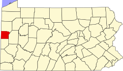
West Pittsburg, Pennsylvania | |
---|---|
Coordinates: 40°55′58″N80°21′48″W / 40.93278°N 80.36333°W | |
Country | United States |
State | Pennsylvania |
County | Lawrence |
Township | Taylor |
Area | |
• Total | 0.69 sq mi (1.78 km2) |
• Land | 0.69 sq mi (1.78 km2) |
• Water | 0.0 sq mi (0.0 km2) |
Elevation | 842 ft (257 m) |
Population | |
• Total | 808 |
• Density | 1,178/sq mi (454.8/km2) |
Time zone | UTC-5 (EST) |
• Summer (DST) | UTC-4 (EDT) |
ZIP code | 16160 [4] |
Area code | 724 |
GNIS feature ID | 2633816 [2] |
West Pittsburg is an unincorporated community and census-designated place (CDP) in southern Taylor Township, Lawrence County, Pennsylvania, United States. As of the 2010 census it had a population of 808. [3]
It is located in the Beaver River valley 5 miles (8 km) south of New Castle. Its main street is the north-south Pennsylvania Route 168, which crosses the river at the southern end of the community. [5]
The community is 46 miles (74 km) north-northwest of the city of Pittsburgh.
For a small community, West Pittsburg had one of the largest railroad stations built in the north Pittsburgh area. At one time, the Pittsburgh and Lake Erie Railroad thought that the community would become a major railroad hub and constructed a large railroad station that would serve passengers on "The Little Giant".
Other railroads that would have benefited were the Baltimore and Ohio Railroad and the Western Allegheny Railroad; however, the hub never materialized. Over time, the three railroads went out of business, but CSX Transportation and the Buffalo and Pittsburgh Railroad continue to use the yard near the West Pittsburg Station to transport freight to cities like Pittsburgh, Butler, Cleveland, New Castle, and Youngstown.
Big Beaver is a borough in northern Beaver County, Pennsylvania, United States. The population was 1,852 at the 2020 census. It is a part of the Pittsburgh metropolitan area. The area was originally incorporated as Big Beaver Township in 1802, and was reincorporated as a borough in 1958.
Saxton is a borough in Bedford County, Pennsylvania, United States. The population was 726 at the 2020 census.
Rothsville is an unincorporated community and census-designated place (CDP) in Warwick Township, Lancaster County, Pennsylvania, United States. The population was 3,044 at the 2010 census. Lititz is the town for residents' mailing addresses.
New Castle is a city in and the county seat of Lawrence County, Pennsylvania, United States. Located along the Shenango River at the mouth of Neshannock Creek, it is 43 miles (69 km) northwest of Pittsburgh near the Pennsylvania–Ohio border, approximately 17 miles (27 km) southeast of Youngstown, Ohio. As of the 2020 census, the city had a population of 21,926. The commercial center of a fertile agricultural region, New Castle is included in the northwestern part of the Pittsburgh metropolitan area.
New Castle Northwest is an unincorporated area and census-designated place (CDP) in Lawrence County, Pennsylvania, United States. The population was 1,413 at the 2010 census.
Oakland is an unincorporated area and census-designated place (CDP) in Lawrence County, Pennsylvania, United States. The population was 1,569 at the 2010 census.
Oakwood is an unincorporated area and census-designated place (CDP) in Lawrence County, Pennsylvania, United States. The population was 2,270 at the 2010 census.
South Pittsburg is a city in Marion County, Tennessee, United States. It is part of the Chattanooga, TN–GA Metropolitan Statistical Area. The population was 3,106 at the 2020 census. South Pittsburg is home to the National Cornbread Festival.
Leola is a census-designated place (CDP) in Lancaster County, Pennsylvania, United States. It includes the unincorporated communities of Leola, Leacock, and Bareville, and prior to 2010 was known as the Leacock-Leola-Bareville census-designated place. Originally named "Mechanicsburg", its present name is a portmanteau of "Leacock" and the "Glenola" train station that once served the town. As of the 2010 census, the population of the CDP was 7,214.
Watersmeet is an unincorporated community and census-designated place (CDP) in Watersmeet Township, Michigan. As of the 2010 census, the CDP had a population of 428, out of a total population in the township of 1,417. The community was platted in 1884, designated as a station of the Milwaukee Lake Shore and Western Railroad.
Ronks is a small unincorporated farming community and census-designated place (CDP) in East Lampeter Township, Lancaster County, Pennsylvania, United States, just west of Paradise. As of the 2010 census the population was 362.
Stevens is an unincorporated community and census-designated place (CDP) in Lancaster County, Pennsylvania, United States. As of the 2010 census, it had a population of 612. The Stevens post office has ZIP code 17578.
Negley is an unincorporated community and census-designated place in Middleton Township, Columbiana County, Ohio, United States. The population was 274 at the 2020 census. Historically a mining community, it lies at the confluence of Bull Creek and the North Fork of the Little Beaver Creek at the state border with Pennsylvania. State Routes 154 and 170 as well as the Youngstown and Southeastern Railroad pass through the community.
Wakefield is an unincorporated community and census-designated place (CDP) within Fulton Township, Lancaster County, Pennsylvania, United States. As of the 2010 census, the population was 609. It is the largest community within the "Peach Bottom" ZIP code, with the area post office on Pennsylvania Route 272, just north of town.
Refton is an unincorporated community and census-designated place (CDP) in Strasburg Township, Lancaster County, Pennsylvania, United States, with a ZIP code of 17560. The community is located along U.S. Route 222. As of the 2010 census, the population was 298.
Lawrence County is a county in the Commonwealth of Pennsylvania. As of the 2020 census, the population was 86,070. The county seat and largest city is New Castle.
Chewton is an unincorporated community and census-designated place (CDP) in Lawrence County, Pennsylvania, United States. The population was 488 at the 2010 census.
Frizzleburg is an unincorporated community and census-designated place (CDP) in Lawrence County, Pennsylvania, United States. The population was 602 at the 2010 census.
New Bedford is an unincorporated community and census-designated place (CDP) in Lawrence County, Pennsylvania, United States. The population was 925 at the 2010 census.
Clay is an unincorporated community and census-designated place (CDP) in Clay Township, Lancaster County, Pennsylvania, United States. It is located along U.S. Route 322 between Brickerville and Ephrata. As of the 2010 census, the population was 1,559.