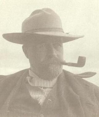
John Calvin Stevens was an American architect who worked in the Shingle Style, in which he was a major innovator, and the Colonial Revival style. He designed more than 1,000 buildings in the state of Maine.

Evergreen Cemetery is a garden-style cemetery on Stevens Avenue in the Deering neighborhood of Portland, Maine. With 239 acres (97 ha) of land, it is the largest cemetery in the state. Established in 1855, in what was then Westbrook, the cemetery is home to one of the state's most prominent collections of funerary art. The 140-acre (57 ha) historical portion of the cemetery was listed on the National Register of Historic Places in 1992.

The History of Portland, Maine, begins when Native Americans originally called the Portland peninsula Məkíhkanək meaning "At the fish hook" in Penobscot and Machigonne in Algonquian. The peninsula and surrounding areas was home to members of the Algonquian-speaking Aucocisco branch of the Eastern Abenaki tribe who were forcibly relocated to current day Canada during European settlement.
William Lawrence Bottomley, was an American architect in twentieth-century New York City; Middleburg, Virginia; and Richmond, Virginia. He was known for his Colonial Revival designs of residential buildings in the United States and many of his commissions are situated in highly aspirational locations, including Monument Avenue in Richmond, Virginia.
The West End is a downtown neighborhood in Portland, Maine. It is located on the western side of Portland's peninsula primarily on Bramhall Hill and is noted for its architecture and history. The neighborhood is home to many late 19th- and early 20th-century homes and, in 2010, it was called "one of the best preserved Victorian neighborhoods in the country". The Western Promenade, a park laid out in 1836, overlooks the forests and small settlements of Southwestern Maine, along with the distant White Mountains. Other historic structures include 68 High Street, The Gothic House, Brown House, Butler House, Ingraham House, Morrill Mansion and the Minott House.

The Williston-West Church and Parish House are an historic church and house at 32 Thomas Street in the West End neighborhood of Portland, Maine, United States. The church was built in 1897, and is a significant Gothic work by Francis H. Fassett. The parish house, built in 1905, was designed by John Calvin Stevens and John Howard Stevens. The church is historically notable as the founding site of Christian Endeavor International, consider a major forerunner of modern youth ministries. The property was listed on the National Register of Historic Places in 1980. The church congregation merged with another in 2011, and the property was sold for rehabilitation and redevelopment. It now houses professional offices.

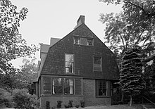
The John Calvin Stevens House is an historic house at 52 Bowdoin Street in the West End neighborhood of Portland, Maine. Built in 1884, it was the home of architect John Calvin Stevens, and was one of Portland's earliest examples of Shingle style architecture. The house was prominently used by Stevens in promotion of the style, and was listed on the National Register of Historic Places in 1973.
Portland, Maine, is home to many neighborhoods.
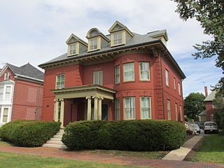
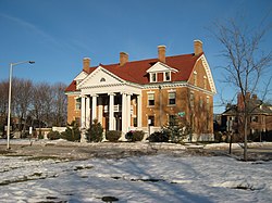
The Adam P. Leighton House is an historic house at 261 Western Promenade in Portland, Maine. Built in 1903, it is a fine local example of Colonial Revival architecture, and is further prominent as home to Adam P. Leighton, who was "considered the father of the American postcard industry", and served as the Mayor of Portland from 1908 to 1909. The house was listed on the National Register of Historic Places in 1982.

The Deering Street Historic District is a historic district in the Downtown and Parkside neighborhoods of Portland, Maine. Encompassing all of Deering Street and much of State Street, as well as adjacent portions of Congress and Mellen Streets, it is a cohesive collection of high quality architect-designed buildings from the second half of the 19th century, that were originally predominantly residential in nature. The district was added to the National Register of Historic Places in 1983.
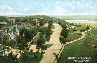
The Western Promenade is a historic promenade, an 18.1-acre (7.3 ha) public park and recreation area in the West End neighborhood of Portland, Maine. Developed between 1836 and the early 20th century, it is one Portland's oldest preserved spaces, with landscaping by the Olmsted Brothers, who included it in their master plan for the city's parks. The promenade was listed on the National Register of Historic Places in 1989.

The Spring Street Historic District encompasses surviving elements of the 19th-century commercial and surviving residential areas of Portland, Maine. Encompassing a portion of the city's Arts District and an eastern portion of its West End, the district has a significant concentration of residential and commercial buildings that survived the city's devastating 1866 fire. The district was listed on the National Register of Historic Places in 1970.

The Westbrook College Historic District is a historic district in the Deering neighborhood of Portland, Maine. It is centered on the campus of the former Westbrook College, founded in 1831 as the nation's first coeducational boarding school. The college merged with the University of New England in 1996. The district, which includes six buildings constructed between 1833 and 1952, was added to the National Register of Historic Places in 1977.

Frederick Augustus Tompson was an American architect from Portland, Maine.

The Bath Historic District encompasses the historic 19th-century business district of Bath, Maine, along with an adjacent period neighborhood. The city has a long history as one of the nation's preeminent shipbuilding centers. The district was listed on the National Register of Historic Places in 1973.

Main Street is a historic street in Yarmouth, Maine, United States. It is part of the 18-mile-long (29 km) State Route 115 (SR 115), the eastern terminus of which is in Yarmouth at the intersection of Marina Road and Lafayette Street (SR 88), at Yarmouth Harbor in the Lower Falls area. Its western end is a merging with Walnut Hill Road in North Yarmouth, at which point SR 115 continues west.
Charles Albert Alexander was an American architect active in the second half of the 19th century. He designed notable buildings in Boston, Portland (Maine), New York City and Chicago.

John P. Thomas was an American architect in practice in Portland, Maine.
George Burnham was an American architect from Portland, Maine. He was active in the second half of the 20th century and first half of the 21st century.

Bramhall was a mansion in the Bramhall neighborhood of Portland, Maine, United States. Completed in 1858, it was owned by John Bundy Brown, an industrialist. The mansion, which was designed by New York City architect Charles A. Alexander, stood behind today's 147–163 Western Promenade, near which he also built homes for his children. After Brown's death, the mansion, which was the largest residence in Portland, was demolished. The 10 acres (4.0 ha) of land bounded by Bowdoin Street, Pine Street, Vaughan Street and Western Promenade was sold parcel by parcel, and the present neighborhood was built. The area is now part of the Western Promenade Historic District.