The Fan is a district of Richmond, Virginia, so named because of the "fan" shape of the array of streets that extend west from Belvidere Street, on the eastern edge of Monroe Park, westward to Arthur Ashe Boulevard. However, the streets rapidly resemble a grid after they go through what is now Virginia Commonwealth University. The Fan is one of the easterly points of the city's West End section, and is bordered to the north by Broad Street and to the south by VA 195, although the Fan District Association considers the southern border to be the properties abutting the south side of Main Street. The western side is sometimes called the Upper Fan and the eastern side the Lower Fan, though confusingly the Uptown district is located near VCU in the Lower Fan. Many cafes and locally owned restaurants are located here, as well as historic Monument Avenue, a boulevard formerly featuring statuary of the Civil War's Confederate president and generals. The only current statue is a more modern one of tennis icon Arthur Ashe. Development of the Fan district was strongly influenced by the City Beautiful movement of the late 19th century.

Kenwood, one of Chicago's 77 community areas, is on the shore of Lake Michigan on the South Side of the city. Its boundaries are 43rd Street, 51st Street, Cottage Grove Avenue, and the lake. Kenwood was originally part of Hyde Park Township, which was annexed to the city of Chicago in 1889. Kenwood was once one of Chicago's most affluent neighborhoods, and it still has some of the largest single-family homes in the city. It contains two Chicago Landmark districts, Kenwood and North Kenwood. A large part of the southern half of the community area is in the Hyde Park-Kenwood Historic District. In recent years, Kenwood has received national attention as the home of former U.S. President Barack Obama.

U.S. Route 66 was a United States Numbered Highway in Illinois that connected St. Louis, Missouri, and Chicago, Illinois. The historic Route 66, the Mother Road or Main Street of America, took long distance automobile travelers from Chicago to Southern California. The highway had previously been Illinois Route 4 and the road has now been largely replaced with Interstate 55 (I-55). Parts of the road still carry traffic and six separate portions of the roadbed have been listed on the National Register of Historic Places.
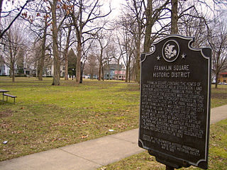
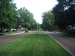
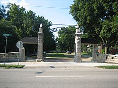
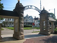
Franklin Square, or Franklin Park is located in Bloomington, Illinois, McLean County. Listed on the National Register of Historic Places, Franklin Square contains the homes of former Vice President Adlai Stevenson I and former Governor Joseph W. Fifer. In 1979 the square was designated as a local historic district. Located northeast of downtown Bloomington, the square encompasses the 300 and 400 blocks of E. Chestnut and E. Walnut streets and the 900 block of N. Prairie and N. McLean streets.
Golden Hill is an affluent and historic neighborhood overlooking the White River on the west side of Indianapolis's Center Township, in Marion County, Indiana. The district is bounded on the east by Clifton Street, which is west of Martin Luther King Jr. Boulevard ; on the west by the White River and the Central Canal; on the south by Thirty-sixth Street; and on the north by Woodstock Country Club, immediately south of Thirty-eighth Street. Golden Hill is noted for its collection of homes designed by several of the city's prominent architects. The estate homes reflect several styles of period revival architecture. The district is known as for its community planning and remains an exclusive enclave for the city's prominent families. Golden Hill was added to the National Register of Historic Places in 1991.

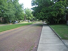
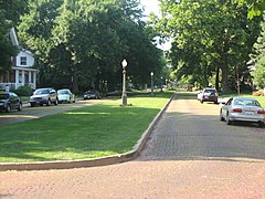
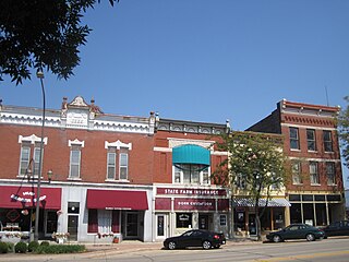
The East Grove Street District is a residential historic district located on the 400 through 700 blocks of East Grove Street in Bloomington, Illinois. The district includes 43 houses and apartment buildings, 25 of which are considered contributing buildings. The houses in the district were built between 1855 and 1915 for many of Bloomington's upper middle class residents. Due to a building boom between 1880 and 1900, the then-popular Queen Anne style is the most prevalent in the district. Other popular architectural styles in the district include Greek Revival homes from the 1850s, Italianate homes built between 1860 and 1880, and Arts and Crafts homes built in the 1900s.

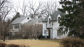
The Ruben M. Benjamin House is a house in Bloomington, Illinois. It is a two-story rectangular building, styled in the Classical Revival architectural motif. It was built in 1856 John L. Routt, who would become the first governor of Colorado. Ruben M. Benjamin, an attorney known for litigation relating to railroad regulation, lived in the home for more than 60 years. The United States National Register of Historic Places added the Ruben M. Benjamin House in August 1978.

The Upper Eastside is a neighborhood in Miami, Florida. It is north of Edgewater, east of Little Haiti, south of the village of Miami Shores, and sits on Biscayne Bay. In geographical order from south to north and east to west, it contains the subdivisions of Magnolia Park, Bay Point, Morningside, Bayside, Belle Meade, Shorecrest, and Palm Grove. The MiMo District along Biscayne Boulevard in the area is host to many art galleries, shops and restaurants.

The Yale Avenue Historic District is a residential historic district near the center of Wakefield, Massachusetts. It encompasses eight residential properties, all but one of which were developed in the 1860s and 1870s, after the arrival of the railroad in town. These properties were built primarily for Boston businessmen, and mark the start of Wakefield's transition to a suburb.

The Nobility Hill Historic District is a residential historic district roughly bounded by Chestnut and Maple Streets and Cedar Avenue in Stoneham, Massachusetts. The district includes a number of high quality houses representing a cross section of fashionable housing built between 1860 and 1920. It was added to the National Register of Historic Places in 1990.

The Vanderbilt Lane Historic District is a small area along the street of the same name, just east of US 9 in Hyde Park, New York, United States. It was used for the farm functions of the nearby estate of Walter Langdon and, later, Frederick Vanderbilt. Most of its buildings date to the turn of the 19th century, with one remaining from the 1830s.

There are nine historic districts in Meridian, Mississippi. Each of these districts is listed on the National Register of Historic Places. One district, Meridian Downtown Historic District, is a combination of two older districts, Meridian Urban Center Historic District and Union Station Historic District. Many architectural styles are present in the districts, most from the late 19th century and early 20th century, including Queen Anne, Colonial Revival, Italianate, Art Deco, Late Victorian, and Bungalow.

The Steele Dunning Historic District is a neighborhood and historic district in Bloomington, Indiana, United States. Composed of small, single- or double-family houses, the district includes houses built from the late nineteenth century through the middle of the twentieth century.

The Bloomington freight station is a historic train station in downtown Bloomington, Indiana, United States. Constructed in the early twentieth century, it has endured closure and a series of modifications to survive to the present day, and it has been declared a historic site. Used only occasionally for many years, it is one of the most important buildings in a large historic district on the city's west side.
The Belvidere South State Street Historic District is a historic district on the north side of the Kishwaukee River in Belvidere, Illinois. It is primarily composed of commercial building representative of architectural trends from 1852 to 1962, the period following the connection of the city to the Galena and Chicago Union Railroad.

The Lyme Common Historic District encompasses the original historic center of Lyme, New Hampshire. Established in 1781, it includes sixty historic buildings surrounding the town common and along surrounding roads, and is a well-preserved example of a 19th-century village center. The district was listed on the National Register of Historic Places in 1988.

The Whitney Park Historic District is a residential historic district on the west side of Bangor, Maine. The district contains 42 residential properties built between 1850 and 1910, a major period of the city's growth, and is anchored on its south by Whitney Park, a small triangular park at Hammond and Cedar Streets. The district was listed on the National Register of Historic Places in 1988, and is protected by the city's local historic district ordinance.

The Main Street–College Street Historic District encompasses a historically fashionable residential area of Burlington, Vermont. Principally located along Main and College Streets between South Winooski and South Williams Streets, the area was one of the city's most exclusive residential areas from the early 19th century to the early 20th century, and includes a diversity of high quality architecture from that period. It was listed on the National Register of Historic Places in 1988.
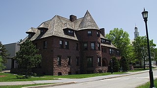
Redstone is a historic former estate on South Prospect Street in Burlington, Vermont. It was developed in 1889, and includes some of Burlington's finest examples of Richardsonian Romanesque, Shingle, and Colonial Revival architecture. Its surviving elements are Redstone Green and some of its surrounding buildings on the campus of the University of Vermont, which acquired the property in 1921, and are part of the university's Redstone Campus. It was listed on the National Register of Historic Places in 1991 as the Redstone Historic District.

The West End North Historic District encompasses a neighborhood of late 19th and early 20th century residential architecture in western Hartford, Connecticut and eastern West Hartford, Connecticut. Roughly bounded by Prospect, Elizabeth, and Lorraine Streets and Farmington Avenue, the area includes a large number of Colonial Revival and Queen Anne houses, as well as numerous buildings in other period styles, with only a small number of losses. It was listed on the National Register of Historic Places in 1985.