Whitestown, Wisconsin

Last updated

Whitestown, Wisconsin
Vernon County Wisconsin incorporated and unincorporated areas Whitestown highlighted.svg
Location in Vernon County and the state of Wisconsin.
Coordinates: 43°40′6″N90°36′32″W / 43.66833°N 90.60889°W / 43.66833; -90.60889
Country Flag of the United States.svg  United States
State Flag of Wisconsin.svg  Wisconsin
County Vernon
Area
  Total35.0 sq mi (90.7 km2)
  Land35.0 sq mi (90.7 km2)
  Water0.0 sq mi (0.0 km2)
Elevation
[1]
853 ft (260 m)
Population
 (2000)
  Total509
  Density14.5/sq mi (5.6/km2)
Time zone UTC-6 (Central (CST))
  Summer (DST) UTC-5 (CDT)
Area code 608
FIPS code 55-86900 [2]
GNIS feature ID1584431 [1]

Whitestown is a town in Vernon County, Wisconsin, United States. The population was 509 at the 2000 census. The unincorporated community of Rockton is located in the town.

Contents

Geography

According to the United States Census Bureau, the town has a total area of 35.0 square miles (90.7 km2), all of it land.

Demographics

At the 2000 census there were 509 people, 167 households, and 122 families in the town. The population density was 14.5 people per square mile (5.6/km2). There were 242 housing units at an average density of 6.9 per square mile (2.7/km2). The racial makeup of the town was 97.45% White, 0.20% Native American, 0.79% Asian, 0.59% from other races, and 0.98% from two or more races. Hispanic or Latino of any race were 0.59%. [2]

Of the 167 households 35.3% had children under the age of 18 living with them, 64.7% were married couples living together, 5.4% had a female householder with no husband present, and 26.9% were non-families. 22.2% of households were one person and 3.0% were one person aged 65 or older. The average household size was 3.04 and the average family size was 3.68.

The age distribution was 35.0% under the age of 18, 7.3% from 18 to 24, 25.5% from 25 to 44, 24.2% from 45 to 64, and 8.1% 65 or older. The median age was 34 years. For every 100 females, there were 105.2 males. For every 100 females age 18 and over, there were 116.3 males.

The median household income was $33,472 and the median family income was $40,750. Males had a median income of $30,278 versus $20,625 for females. The per capita income for the town was $13,289. About 7.1% of families and 11.2% of the population were below the poverty line, including 12.4% of those under age 18 and 14.7% of those age 65 or over.

Related Research Articles

<span class="mw-page-title-main">Fortville, Indiana</span> Town in Indiana, United States

Fortville is a town in Vernon Township, Hancock County, Indiana, United States. The population was 4,784 at the 2020 census.

<span class="mw-page-title-main">Cannelton, Indiana</span> City in Indiana, United States

Cannelton is a city in Troy Township, Perry County, in the U.S. state of Indiana, along the Ohio River. The population was 1,563 at the 2010 census. Cannelton, which was the smallest incorporated city in the state until 2010, was formerly the county seat of Perry County until the seat was relocated to Tell City.

<span class="mw-page-title-main">St. Agatha, Maine</span> Town in the state of Maine, United States

St. Agatha is a town in Aroostook County, Maine, United States. The population was 730 at the 2020 census.

<span class="mw-page-title-main">Carthage, Maine</span> Town in the state of Maine, United States

Carthage is a town in Franklin County, Maine, United States. The population was 509 at the 2020 census.

<span class="mw-page-title-main">Somerville, Maine</span> Town in the state of Maine, United States

Somerville is a town in Lincoln County, Maine, United States. The population was 600 at the 2020 census. Somerville is located 15 miles east of the state capital, Augusta.

Kenduskeag is a town in Penobscot County, Maine, United States. The population was 1,346 at the 2020 census.

<span class="mw-page-title-main">Starks, Maine</span> Town in the state of Maine, United States

Starks is a town in Somerset County, Maine, United States. The town was named after General John Stark of the Revolutionary War. The population was 593 at the 2020 census.

Cooper is a town in Washington County, Maine, United States. The community was named after General John Cooper, a landowner. The population was 168 at the 2020 census.

<span class="mw-page-title-main">Brooklyn Heights, Missouri</span> Village in Missouri, United States

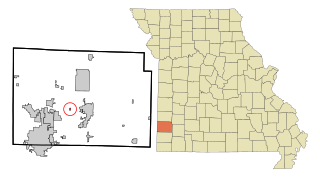
Brooklyn Heights is a village in Jasper County, Missouri, United States. The population was 101 at the 2020 census. It is part of the Joplin, Missouri Metropolitan Statistical Area.

<span class="mw-page-title-main">Vanlue, Ohio</span> Village in Ohio, United States

Vanlue is a village in Hancock County, Ohio, United States. The population was 341 at the 2020 census.

<span class="mw-page-title-main">Long Lake, South Dakota</span> Town in South Dakota, United States

Long Lake is a town in McPherson County, South Dakota, United States. The population was 27 at the 2020 census.

<span class="mw-page-title-main">Lake City, Texas</span> Town in Texas, United States

Lake City is a town in San Patricio County, Texas, United States. The population was 447 at the 2020 census, down from 509 at the 2010 census.

<span class="mw-page-title-main">Pax, West Virginia</span> Town in West Virginia, United States

Pax is a town in Fayette County, West Virginia, United States. The current mayor of Pax is William F. Hughes. The population was 167 at the 2010 census.

<span class="mw-page-title-main">Quinwood, West Virginia</span> Town in West Virginia, United States

Quinwood is a town and former coal town in Greenbrier County, West Virginia, United States. The population was 220 at the 2020 census.

<span class="mw-page-title-main">West Hamlin, West Virginia</span> Town in West Virginia, United States

West Hamlin is a town in Lincoln County, West Virginia, United States, along the Guyandotte River. The population was 519 at the 2020 census, and is now down to 509, according to the 2021 census. West Hamlin is a part of the Huntington-Ashland, WV-KY-OH, Metropolitan Statistical Area (MSA). West Hamlin is west of the county seat at Hamlin, hence the name.

<span class="mw-page-title-main">Ross, Wisconsin</span> Town in Wisconsin, United States

Ross is a town in Forest County, Wisconsin, United States. The population was 132 at the 2020 census. The census-designated place of Newald is located in the town.

<span class="mw-page-title-main">Knowlton, Wisconsin</span> Town in Wisconsin, United States

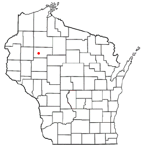
Knowlton is a town in Marathon County, Wisconsin, United States. It is part of the Wausau, Wisconsin Metropolitan Statistical Area. The population was 1,910 at the 2010 census. The unincorporated communities of Dancy and Knowlton are located in the town. The unincorporated communities of Ashley and Rocky Corners are also located partially in the town. The town was created in 1859.

<span class="mw-page-title-main">Crystal Lake, Marquette County, Wisconsin</span> Town in Wisconsin, United States

Crystal Lake is a town in Marquette County, Wisconsin, United States. The population was 513 at the 2000 census. The unincorporated community of Budsin is located in the town.

<span class="mw-page-title-main">Stubbs, Wisconsin</span> Town in Wisconsin, United States

Stubbs is a town in Rusk County, Wisconsin, United States. The population was 587 at the 2000 census. The unincorporated community of Apollonia is located in the town.

<span class="mw-page-title-main">Harrison, Waupaca County, Wisconsin</span> Town in Wisconsin, United States

Harrison is a town in Waupaca County, Wisconsin, United States. The population was 509 at the 2000 census. The unincorporated communities of Northland, Norske, and Schmidt Corner are located in the town.

References

  1. 1 2 "US Board on Geographic Names". United States Geological Survey. October 25, 2007. Retrieved January 31, 2008.
  2. 1 2 "U.S. Census website". United States Census Bureau . Retrieved January 31, 2008.