Viroqua (town), Wisconsin

Last updated

Viroqua, Wisconsin
Vernon County Wisconsin incorporated and unincorporated areas Viroqua (town) highlighted.svg
Location in Vernon County and the state of Wisconsin.
Coordinates: 43°34′37″N90°51′4″W / 43.57694°N 90.85111°W / 43.57694; -90.85111
Country Flag of the United States.svg  United States
State Flag of Wisconsin.svg  Wisconsin
County Vernon
Area
  Total48.4 sq mi (125.3 km2)
  Land48.3 sq mi (125.2 km2)
  Water0.0 sq mi (0.1 km2)
Elevation
[1]
1,198 ft (365 m)
Population
 (2000)
  Total1,560
  Density32.3/sq mi (12.5/km2)
Time zone UTC-6 (Central (CST))
  Summer (DST) UTC-5 (CDT)
Area code 608
FIPS code 55-82950 [2]
GNIS feature ID1584336 [1]

Viroqua is a town in Vernon County, Wisconsin, United States. The population was 1,560 at the 2000 census. The City of Viroqua is located within the town.

Contents

Geography

According to the United States Census Bureau, the town has a total area of 48.4 square miles (125.3 km2), of which, 48.3 square miles (125.2 km2) of it is land and 0.04 square miles (0.1 km2) of it (0.06%) is water.

Demographics

As of the census [2] of 2000, there were 1,560 people, 549 households, and 419 families residing in the town. The population density was 32.3 people per square mile (12.5/km2). There were 603 housing units at an average density of 12.5 per square mile (4.8/km2). The racial makeup of the town was 98.97% White, 0.06% Native American, 0.26% Asian, 0.06% from other races, and 0.64% from two or more races. 0.26% of the population were Hispanic or Latino of any race.

There were 549 households, out of which 34.4% had children under the age of 18 living with them, 66.7% were married couples living together, 5.1% had a female householder with no husband present, and 23.5% were non-families. 19.5% of all households were made up of individuals, and 8.7% had someone living alone who was 65 years of age or older. The average household size was 2.64 and the average family size was 3.04.

In the town, the population was spread out, with 24.9% under the age of 18, 6.4% from 18 to 24, 23.5% from 25 to 44, 27.2% from 45 to 64, and 17.9% who were 65 years of age or older. The median age was 43 years. For every 100 females, there were 98.7 males. For every 100 females age 18 and over, there were 100.5 males.

The median income for a household in the town was $42,583, and the median income for a family was $45,179. Males had a median income of $31,736 versus $23,194 for females. The per capita income for the town was $16,246. About 6.6% of families and 9.7% of the population were below the poverty line, including 15.6% of those under age 18 and 10.0% of those age 65 or over.

Related Research Articles

<span class="mw-page-title-main">Parker City, Indiana</span> Town in Indiana, United States

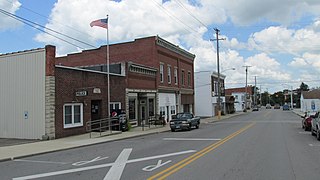
Parker City is a town in Monroe Township, Randolph County, in the U.S. state of Indiana. The population was 1,419 at the 2010 census.

<span class="mw-page-title-main">Rome, Iowa</span> Village in Iowa, United States

Rome is a village in Henry County, Iowa, United States. The population was 114 at the time of the 2020 census.

<span class="mw-page-title-main">Morley, Iowa</span> City in Iowa, United States

Morley is a city in Jones County, Iowa, United States. The population was 96 at the time of the 2020 census. It is part of the Cedar Rapids Metropolitan Statistical Area.

<span class="mw-page-title-main">Westfield, Maine</span> Town in the state of Maine, United States

Westfield is a town in Aroostook County, Maine, United States. The population was 455 at the 2020 census.

<span class="mw-page-title-main">Pownal, Maine</span> Town in Maine, United States

Pownal is a town in Cumberland County, Maine, United States. The population was 1,566 at the 2020 census. It is part of the Portland–South Portland–Biddeford, Maine Metropolitan Statistical Area. Pownal is home to Bradbury Mountain State Park.

<span class="mw-page-title-main">Chesterville, Maine</span> Town in Maine, United States

Chesterville is a town in Franklin County, Maine, United States. The population was 1,328 at the 2020 census.

Chester is a town in Penobscot County, Maine, United States. The population was 549 at the 2020 census.

<span class="mw-page-title-main">Pewamo, Michigan</span> Village in Michigan, United States

Pewamo is a village in Lyons Township, Ionia County in the U.S. state of Michigan. It was founded in 1857 as a station along the Detroit, Grand Haven and Milwaukee Railway. The village name was suggested by J.C. Blanchard in honor of Chief Pewamo, with whom he had hunted along the nearby Grand River. The population was 469 at the 2010 census.

Lake Township is a township in Roseau County, Minnesota, United States. The population was 2,087 at the 2000 census. This township was originally called Algoma Township, which bears a name of Indian derivation, "formed by Schoolcraft from Algonquin and goma meaning 'Algonquin waters.' It designates a large district in Canada, bordering Lakes Huron and Superior. The name was changed sometime between 1954 and 1965.

<span class="mw-page-title-main">New Haven, West Virginia</span> Town in West Virginia, United States

New Haven is a town in Mason County, West Virginia, United States, along the Ohio River. The population was 1,485 at the 2020 census. It is part of the Point Pleasant, WV–OH Micropolitan Statistical Area.

<span class="mw-page-title-main">North Hills, West Virginia</span> Town in West Virginia, United States

North Hills is a town in Wood County, West Virginia, United States. It is a suburb of Parkersburg. The population was 837 at the 2020 census. North Hills was incorporated on February 15, 1979.

<span class="mw-page-title-main">Rutland, Wisconsin</span> Town in Wisconsin, United States

Rutland is a town in Dane County, Wisconsin, United States. The population was 1,977 by the US Census Bureau 2020 census The population was 1,887 at the 2000 census. However, for 2021, the Wisconsin Dept. of Administration declared the population of the Town to be 2,032. The unincorporated communities of Rutland and Stone are located in the town.

<span class="mw-page-title-main">Vermont, Wisconsin</span> Town in Wisconsin, United States

Vermont is a town located in Dane County, Wisconsin, United States. The population was 871 at the 2020 Census. The unincorporated communities of Elvers and Vermont are located in the town.

<span class="mw-page-title-main">Liberty, Grant County, Wisconsin</span> Town in Wisconsin, United States

Liberty is a town in Grant County, Wisconsin, United States. The population was 552 at the 2000 census. The unincorporated community of Stitzer, Wisconsin is in the town. The town was named from the American ideal of liberty.

<span class="mw-page-title-main">Orange, Wisconsin</span> Town in Wisconsin, United States

Orange is a town in Juneau County, Wisconsin, United States. The population was 549 at the 2000 census. The unincorporated communities of Lone Rock and Orange Mill are located in the town.
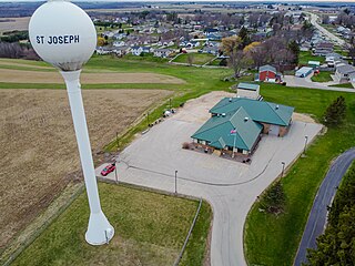
<span class="mw-page-title-main">Center, Rock County, Wisconsin</span> Town in Wisconsin, United States

The Town of Center is located in Rock County, Wisconsin, United States. The population was 1,046 at the 2020 census. The unincorporated community of Center is in the town. The ghost town of Fellows was also located in the town.

<span class="mw-page-title-main">Rushford, Wisconsin</span> Town in Wisconsin, United States

Rushford is a town in Winnebago County, Wisconsin, United States. The population was 1,561 at the 2010 census. The unincorporated communities of Eureka, Island Park, and Waukau are located in the town. The ghost town of Delhi was located in the town.

<span class="mw-page-title-main">Windsor, Wisconsin</span> Village in Wisconsin, United States

Windsor is a village and former town in Dane County, Wisconsin. The population was 8,754 at the time of the 2020 census. The communities of Lake Windsor, Morrisonville, and Token Creek are located within the village. Windsor voted to incorporate as a village on November 3, 2015; prior to its incorporation, it was a town, and a portion of the town was a census-designated place. Windsor is a part of the Census Bureau's Madison metropolitan statistical area.

<span class="mw-page-title-main">Viroqua, Wisconsin</span> City in Wisconsin, United States

Viroqua is the county seat of Vernon County, Wisconsin, United States. The population was 4,504 at the 2020 census. The city is in the town of Viroqua.

<span class="mw-page-title-main">Darien, Wisconsin</span> Village in Wisconsin, United States

Darien is a village in Walworth County, Wisconsin, United States. The population was 1,573 at the 2020 census. The village is located within the Town of Darien.

References

  1. 1 2 "US Board on Geographic Names". United States Geological Survey. October 25, 2007. Retrieved January 31, 2008.
  2. 1 2 "U.S. Census website". United States Census Bureau . Retrieved January 31, 2008.