Red Mound, Wisconsin | |
|---|---|
 | |
 Red Mound, Wisconsin  Red Mound, Wisconsin | |
| Coordinates: 43°28′21″N91°08′41″W / 43.47250°N 91.14472°W | |
| Country | |
| State | |
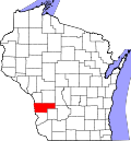
| County | Vernon |
| Elevation | 1,312 ft (400 m) |
| Time zone | UTC-6 (Central (CST)) |
| • Summer (DST) | UTC-5 (CDT) |
| Area code | 608 |
| GNIS feature ID | 1577788 [1] |
Red Mound is an unincorporated community in the Town of Wheatland, Vernon County, Wisconsin, United States. [1] [2]