Franklin, Vernon County, Wisconsin

Last updated

Franklin, Wisconsin
Town of Franklin town hall.jpg
Town of Franklin town hall
Vernon County Wisconsin incorporated and unincorporated areas Franklin highlighted.svg
Location in Vernon County and the state of Wisconsin.
Coordinates: 43°29′2″N90°53′41″W / 43.48389°N 90.89472°W / 43.48389; -90.89472
Country Flag of the United States.svg  United States
State Flag of Wisconsin.svg  Wisconsin
County Vernon
Area
  Total51.6 sq mi (133.6 km2)
  Land51.5 sq mi (133.5 km2)
  Water0.0 sq mi (0.1 km2)
Elevation
[1]
1,158 ft (353 m)
Population
 (2000)
  Total923
  Density17.9/sq mi (6.9/km2)
Time zone UTC-6 (Central (CST))
  Summer (DST) UTC-5 (CDT)
Area code 608
FIPS code 55-27400 [2]
GNIS feature ID1583236 [1]

Franklin is a town in Vernon County, Wisconsin, United States. The population was 923 at the 2000 census. The unincorporated communities of Fargo, Folsom, and Liberty Pole are located in the town.

Contents

Geography

According to the United States Census Bureau, the town has a total area of 51.6 square miles (133.6 km2), of which, 51.5 square miles (133.5 km2) of it is land and 0.04 square miles (0.1 km2) of it (0.08%) is water.

Demographics

As of the census [2] of 2000, there were 923 people, 324 households, and 246 families residing in the town. The population density was 17.9 people per square mile (6.9/km2). There were 382 housing units at an average density of 7.4 per square mile (2.9/km2). The racial makeup of the town was 99.02% White, 0.11% African American, 0.22% Asian, and 0.65% from two or more races. Hispanic or Latino of any race were 0.76% of the population.

There were 324 households, out of which 37.3% had children under the age of 18 living with them, 67.0% were married couples living together, 5.2% had a female householder with no husband present, and 23.8% were non-families. 21.0% of all households were made up of individuals, and 8.3% had someone living alone who was 65 years of age or older. The average household size was 2.85 and the average family size was 3.35.

In the town, the population was spread out, with 33.9% under the age of 18, 4.8% from 18 to 24, 28.3% from 25 to 44, 22.8% from 45 to 64, and 10.3% who were 65 years of age or older. The median age was 35 years. For every 100 females, there were 109.3 males. For every 100 females age 18 and over, there were 111.1 males.

The median income for a household in the town was $32,931, and the median income for a family was $34,511. Males had a median income of $24,861 versus $19,306 for females. The per capita income for the town was $12,850. About 14.5% of families and 21.2% of the population were below the poverty line, including 35.3% of those under age 18 and 11.7% of those age 65 or over.

Related Research Articles

<span class="mw-page-title-main">St. Leon, Indiana</span> Town in Indiana, United States

St. Leon or Saint Leon is a town in Kelso Township, Dearborn County, Indiana, United States. The population was 678 at the 2010 census.

<span class="mw-page-title-main">Bryant, Indiana</span> Town in Indiana, United States

Bryant is a town in Bearcreek Township, Jay County, Indiana, United States. The population was 252 at the 2010 census.

<span class="mw-page-title-main">Edgewood, Iowa</span> City in Iowa, United States

Edgewood is a city in Clayton and Delaware counties in the U.S. state of Iowa. Highway 3, which runs through the center of town, is the dividing line between the two counties. The Edgewood post office was established in 1852 on the Clayton side of the town. Edgewood was formally incorporated in 1892, although it had a functioning council for some time before that date. The population was 909 at the time of the 2020 census, down from 923 in 2000.

<span class="mw-page-title-main">Castle Hill, Maine</span> Town in the state of Maine, United States

Castle Hill is a town in Aroostook County, Maine, United States. The population was 373 people at the 2020 census.

<span class="mw-page-title-main">New Canada, Maine</span> Town in the state of Maine, United States

New Canada is a town in Aroostook County, Maine, United States. The population was 310 at the 2020 census.

<span class="mw-page-title-main">Sherman, Maine</span> Town in the state of Maine, United States

Sherman is a town in Aroostook County, Maine, United States. The population was 815 at the 2020 census.

Sweden is a town in Oxford County, Maine, United States. The population was 406 at the 2020 census. Set among hills, forests and ponds, Sweden includes the village of East Sweden.

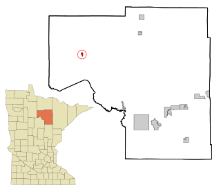
Deer River Township is a township in Itasca County, Minnesota, United States. The population was 704 at the 2010 census.

<span class="mw-page-title-main">Squaw Lake, Minnesota</span> City in Minnesota, United States

Squaw Lake is a city in Itasca County, Minnesota, United States. The population was 98 at the 2020 census.

<span class="mw-page-title-main">Centerview, Missouri</span> Village in Missouri, United States

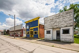
Centerview is a village in Johnson County, Missouri, United States. The population was 267 at the 2010 census.

<span class="mw-page-title-main">Pickering, Missouri</span> Village in Missouri, United States

Pickering is a city in Nodaway County, Missouri, United States. The population was 160 at the 2010 census.

<span class="mw-page-title-main">Vinton, Ohio</span> Village in Ohio, United States

Vinton is a village in Gallia County, Ohio, United States. The population was 224 at the 2020 census. It is part of the rural Point Pleasant micropolitan area.

<span class="mw-page-title-main">Sandy Creek Township, Pennsylvania</span> Township in Pennsylvania, United States

Sandy Creek Township is a township that is located in Mercer County, Pennsylvania, United States. The population was 800 at the time of the 2020 census, an increase from the figure of 795 that was documented in 2010.

<span class="mw-page-title-main">Topsham, Vermont</span> Town in Vermont, United States

Topsham is a town in Orange County, Vermont, United States. The population was 1,199 at the 2020 census. It contains four villages: East Topsham, Topsham Four Corners, Waits River, and West Topsham.

<span class="mw-page-title-main">Burnsville, West Virginia</span> Town in West Virginia, United States

Burnsville is a town in Braxton County, West Virginia, United States, at the confluence of the Little Kanawha River and Saltlick Creek. The population was 401 at the 2020 census. Burnsville was incorporated in 1902 by the Circuit Court and named for Captain John Burns who operated the first sawmill in that section of the state and who established the town shortly after the close of the American Civil War. It was named "All West Virginia City" in 1976.

<span class="mw-page-title-main">Red Springs, Wisconsin</span> Town in Wisconsin, United States

Red Springs is a town in Shawano County, Wisconsin, United States. As of the 2010 census, the town had a total population of 925. The unincorporated community of Morgan is located in the town. The census-designated place of Middle Village is also located partially in the town.

<span class="mw-page-title-main">La Grange, Walworth County, Wisconsin</span> Town in Wisconsin, United States

La Grange is a town in Walworth County, Wisconsin, United States. The population was 2,472 at the 2020 census. The unincorporated communities of Heart Prairie, La Grange, Lauderdale, Lauderdale Lakes, and Lauderdale Shores are located in the town.

<span class="mw-page-title-main">Blackburn, Missouri</span> City in Missouri, United States

Blackburn is a city in Lafayette and Saline counties in the U.S. state of Missouri and is part of the Kansas City metropolitan area. The population was 224 at the 2020 census.

Lowell is a town in Dodge County, Wisconsin, United States. The population was 1,169 at the 2000 census. The Village of Lowell and the unincorporated community of North Lowell are located in the town.

<span class="mw-page-title-main">Millersburg, Indiana</span> Town in Indiana, United States

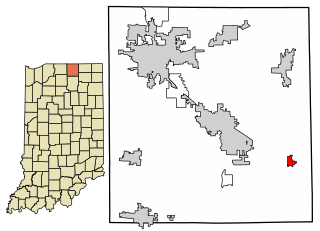
Millersburg is a town in Clinton and Benton townships, Elkhart County, Indiana, United States. The population was 903 at the 2010 census.

References

  1. 1 2 "US Board on Geographic Names". United States Geological Survey. October 25, 2007. Retrieved January 31, 2008.
  2. 1 2 "U.S. Census website". United States Census Bureau . Retrieved January 31, 2008.