Coon, Wisconsin

Last updated

Coon, Wisconsin
Vernon County Wisconsin incorporated and unincorporated areas Coon highlighted.svg
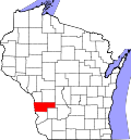
Location in Vernon County and the state of Wisconsin.
Coordinates: 43°41′18″N90°58′49″W / 43.68833°N 90.98028°W / 43.68833; -90.98028
Country Flag of the United States.svg  United States
State Flag of Wisconsin.svg  Wisconsin
County Vernon
Area
  Total34.9 sq mi (90.3 km2)
  Land34.9 sq mi (90.3 km2)
  Water0.0 sq mi (0.0 km2)
Elevation
[1]
1,043 ft (318 m)
Population
 (2000)
  Total683
  Density19.6/sq mi (7.6/km2)
Time zone UTC-6 (Central (CST))
  Summer (DST) UTC-5 (CDT)
Area code 608
FIPS code 55-16875 [2]
GNIS feature ID1583013 [1]
Website http://tn.coon.wi.gov/page/home

Coon is a town in Vernon County, Wisconsin, United States. The population was 683 at the 2000 census.

Contents

Geography

According to the United States Census Bureau, the town has a total area of 34.8 square miles (90.3 km2), all of it land.

Demographics

As of the census [2] of 2000, there were 683 people, 262 households, and 197 families residing in the town. The population density was 19.6 people per square mile (7.6/km2). There were 295 housing units at an average density of 8.5 per square mile (3.3/km2). The racial makeup of the town was 99.56% White, 0.15% Native American, 0.15% from other races, and 0.15% from two or more races. Hispanic or Latino of any race were 0.15% of the population.

There were 262 households, out of which 36.3% had children under the age of 18 living with them, 69.8% were married couples living together, 3.4% had a female householder with no husband present, and 24.8% were non-families. 21.8% of all households were made up of individuals, and 10.3% had someone living alone who was 65 years of age or older. The average household size was 2.61 and the average family size was 3.09.

In the town, the population was spread out, with 26.8% under the age of 18, 4.7% from 18 to 24, 27.4% from 25 to 44, 27.2% from 45 to 64, and 13.9% who were 65 years of age or older. The median age was 40 years. For every 100 females, there were 105.7 males. For every 100 females age 18 and over, there were 110.1 males.

The median income for a household in the town was $41,364, and the median income for a family was $50,568. The median income for males was $30,917 and $22,813 for females. The per capita income for the town was $20,460. About 5.3% of families and 8.1% of the population were below the poverty line, including 8.9% of those under age 18 and 11.7% of those age 65 or over.

Related Research Articles

<span class="mw-page-title-main">Grand Isle, Maine</span> Town in the state of Maine, United States

Grand Isle is a town in Aroostook County, Maine, United States. The population was 366 at the 2020 census. The village of Grand Isle is in the northwestern part of the town.

Lee is a town in Penobscot County, Maine, United States. It was incorporated in 1832. The town was originally called Mattekeunk, but changed it to Lee to give it n English name. Stephen Lee suggested the town be named Lee after Revolutionary general Henry "High Horse" Lee. To further convince the townsfolk, he brought a barrel of rum to the meeting. The population was 916 at the 2020 census. Lee has been home to Lee Academy since 1845.

Ripley is a town in Somerset County, Maine, United States. The community was named after Brigadier General Eleazer Wheelock Ripley of the War of 1812. The population was 484 at the 2020 census.

<span class="mw-page-title-main">Whitneyville, Maine</span> Town in the state of Maine, United States

Whitneyville is a town in Washington County, Maine, United States. The town was named after Colonel Joseph Whitney, a mill owner. The population was 202 at the 2020 census.

<span class="mw-page-title-main">Kelliher, Minnesota</span> Town in Minnesota, United States

Kelliher is a city in Beltrami County, Minnesota, United States. The population was 258 at the 2020 census. Minnesota State Highway 72 is the primary route through Kelliher.

<span class="mw-page-title-main">Spring Brook Township, Lackawanna County, Pennsylvania</span> Place in Pennsylvania, United States

Spring Brook Township is a township in Lackawanna County, Pennsylvania, United States. The population was 2,753 at the 2020 census.

<span class="mw-page-title-main">Grantsville, West Virginia</span> Town in West Virginia, United States

Grantsville is a town in Calhoun County, West Virginia, United States. The population was 482 at the 2020 census. It is the county seat of Calhoun County. The town was established along the Little Kanawha River in 1865 and named for Ulysses S. Grant. Grantsville is home to Wayne Underwood Park, which includes a .25-mile-long (0.40 km) walking trail, and to the annual West Virginia Wood Festival.

<span class="mw-page-title-main">White Hall, West Virginia</span> Town in West Virginia, United States

White Hall is a town in Marion County, West Virginia, United States. The population was 706 at the 2020 census. Incorporated in 1989, White Hall is adjacent to the county seat, Fairmont, and is part of the Fairmont, West Virginia, Micropolitan Statistical Area. White Hall has many different stores and restaurants.

<span class="mw-page-title-main">Iaeger, West Virginia</span> Town in West Virginia, United States

Iaeger is a town in McDowell County, West Virginia, United States. The population was 257 at the 2020 census.

<span class="mw-page-title-main">Gilbert, West Virginia</span> Town in West Virginia, United States

Gilbert is a town in Mingo County, West Virginia, United States, along the Guyandotte River. The population was 450 at the 2010 census. Gilbert was incorporated in 1918 and named for Gilbert Creek, which derives its name from the name of an early traveler in the area who was killed by Native Americans. Gilbert is known nationwide for the Hatfield-McCoy ATV Trails that are located in the area. There are a number of lodges and restaurants in Gilbert.

<span class="mw-page-title-main">Durbin, West Virginia</span> Town in West Virginia, United States

Durbin is a town in Pocahontas County, West Virginia, United States. The population was 235 at the 2020 census.

<span class="mw-page-title-main">Stanfold, Wisconsin</span> Town in Wisconsin, United States

Stanfold is a town in Barron County in the U.S. state of Wisconsin. The population was 719 at the 2010 census.

<span class="mw-page-title-main">Bell, Wisconsin</span> Town in Bayfield County, Wisconsin, United States

Bell is a town in Bayfield County, Wisconsin, United States. The population was 263 at the 2010 census. The unincorporated community of Cornucopia is located within the town.

<span class="mw-page-title-main">York, Dane County, Wisconsin</span> Town in Wisconsin, United States

h Town of York is located in Dane County, Wisconsin, United States. The population was 697 at the 2020 census. The unincorporated community of York Center is located in the town.

<span class="mw-page-title-main">Chase, Wisconsin</span> Town in Wisconsin, United States

Chase is a town in Oconto County, Wisconsin The population was 2,082 at the time of the 2000 census. The unincorporated communities of Chase and South Chase are located in the town. The unincorporated community of Krakow is also located partially in the town.

<span class="mw-page-title-main">Waukechon, Wisconsin</span> Town in Wisconsin, United States

Waukechon is a town in Shawano County, Wisconsin, United States. The population was 928 at the 2000 census. The unincorporated community of Lunds is located in the town. Its Menominee name is Wākecānāpāēw, meaning "crooked beak man", a reference to the Thunderbird Clan of the Ho-Chunk.

<span class="mw-page-title-main">Caledonia, Trempealeau County, Wisconsin</span> Town in Wisconsin, United States

Caledonia is a town in Trempealeau County, Wisconsin, United States. The population was 928 at the 2020 census.

<span class="mw-page-title-main">Washington, Vilas County, Wisconsin</span> Town in Wisconsin, United States

Washington is a town in Vilas County, Wisconsin, United States. The population was 1,577 at the 2000 census.

Withee is a town in Clark County in the U.S. state of Wisconsin. The population was 885 at the 2000 census. The unincorporated community of Lombard is located in the town.

<span class="mw-page-title-main">Genoa (town), Wisconsin</span> Human settlement in Vernon County, Wisconsin, United States of America

Genoa is a town in Vernon County, Wisconsin, United States. The population was 705 at the 2000 census. The Village of Genoa is located within the town. The unincorporated community of Romance is located in the town of Genoa.

References

  1. 1 2 "US Board on Geographic Names". United States Geological Survey. October 25, 2007. Retrieved January 31, 2008.
  2. 1 2 "U.S. Census website". United States Census Bureau . Retrieved January 31, 2008.