Chaseburg, Wisconsin

Last updated
Chaseburg, Wisconsin
Vernon County Wisconsin Incorporated and Unincorporated areas Chaseburg Highlighted.svg
Location of Chaseburg in Vernon County, Wisconsin.
Coordinates: 43°39′21″N91°5′50″W / 43.65583°N 91.09722°W / 43.65583; -91.09722 Coordinates: 43°39′21″N91°5′50″W / 43.65583°N 91.09722°W / 43.65583; -91.09722
Country Flag of the United States.svg  United States
State Flag of Wisconsin.svg  Wisconsin
County Vernon
Government
  MayorKen Bluske
Area
[1]
  Total0.85 sq mi (2.21 km2)
  Land0.84 sq mi (2.18 km2)
  Water0.01 sq mi (0.02 km2)
Elevation
[2]
709 ft (216 m)
Population
 (2010) [3]
  Total284
  Estimate 
(2019) [4]
292
  Density346.38/sq mi (133.74/km2)
Time zone UTC-6 (Central (CST))
  Summer (DST) UTC-5 (CDT)
Area code 608
FIPS code 55-14150 [5]
GNIS feature ID1562965 [2]

Chaseburg is a village in Vernon County, Wisconsin, United States. The population was 284 at the 2010 census.

Contents

Geography

Chaseburg is located at 43°39′21″N91°5′50″W / 43.65583°N 91.09722°W / 43.65583; -91.09722 (43.655890, -91.097095). [6] According to the United States Census Bureau, the village has a total area of 0.93 square miles (2.41 km2), of which, 0.92 square miles (2.38 km2) of it is land and 0.01 square miles (0.03 km2) is water. [7] Chaseburg is split into two distinct sections, upper and lower. Upper Chaseburg is populated by a residential area, gas station, and a couple bars. Lower Chaseburg consists of a few homes. Lower Chaseburg has a public grounds area with Tuffy Pond and open walkspace. Prior to the flood of 2007 lower Chaseburg was a major area of activity. There was a bank, grocery store, several bars, and more homes.

Demographics

Historical population
CensusPop.Note
1880 125
1930 218
1940 25818.3%
1950 219−15.1%
1960 24210.5%
1970 224−7.4%
1980 27924.6%
1990 36530.8%
2000 306−16.2%
2010 284−7.2%
2019 (est.)292 [4] 2.8%
U.S. Decennial Census [8]
2014 Estimate [9]

2010 census

As of the census [3] of 2010, there were 284 people, 121 households, and 75 families living in the village. The population density was 308.7 inhabitants per square mile (119.2/km2). There were 126 housing units at an average density of 137.0 per square mile (52.9/km2). The racial makeup of the village was 96.5% White, 0.4% Asian, 1.8% from other races, and 1.4% from two or more races. Hispanic or Latino of any race were 1.8% of the population.

There were 121 households, of which 31.4% had children under the age of 18 living with them, 49.6% were married couples living together, 9.1% had a female householder with no husband present, 3.3% had a male householder with no wife present, and 38.0% were non-families. 32.2% of all households were made up of individuals, and 14.1% had someone living alone who was 65 years of age or older. The average household size was 2.35 and the average family size was 3.00.

The median age in the village was 40.5 years. 25.4% of residents were under the age of 18; 7.6% were between the ages of 18 and 24; 25% were from 25 to 44; 24% were from 45 to 64; and 18% were 65 years of age or older. The gender makeup of the village was 54.2% male and 45.8% female.

2000 census

As of the census [5] of 2000, there were 306 people, 133 households, and 80 families living in the village. The population density was 492.4 people per square mile (190.6/km2). There were 146 housing units at an average density of 234.9 per square mile (90.9/km2). The racial makeup of the village was 100.00% White.

There were 133 households, out of which 30.1% had children under the age of 18 living with them, 52.6% were married couples living together, 3.8% had a female householder with no husband present, and 39.8% were non-families. 33.8% of all households were made up of individuals, and 17.3% had someone living alone who was 65 years of age or older. The average household size was 2.30 and the average family size was 2.99.

In the village, the population was spread out, with 25.2% under the age of 18, 6.2% from 18 to 24, 30.1% from 25 to 44, 22.2% from 45 to 64, and 16.3% who were 65 years of age or older. The median age was 37 years. For every 100 females, there were 114.0 males. For every 100 females age 18 and over, there were 108.2 males.

The median income for a household in the village was $38,438, and the median income for a family was $45,417. Males had a median income of $28,125 versus $25,469 for females. The per capita income for the village was $18,851. About 3.8% of families and 7.9% of the population were below the poverty line, including 2.5% of those under the age of eighteen and 20.0% of those 65 or over.

Notable people

Related Research Articles

<span class="mw-page-title-main">Port Heiden, Alaska</span> City in Alaska, United States

Port Heiden is a city in Lake and Peninsula Borough, Alaska, United States. As of the 2020 census, the population of the city is 100, slightly down from 102 in 2010.

<span class="mw-page-title-main">Shirley, Arkansas</span> Town in Arkansas, United States

Shirley is a town in northeast Van Buren County, Arkansas, United States, along the Middle Fork of the Little Red River. A one-time railroad outpost, the community today is oriented toward agriculture and recreational activities due to the river and Greers Ferry Lake. The population was 223 at the 2010 census.

<span class="mw-page-title-main">Apple River, Illinois</span> Village in Illinois, United States

Apple River is a village in Jo Daviess County, Illinois, United States. The population was 366 at the 2010 census, down from 379 in 2000.

<span class="mw-page-title-main">Mount Sterling, Wisconsin</span> Village in Wisconsin, United States

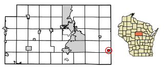
Mount Sterling is a village in Crawford County, Wisconsin, United States. The population was 211 at the 2010 census.

<span class="mw-page-title-main">St. Cloud, Wisconsin</span> Village in Wisconsin, United States

St. Cloud is a village in Fond du Lac County, Wisconsin, United States, along the Sheboygan River. The population was 477 at the 2010 census. St. Cloud is part of The Holyland region in northeastern Fond du Lac County.

<span class="mw-page-title-main">Blue River, Wisconsin</span> Village in Wisconsin, United States

Blue River is a village in Grant County, Wisconsin, United States. The population was 434 at the 2010 census.

<span class="mw-page-title-main">Tennyson, Wisconsin</span> Village in Wisconsin, United States

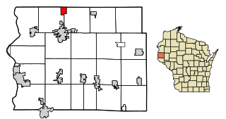
Tennyson is a village in Grant County, Wisconsin, United States, originally called Dutch Hollow. The population was 355 at the 2010 census.

<span class="mw-page-title-main">La Farge, Wisconsin</span> Village in Wisconsin, United States

La Farge is a village along the Kickapoo River in Vernon County, Wisconsin, United States. The population was 746 at the 2010 census.

<span class="mw-page-title-main">Dorchester, Wisconsin</span> Village in Wisconsin, United States

Dorchester is a village in Clark and Marathon counties in the U.S. state of Wisconsin, along the 45th parallel. It is part of the Wausau, Wisconsin Metropolitan Statistical Area. The population was 876 at the 2010 census. Of this, 871 were in Clark County, and only 5 were in Marathon County.

<span class="mw-page-title-main">Montfort, Wisconsin</span> Village in Wisconsin, United States

Montfort is a village in Grant and Iowa Counties in the U.S. state of Wisconsin. The population was 718 at the 2010 census. Of this, 622 were in Grant County, and 96 were in Iowa County.

<span class="mw-page-title-main">Cazenovia, Wisconsin</span> Village in Wisconsin, United States

Cazenovia is a village in Richland and Sauk Counties in the U.S. state of Wisconsin. The population was 318 at the 2010 census. Of this, 314 were in Richland County, and only 4 were in Sauk County.

<span class="mw-page-title-main">Cherry Creek (hamlet), New York</span> Hamlet and CDP in New York, United States

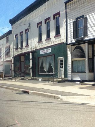
Cherry Creek is a hamlet in Chautauqua County, New York, United States. The population was 461 at the 2010 census, when it was an incorporated village. The hamlet is within the town of Cherry Creek near the east border of the county. It is located on New York State Route 83 and a stream called Cherry Creek.

<span class="mw-page-title-main">Wyocena, Wisconsin</span> Village in Wisconsin, United States

Wyocena is a village in Columbia County, Wisconsin, United States. The population was 768 at the 2010 census. The village is located within the Town of Wyocena. It is part of the Madison Metropolitan Statistical Area.

<span class="mw-page-title-main">Lowell, Wisconsin</span> Village in Wisconsin, United States

Lowell is a village in Dodge County, Wisconsin, United States, along the Beaver Dam River. The population was 340 at the 2010 census. The village is located within the Town of Lowell.

<span class="mw-page-title-main">Superior (village), Wisconsin</span> Village in Wisconsin, United States

The Village of Superior is a village in Douglas County, Wisconsin, United States. The population was 664 at the 2010 census. The village is located within the Town of Superior and is located immediately south of and adjacent to the City of Superior.

<span class="mw-page-title-main">Melrose, Wisconsin</span> Village in Wisconsin, United States

Melrose is a village in Jackson County, Wisconsin, United States. The population was 503 at the 2010 census. The village is located within the Town of Melrose.

<span class="mw-page-title-main">Necedah, Wisconsin</span> Village in Wisconsin, United States

Necedah is a village in Juneau County, Wisconsin, United States. The population was 916 at the 2010 census. The village is located within the Town of Necedah.

<span class="mw-page-title-main">Elderon, Wisconsin</span> Village in Wisconsin, United States

Elderon is a village in Marathon County, Wisconsin, United States. It is part of the Wausau, Wisconsin Metropolitan Statistical Area. The population was 179 at the 2010 census.

<span class="mw-page-title-main">Star Prairie, Wisconsin</span> Village in Wisconsin, United States

Star Prairie is a village in St. Croix County in the U.S. state of Wisconsin. The population was 561 at the 2010 census. The village is located along the Apple River on the boundary between the Town of Star Prairie and the Town of Stanton.

<span class="mw-page-title-main">Scandinavia, Wisconsin</span> Village in Wisconsin, United States

Scandinavia is a village in the Town of Scandinavia in Waupaca County, Wisconsin, United States. The population was 328 at the 2010 census.

References

  1. "2019 U.S. Gazetteer Files". United States Census Bureau. Retrieved August 7, 2020.
  2. 1 2 "US Board on Geographic Names". United States Geological Survey. 2007-10-25. Retrieved 2008-01-31.
  3. 1 2 "U.S. Census website". United States Census Bureau . Retrieved 2012-11-18.
  4. 1 2 "Population and Housing Unit Estimates". United States Census Bureau. May 24, 2020. Retrieved May 27, 2020.
  5. 1 2 "U.S. Census website". United States Census Bureau . Retrieved 2008-01-31.
  6. "US Gazetteer files: 2010, 2000, and 1990". United States Census Bureau. 2011-02-12. Retrieved 2011-04-23.
  7. "US Gazetteer files 2010". United States Census Bureau. Archived from the original on 2012-01-25. Retrieved 2012-11-18.
  8. United States Census Bureau. "Census of Population and Housing" . Retrieved August 22, 2014.
  9. "Population Estimates". United States Census Bureau. Archived from the original on 2015-05-22. Retrieved June 7, 2015.
  10. 'Wisconsin Blue Book 1885,' Biographical Sketch of Joseph W. Hoyt, pg. 420