Stark, Wisconsin

Last updated

Stark, Wisconsin
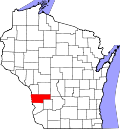
Vernon County Wisconsin incorporated and unincorporated areas Stark highlighted.svg
Location in Vernon County and the state of Wisconsin.
Coordinates: 43°35′44″N90°36′35″W / 43.59556°N 90.60972°W / 43.59556; -90.60972
Country Flag of the United States.svg  United States
State Flag of Wisconsin.svg  Wisconsin
County Vernon
Area
  Total34.4 sq mi (89.2 km2)
  Land34.4 sq mi (89.1 km2)
  Water0.0 sq mi (0.0 km2)
Elevation
[1]
1,243 ft (379 m)
Population
 (2000)
  Total349
  Density10.1/sq mi (3.9/km2)
Time zone UTC-6 (Central (CST))
  Summer (DST) UTC-5 (CDT)
Area code 608
FIPS code 55-76725 [2]
GNIS feature ID1584213 [1]

Stark is a town in Vernon County, Wisconsin, United States. The population was 349 at the 2000 census. The unincorporated community of Tunnelville is located partially in the town.

Contents

Geography

According to the United States Census Bureau, the town has a total area of 34.4 square miles (89.2 km2), of which, 34.4 square miles (89.1 km2) of it is land and 0.03% is water.

Demographics

As of the census [2] of 2000, there were 349 people, 138 households, and 100 families residing in the town. The population density was 10.1 people per square mile (3.9/km2). There were 198 housing units at an average density of 5.8 per square mile (2.2/km2). The racial makeup of the town was 99.14% White, 0.86% from other races. Hispanic or Latino of any race were 0.57% of the population.

There were 138 households, out of which 26.1% had children under the age of 18 living with them, 67.4% were married couples living together, 3.6% had a female householder with no husband present, and 27.5% were non-families. 22.5% of all households were made up of individuals, and 9.4% had someone living alone who was 65 years of age or older. The average household size was 2.53 and the average family size was 2.96.

In the town, the population was spread out, with 24.1% under the age of 18, 6.3% from 18 to 24, 19.5% from 25 to 44, 36.7% from 45 to 64, and 13.5% who were 65 years of age or older. The median age was 45 years. For every 100 females, there were 105.3 males. For every 100 females age 18 and over, there were 115.4 males.

The median income for a household in the town was $44,167, and the median income for a family was $48,393. Males had a median income of $27,250 versus $23,750 for females. The per capita income for the town was $17,966. About 18.7% of families and 20.1% of the population were below the poverty line, including 40.0% of those under age 18 and 23.8% of those age 65 or over.

Related Research Articles

<span class="mw-page-title-main">Dyer Brook, Maine</span> Town in the state of Maine, United States

Dyer Brook is a town in Aroostook County, Maine, United States. The population was 215 at the 2020 census. Dyer Brook is also host to the local school, Southern Aroostook Community School.

LaGrange is a town in Penobscot County, Maine, United States. The population was 635 at the 2020 census.

<span class="mw-page-title-main">Galestown, Maryland</span> Town in Maryland, United States

Galestown is a town in Dorchester County, Maryland, United States. The population was 138 at the 2010 census.

<span class="mw-page-title-main">New Melle, Missouri</span> City in Missouri, United States

New Melle is a small city in St. Charles County, Missouri, United States. It is located approximately 38 miles west of St. Louis. The population was 475 at the 2010 census.

<span class="mw-page-title-main">Macon, North Carolina</span> Town in North Carolina, United States

Macon is a town located in Warren County, North Carolina, United States. As of the 2010 census, the town had a total population of 119. It is named for Nathaniel Macon, long-time Speaker of the U.S. House of Representatives.

<span class="mw-page-title-main">McVille, North Dakota</span> City in North Dakota, United States

McVille is a city in Nelson County, North Dakota, United States. The population was 392 at the 2020 census. McVille was founded in 1906.

<span class="mw-page-title-main">Gratis, Ohio</span> Village in Ohio, United States

Gratis is a village in Preble County, Ohio, United States. The population was 842 at the 2020 census. It is part of the Dayton Metropolitan Statistical Area.

<span class="mw-page-title-main">Yale, South Dakota</span> Town in South Dakota, United States

Yale is an incorporated town in Beadle County, South Dakota, United States. The population was 112 at the 2020 census.

<span class="mw-page-title-main">Peterstown, West Virginia</span> Town in West Virginia, United States

Peterstown is a town in Monroe County, West Virginia, United States. The population was 456 at the 2020 census.

<span class="mw-page-title-main">Bancroft, West Virginia</span> Town in West Virginia, United States

Bancroft is a town in Putnam County, West Virginia, United States, along the Kanawha River. The population was 389 at the 2020 census. It is part of the Huntington–Ashland metropolitan area.

<span class="mw-page-title-main">Rhodell, West Virginia</span> Unincorporated community in West Virginia, United States

Rhodell is an unincorporated community in Raleigh County, West Virginia, United States. The population was 173 at the 2010 census.

<span class="mw-page-title-main">Hendricks, West Virginia</span> Town in West Virginia, United States

Hendricks is a town in Tucker County, West Virginia, United States. The population was 226 at the 2020 census. The Blackwater River and the Dry Fork join at Hendricks to form the Black Fork, a principal tributary of the Cheat River.

<span class="mw-page-title-main">Hughes, Wisconsin</span> Town in Wisconsin, United States

Hughes is a town in Bayfield County, Wisconsin, United States. The population was 383 at the 2010 census. The unincorporated communities of Muskeg and Wills are located in the town.

<span class="mw-page-title-main">Levis, Wisconsin</span> Town in Wisconsin, United States

Levis is a town in Clark County in the U.S. state of Wisconsin. The population was 504 at the 2000 census.

<span class="mw-page-title-main">Friesland, Wisconsin</span> Village in Wisconsin, United States

Friesland is a village in Columbia County, Wisconsin, United States. The population was 320 at the 2020 census. It is part of the Madison Metropolitan Statistical Area, and was named after Friesland, one of the twelve provinces of the Netherlands.

<span class="mw-page-title-main">Spruce, Wisconsin</span> Town in Wisconsin, United States

Spruce is a town in Oconto County, Wisconsin, United States. The population was 835 at the 2010 census.

<span class="mw-page-title-main">Elk, Wisconsin</span> Town in Wisconsin, United States

Elk is a town in Price County, Wisconsin, United States. The population was 1,183 at the 2000 census.

<span class="mw-page-title-main">Hill, Wisconsin</span> Town in Wisconsin, United States

Hill is a town in Price County, Wisconsin, United States. The population was 366 at the 2020 census. Timms Hill, the highest point in Wisconsin, is located in the town of Hill.

<span class="mw-page-title-main">South Oxford, Maine</span> Unorganized territory in Maine, United States

South Oxford is an unorganized territory located in Oxford County, Maine, United States. The population was 591 at the 2020 census. The unorganized territory encompasses the areas designated under state law as Albany Township, Mason Township, and Batchelder's Grant. Albany and Mason were formerly incorporated as towns. Albany disincorporated in 1937 while Mason disincorporated in 1935.

<span class="mw-page-title-main">Black Earth (town), Wisconsin</span>

The Town of Black Earth is located in Dane County, Wisconsin, United States. The population was 510 at the 2020 census.

References

  1. 1 2 "US Board on Geographic Names". United States Geological Survey. October 25, 2007. Retrieved January 31, 2008.
  2. 1 2 "U.S. Census website". United States Census Bureau . Retrieved January 31, 2008.