| Willow Mountain | |
|---|---|
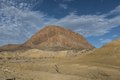
 Southwest aspect | |
| Highest point | |
| Elevation | 3,826 ft (1,166 m) [1] |
| Prominence | 824 ft (251 m) [1] |
| Parent peak | Wildhorse Mountain (3,980 ft) [2] |
| Isolation | 2.63 mi (4.23 km) [2] |
| Coordinates | 29°21′55″N103°30′57″W / 29.3653572°N 103.5157089°W [3] |
| Geography | |
 Willow Mountain Location of Willow Mountain in Texas  Willow Mountain Willow Mountain (the United States) | |
| Country | United States |
| State | Texas |
| County | Brewster |
| Parent range | Christmas Mountains [1] |
| Topo map | USGS Terlingua |
| Geology | |
| Rock age | Eocene |
| Mountain type | Volcanic plug |
| Rock type | Igneous rock |
Willow Mountain is a 3,826-foot-elevation (1,166-meter) summit in Brewster County, Texas, United States.