Wilton, Minnesota

Last updated
Wilton
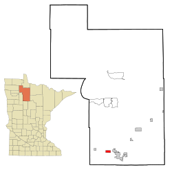
Beltrami County Minnesota Incorporated and Unincorporated areas Wilton Highlighted.svg
Location of Wilton, Minnesota
Coordinates: 47°30′22″N94°59′46″W / 47.50611°N 94.99611°W / 47.50611; -94.99611 Coordinates: 47°30′22″N94°59′46″W / 47.50611°N 94.99611°W / 47.50611; -94.99611
Country United States
State Minnesota
County Beltrami
Area
[1]
  Total2.88 sq mi (7.47 km2)
  Land2.80 sq mi (7.24 km2)
  Water0.09 sq mi (0.23 km2)
Elevation
1,391 ft (424 m)
Population
 (2020)
  Total263
  Density94.06/sq mi (36.32/km2)
Time zone UTC-6 (Central (CST))
  Summer (DST) UTC-5 (CDT)
ZIP codes
56601, 56687
Area code 218
FIPS code 27-70708 [2]
GNIS feature ID0654239 [3]

Wilton is a city in Beltrami County, Minnesota, United States. The population was 204 at the 2010 census. [4] Wilton is considered a bedroom community of Bemidji.

Contents

Geography

According to the United States Census Bureau, the city has a total area of 2.37 square miles (6.14 km2), of which 2.32 square miles (6.01 km2) is land and 0.05 square miles (0.13 km2) is water. [5]

Demographics

Historical population
CensusPop.
1880 87
1910 215
1920 176−18.1%
1930 155−11.9%
1940 139−10.3%
1950 108−22.3%
1960 1123.7%
1970 1196.3%
1980 17647.9%
1990 171−2.8%
2000 1868.8%
2010 2049.7%
2020 26328.9%
U.S. Decennial Census [6]

2010 census

As of the census [7] of 2010, there were 204 people, 78 households, and 55 families living in the city. The population density was 87.9 inhabitants per square mile (33.9/km2). There were 87 housing units at an average density of 37.5 per square mile (14.5/km2). The racial makeup of the city was 91.7% White, 1.5% Native American, 1.5% Asian, and 5.4% from two or more races. Hispanic or Latino of any race were 1.0% of the population.

There were 78 households, of which 38.5% had children under the age of 18 living with them, 51.3% were married couples living together, 14.1% had a female householder with no husband present, 5.1% had a male householder with no wife present, and 29.5% were non-families. 20.5% of all households were made up of individuals, and 7.7% had someone living alone who was 65 years of age or older. The average household size was 2.62 and the average family size was 3.02.

The median age in the city was 35.7 years. 24% of residents were under the age of 18; 9.8% were between the ages of 18 and 24; 21.5% were from 25 to 44; 33.3% were from 45 to 64; and 11.3% were 65 years of age or older. The gender makeup of the city was 55.9% male and 44.1% female.

2000 census

As of the census [2] of 2000, there were 186 people, 73 households, and 54 families living in the city. The population density was 80.1 inhabitants per square mile (30.9/km2). There were 80 housing units at an average density of 34.5 per square mile (13.3/km2). The racial makeup of the city was 97.31% White, 1.08% Native American, and 1.61% from two or more races. Hispanic or Latino of any race were 1.61% of the population.

There were 73 households, out of which 37.0% had children under the age of 18 living with them, 53.4% were married couples living together, 12.3% had a female householder with no husband present, and 26.0% were non-families. 20.5% of all households were made up of individuals, and 8.2% had someone living alone who was 65 years of age or older. The average household size was 2.55 and the average family size was 2.91.

In the city, the population was spread out, with 28.5% under the age of 18, 8.1% from 18 to 24, 29.6% from 25 to 44, 22.6% from 45 to 64, and 11.3% who were 65 years of age or older. The median age was 36 years. For every 100 females, there were 111.4 males. For every 100 females age 18 and over, there were 95.6 males.

The median income for a household in the city was $33,750, and the median income for a family was $37,083. Males had a median income of $17,500 versus $20,750 for females. The per capita income for the city was $13,432. About 8.0% of families and 14.7% of the population were below the poverty line, including 26.5% of those under the age of eighteen and none of those 65 or over.
Related Research Articles

<span class="mw-page-title-main">Eagle, Idaho</span> City in Idaho, United States

Eagle is a city in Ada County, Idaho, 10 miles northwest of Boise. The population was 30,346 at the time of the 2020 census.

<span class="mw-page-title-main">Van Horne, Iowa</span> City in Iowa, United States

Van Horne is a city in Benton County, Iowa, United States. The population was 774 at the 2020 census. It is part of the Cedar Rapids Metropolitan Statistical Area.

<span class="mw-page-title-main">Lewis, Iowa</span> City in Iowa, United States

Lewis is a city in Cass County, Iowa, United States, along the East Nishnabotna River. The population was 357 at the time of the 2020 census.

<span class="mw-page-title-main">Woodburn, Iowa</span> City in Iowa, United States

Woodburn is a city in Clarke County, Iowa, United States. The population was 146 at the time of the 2020 census.

<span class="mw-page-title-main">Colesburg, Iowa</span> City in Iowa, United States

Colesburg is a city in Delaware County, Iowa, United States. The population was 386 at the time of the 2020 census.

<span class="mw-page-title-main">Orleans, Iowa</span> City in Iowa, United States

Orleans is a city in Dickinson County, Iowa, United States. The population was 521 at the time of the 2020 census. Orleans is part of the Iowa Great Lakes region, located along Spirit Lake. Numerous state parks are located within a few miles of the town, including Marble Beach and Mini-Wakan.

<span class="mw-page-title-main">Craig, Iowa</span> City in Iowa, United States

Craig is a city in Plymouth County, Iowa, United States. The population was 79 at the 2020 census.

<span class="mw-page-title-main">Diagonal, Iowa</span> City in Iowa, United States

Diagonal is a city in northwest Ringgold County, Iowa, United States. The population was 344 at the time of the 2020 census.

<span class="mw-page-title-main">Dixon, Iowa</span> City in Iowa, USA

Dixon is a city in Scott County, Iowa, United States. The population was 202 at the time of the 2020 census.

<span class="mw-page-title-main">Chickamaw Beach, Minnesota</span> City in Minnesota, United States

Chickamaw Beach is a city in Cass County, Minnesota, United States. The population was 114 at the 2010 census. It is part of the Brainerd Micropolitan Statistical Area.

<span class="mw-page-title-main">Hampton, Minnesota</span> City in Minnesota, United States

Hampton is a city in Dakota County, Minnesota, United States. The population was 689 at the 2010 census.

<span class="mw-page-title-main">Sunburg, Minnesota</span> City in Minnesota, United States

Sunburg is a city in Kandiyohi County, Minnesota, United States. The population was 100 at the 2010 census.

<span class="mw-page-title-main">Pine Springs, Minnesota</span> City in Minnesota, United States

Pine Springs is a city in Washington County, Minnesota, United States. The population was 408 at the 2010 census.

<span class="mw-page-title-main">Lamar Heights, Missouri</span> Village in Missouri, United States

Lamar Heights is a village in Barton County, Missouri, United States. The population was 170 at the 2020 census.

<span class="mw-page-title-main">Pleasant Hope, Missouri</span> City in Missouri, United States

Pleasant Hope is a city in Polk County, Missouri, United States. The population was 614 at the 2010 census. It is part of the Springfield, Missouri Metropolitan Statistical Area.

<span class="mw-page-title-main">Oakland, Missouri</span> City in Missouri, United States

Oakland is a city in St. Louis County, Missouri, United States. The population was 1,381 at the 2010 census.

<span class="mw-page-title-main">Sublimity, Oregon</span> City in Oregon, United States

Sublimity is a city in Marion County, Oregon, United States. The population was 2,681 at the 2010 census. It is part of the Salem Metropolitan Statistical Area.

<span class="mw-page-title-main">War, West Virginia</span> City in West Virginia, United States

War is a city in McDowell County, West Virginia, United States. The population was 690 at the 2020 census. War was incorporated in 1920 by the Circuit Court of McDowell County. Its name is derived from War Creek, whose confluence with Dry Fork is located within the city. War is the only place in the United States with this name. War was formerly known as Miner's City. It is also known for being a setting in the movie October Sky; as writer Homer Hickam's Big Creek High School.

<span class="mw-page-title-main">Bay City, Wisconsin</span> Village in Wisconsin, United States

Bay City is a village on the Mississippi River in Pierce County, Wisconsin, United States. The population was 500 at the 2010 census.

<span class="mw-page-title-main">Minneiska, Minnesota</span> City in Minnesota, United States

Minneiska is a city in Wabasha and Winona counties in the U.S. state of Minnesota. The population was 111 at the 2010 census.

References

  1. "2020 U.S. Gazetteer Files". United States Census Bureau. Retrieved July 24, 2022.
  2. 1 2 "U.S. Census website". United States Census Bureau . Retrieved 2008-01-31.
  3. "US Board on Geographic Names". United States Geological Survey. 2007-10-25. Retrieved 2008-01-31.
  4. "2010 Census Redistricting Data (Public Law 94-171) Summary File". American FactFinder. U.S. Census Bureau, 2010 Census. Retrieved 23 April 2011.[ dead link ]
  5. "US Gazetteer files 2010". United States Census Bureau . Retrieved 2012-11-13.
  6. "Census of Population and Housing". Census.gov. Retrieved June 4, 2015.
  7. "U.S. Census website". United States Census Bureau . Retrieved 2012-11-13.