Winchester Mountain Lookout

Last updated
Winchester Mountain Lookout
Winchester Lookout 100806.jpg
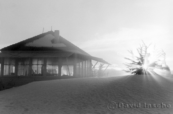
Winchester Lookout (from the southwest)
USA Washington location map.svg
Red pog.svg
LocationMt Baker Ranger District, Whatcom County, Washington
Coordinates 48°57′24″N121°38′35″W / 48.95655°N 121.64313°W / 48.95655; -121.64313
Built1935
MPS USDA Forest Service Fire Lookouts on Mt. Baker--Snoqualmie National Forest TR
NRHP reference No. 87001188 [1]
Added to NRHPJuly 14, 1987

The historical Winchester Lookout, located in the North Cascades in the U.S. state of Washington, provides views of the Northern Picket Range, Mount Baker, Mount Shuksan, Mount Larrabee, and Canadian peaks. The steep snowfields usually require an ice-axe well into July. The Twin Lakes road may not be passable to the trailhead which will add 2 miles (3.2 km) to the hike. Volunteers from the Mount Baker Club maintain the lookout with 2 work parties per year. [2]

Contents

The lookout is open to the public for day or overnight use on a first-come first-served basis. Fires are not permitted at all.

History

Winchester Mountain was named in the early 1900s by prospector Jack Post for the rifle he was carrying. [3] This L-4 cab fire lookout was built in 1935 and staffed until 1966. The lookout was slated for demolition when in 1982 the Mount Baker Club, led by Gary Haufle, worked out a deal with the Forest Service to restore the lookout. The Forest Service provided the materials and the club provided all of the labor.

National Register

The lookout was added to the National Register of Historic Places on July 14, 1987, [4] and is also on the National Historic Lookout Register.

Winchester Mountain Lookout (added 1987 - Structure - #87001188)

Mt. Baker Wilderness Area overlooking the north fork of Nooksack River and west fork of Silesia Creek, Sedro Woolley
Historic Significance: Event, Architecture/Engineering
Area of Significance: Architecture, Conservation, Politics/Government
Period of Significance: 1925-1949
Owner: Federal
Historic Function: Government
Historic Sub-function: Fire Station
Current Function: Government
Current Sub-function: Fire Station
Mt. Baker-Snoqualmie National Forest 15 miles (24 km) northeast of Mt. Baker Whatcom County, Washington Elevation 6,521 feet (1,988 m)

Visiting

Winchester Mountain in 1999 with view of Goat Mountain and Mount Shuksan The top of Winchester Mountain.jpg
Winchester Mountain in 1999 with view of Goat Mountain and Mount Shuksan

The lookout is generally inaccessible from early October until mid summer due to snow. If you plan to spend the night in the lookout be aware that it may be occupied when you arrive. There are areas outside the lookout to pitch a tent, or sleep under the stars with no tent. There are 2 bunks in the lookout for overnighters. Propane may be available, provided by the club, but all visitors should arrive prepared with the essentials. A snowfield that lasts late into the summer is behind the lookout and provides a water source. Boil all water.

The Trail

The trailhead for trail #685 to the top of Winchester Mountain is located between the two Twin Lakes. The steep trail, with a 1,300-foot (400 m) elevation gain, starts in beautiful tall treed forest with fantastic wildflower filled clearings and climbs high into the rough windswept and delicate alpine. There are two very narrow sections of trail with long drops that require sure footing are not for the faint of heart. The trail is 2.1 miles (3.4 km) one-way and rated "more difficult" by the U.S. Forest Service. [5]

The lookout is located within the Mount Baker Wilderness area. Wilderness area regulations restrict group size to no more than 12 persons. [6]

The Road

Winchester Mountain reflected in Twin Lakes Winchester Mountain and the northern Twin Lake.jpg
Winchester Mountain reflected in Twin Lakes

The trail head is accessed by the Twin Lakes Road (Forest Service #3065 in the North Fork Nooksack area) off of the Mt Baker Highway. The first 4.5 miles (7.2 km) to the Tomyhoi Lake/Yellow Aster Butte trailhead is well maintained. The remaining 2 miles (3.2 km) of road is not maintained and can only be driven at about 5–15 miles per hour (8–24 km/h) by 4x4 vehicles with high clearance. The unmaintained portion of road is often washed out in the early part of the season and is only fixed up by the miners at the Lone Jack Mine, provided they decide to operate the mine that year based on the price of gold.

Related Research Articles

<span class="mw-page-title-main">Mount Baker–Snoqualmie National Forest</span> Protected area in the United States

The Mount Baker–Snoqualmie National Forest in Washington is a National Forest extending more than 140 miles (230 km) along the western slopes of the Cascade Range from the Canada–US border to the northern boundary of Mount Rainier National Park. Administered by the United States Forest Service, the forest is headquartered in Everett. There are local ranger district offices in North Bend and Skykomish.

<span class="mw-page-title-main">Mount Shuksan</span> Mountain in Washington state, United States

Mount Shuksan is a glaciated massif in the North Cascades National Park. Shuksan rises in Whatcom County, Washington immediately to the east of Mount Baker, and 11.6 miles (18.7 km) south of the Canada–US border. The mountain's name Shuksan is derived from the Lummi word [šéqsən], said to mean "high peak". The highest point on the mountain is a three-sided peak known as Summit Pyramid.

<span class="mw-page-title-main">Nooksack River</span> River in Washington state, United States

The Nooksack River is a river in western Whatcom County of the northwestern U.S. state of Washington, draining extensive valley systems within the North Cascades around Mount Shuksan, Mount Baker and the Twin Sisters, and a portion of Fraser Lowland south of the Canada–United States border.

<span class="mw-page-title-main">Angeles National Forest</span> National forest in California, United States

The Angeles National Forest (ANF) of the U.S. Forest Service is located in the San Gabriel Mountains and Sierra Pelona Mountains, primarily within Los Angeles County in southern California. The ANF manages a majority of the San Gabriel Mountains National Monument.

<span class="mw-page-title-main">Washington State Route 542</span> Highway in Washington

State Route 542 (SR 542) is a 57.24-mile-long (92.12 km) state highway in the U.S. state of Washington, serving Mount Baker in Whatcom County. SR 542 travels east as the Mount Baker Highway from an interchange with Interstate 5 (I-5) in Bellingham through the Nooksack River valley to the Mt. Baker Ski Area at Austin Pass. It serves as the main highway to Mount Baker and the communities of Deming, Kendall, and Maple Falls along the Nooksack River. The highway was constructed in 1893 by Whatcom County as a wagon road between Bellingham and Maple Falls and was added to the state highway system as a branch of State Road 1 in 1925. The branch was transferred to Primary State Highway 1 (PSH 1) during its creation in 1937 and became SR 542 during the 1964 highway renumbering.

<span class="mw-page-title-main">Henry M. Jackson Wilderness</span> Protected area in the United States

The Henry M. Jackson Wilderness is a 103,297-acre (41,803 ha) designated wilderness area in the state of Washington, United States. The area lies adjacent to the southwest corner of the Glacier Peak Wilderness, northwest of Stevens Pass on U.S. Highway 2 and northeast of the town of Skykomish, Washington. Wild Sky Wilderness is located immediately southwest of the Henry M. Jackson Wilderness. While the wilderness straddles the Cascade Mountain Range, most of it is in the westside ecotype. The wilderness lies in parts of Snoqualmie, Mount Baker, and Wenatchee national forests.

<span class="mw-page-title-main">Alpine Lakes Wilderness</span> Wilderness area in Washington (state)

The Alpine Lakes Wilderness is a large wilderness area spanning the Central Cascades of Washington state in the United States. The wilderness is located in parts of Wenatchee National Forest and Snoqualmie National Forest, and is approximately bounded by Interstate 90 and Snoqualmie Pass to the south and U.S. Route 2 and Stevens Pass to the north. The Alpine Lakes is the largest wilderness area near the population centers of Puget Sound, counted at 414,161 acres (167,605 ha) following the 2014 expansion.

<span class="mw-page-title-main">Norse Peak Wilderness</span> Wilderness area in central Washington

Norse Peak Wilderness is a 52,315-acre (21,171 ha) designated wilderness area located in central Washington in the United States. It protects the portion of the Cascade Range north of Chinook Pass, south of Naches Pass, and east of Mount Rainier National Park. It is bordered by the William O. Douglas Wilderness to the south. The wilderness is named for a prominent peak which overlooks Crystal Mountain Ski Area. Roughly triangular, it is about 10 miles (16 km) across and contains no roads.

<span class="mw-page-title-main">Mount Baker Wilderness</span>

Mount Baker Wilderness is a 119,989-acre (48,558 ha) wilderness area within the Mount Baker-Snoqualmie National Forest in the western Cascade Range of northern Washington state. Its eastern border is shared with the boundary of the Stephen Mather Wilderness and North Cascades National Park for a distance of 40 miles. The wilderness extends from State Route 20 north to the Canada–US border. On the west, it is bounded by the foothills of the Puget Sound lowlands.

<span class="mw-page-title-main">Big Four Ice Caves</span> Mountain with the lowest glacier in the continental United States

Big Four Mountain is a mountain in the Cascade Range of Washington, located 21 miles (34 km) east of Granite Falls. The mountain is about 6,180 ft (1,880 m) high. At the bottom of its steep, 4,200 ft (1,300 m) high north face, debris piles form from avalanches and are able to remain there year round because of the continuous shade provided by the mountain. At an elevation between 2,450 ft (750 m) and 1,950 ft (590 m), this ice forms the lowest-elevation glacier in the lower 49 states. During the summer, snow-melt streams flow beneath the debris piles and cause caves to be formed in the ice.

<span class="mw-page-title-main">Boulder River Wilderness</span> Protected area in Washington state, U.S.

Boulder River Wilderness is a 48,674-acre (197 km2) wilderness area within the Mount Baker-Snoqualmie National Forest in the western Cascade Range of Washington state.

<span class="mw-page-title-main">Mount Larrabee</span> Mountain in Washington (state), United States

Mount Larrabee is a 7,865-foot (2,397-metre) Skagit Range mountain summit situated 1.4 mile south of the Canada–United States border, in the North Cascades of Washington state. It is located immediately southeast of American Border Peak within the Mount Baker Wilderness, which is part of the Mount Baker-Snoqualmie National Forest, and near North Cascades National Park. It is notable for its reddish coloring caused by oxidation of Iron in the rock. The rock consists of reddish interbedded and interfolded phyllites and greenstone. Originally known as Red Mountain, the name was changed in 1951 to honor Charles F. Larrabee (1895–1950), of the prominent Larrabee family of Bellingham, Washington. The name was officially adopted in 1951 by the U.S. Board on Geographic Names.

<span class="mw-page-title-main">Tomyhoi Peak</span> Mountain in Washington (state), United States

Tomyhoi Peak is a 7,439-foot (2,267-metre) Skagit Range mountain situated one mile south of the Canada–United States border, in the North Cascades of Washington state. It is located west of Mount Larrabee and within the Mount Baker Wilderness, which is part of the Mount Baker-Snoqualmie National Forest. This mountain's name was officially adopted in 1913 by the U.S. Board on Geographic Names.

<span class="mw-page-title-main">Ruth Mountain</span> Mountain in Washington (state), United States

Ruth Mountain is a 7,115 ft (2,170 m) Skagit Range summit located two miles south of Hannegan Pass in the North Cascades of Washington state. The name honors Ruth Cleveland, daughter of President Grover Cleveland. This mountain's name was officially adopted in 1952 by the United States Board on Geographic Names. Ruth Mountain is situated on the shared border of North Cascades National Park and the Mount Baker Wilderness, which is part of the Mount Baker-Snoqualmie National Forest. The summit offers views of Mount Shuksan, East Nooksack Glacier, Seahpo Peak, Nooksack Tower, Icy Peak, Mount Sefrit, Mineral Mountain, and the Picket Range. The melting and receding Ruth Glacier on the north slope of Ruth creates the headwaters for the Chilliwack River. Precipitation runoff also finds its way into the Nooksack and Baker Rivers.

<span class="mw-page-title-main">Mount Sefrit</span> Mountain in Washington (state), United States

Mount Sefrit is a 7,191 ft (2,190 m) Skagit Range summit located three miles north of Mount Shuksan in the North Cascades of Washington state. It is situated in the Mount Baker Wilderness, which is managed by the Mount Baker-Snoqualmie National Forest. The summit offers views of Mount Shuksan, Mount Baker, and the Picket Range. Mount Sefrit's name honors Frank Ira Sefrit (1867–1950), editor and publisher of The Bellingham Herald for nearly 40 years. This mountain's name was officially adopted in 1952 by the U.S. Board on Geographic Names. Precipitation runoff from the mountain drains into the deep valleys of Ruth Creek and the Nooksack River which nearly encircle Mount Sefrit, except for Nooksack Ridge which connects it to Ruth Mountain.

<span class="mw-page-title-main">Table Mountain (Whatcom County, Washington)</span> Mountain in Washington (state), United States

Table Mountain is a Skagit Range summit located west of Mount Shuksan and northeast of Mount Baker in the North Cascades of Washington state. It is situated in the Mount Baker Wilderness, which is managed by the Mount Baker-Snoqualmie National Forest. Table Mountain is located west of Artist Point, at the end of the Mount Baker Highway. From the Artist Point parking lot, a short 1.4 mile trail leads to the summit at the west end of the mountain. The summit offers views of Mount Shuksan, Mount Baker, Mount Hermann, and Mount Larrabee. Remnants of the Table Mountain Glacier are on the northeast slope. Precipitation runoff from the mountain drains into tributaries of the Skagit and Nooksack Rivers.

<span class="mw-page-title-main">Hidden Lake Peaks</span> Mountain in Washington (state), United States

Hidden Lake Peaks is series of peaks with a maximum elevation of 7,088 feet that are located in the North Cascades, in Skagit County of Washington state. The peaks extend three miles southwest from the nearest higher peak called The Triad. Situated on the western boundary of North Cascades National Park, Hidden Lake Peaks are positioned west of the crest of the Cascade Range, approximately ten miles east of the town of Marblemount. The popular subsidiary peak, Hidden Lake Lookout (6890 ft), lies a half mile to the southwest of the highest summit. The mountain's name is taken from its proximity to Hidden Lake which lies in a cirque below the east aspect of these two main peaks. Precipitation runoff from Hidden Lake Peaks drains into Cascade River which is a tributary of the Skagit River.

<span class="mw-page-title-main">Hannegan Peak</span> Mountain in Washington (state), United States

Hannegan Peak is a 6,191-foot elevation (1,887 m) mountain summit located in the Skagit Range, which is a subset of the North Cascades in Whatcom County of Washington state. It is situated immediately north of Hannegan Pass, and 2.2 mi (3.5 km) north of Ruth Mountain in the Mount Baker Wilderness, which is managed by Mount Baker-Snoqualmie National Forest. Banning Austin and R.M. Lyle made the first ascent of Hannegan Peak in 1893 while surveying for a possible road across the Cascades over Hannegan Pass to Whatcom Pass. This peak was named in association with Hannegan Pass, which in turn was named for Tom Hannegan, State Road Commissioner at that time. Although no road was built, a four-mile trail leads hikers to the pass, and another one-mile path leads to the summit. Peaks which can be seen from the summit include Mount Shuksan, Ruth Mountain, Mineral Mountain, Mount Baker, Mount Sefrit, Mount Larrabee, Granite Mountain, Mount Chardonnay, Mount Rexford, the Picket Range, and many more.

<span class="mw-page-title-main">Yellow Aster Butte</span> Mountain in Washington, United States of America

Yellow Aster Butte is a 6,241-foot (1,902-metre) Skagit Range summit located three miles south of the Canada–United States border, in Whatcom County of Washington state. It is situated within the Mount Baker Wilderness, on land managed by Mount Baker-Snoqualmie National Forest. The nearest higher neighbor is Winchester Mountain, 1.77 miles (2.85 km) to the east, and Mount Larrabee is set 2.3 miles (3.7 km) to the northeast. The summit offers views of Mount Larrabee, Tomyhoi Peak, American Border Peak, Canadian Border Peak, Mount Shuksan, and Mount Baker. Precipitation runoff on the north side of the mountain drains into Tomyhoi Creek, whereas the west side of the mountain drains into Damfino Creek, and the south slope is drained by Swamp Creek.

<span class="mw-page-title-main">Mount Ann</span> Mountain in Washington (state), United States

Mount Ann is a 5,840-foot-elevation (1,780-meter) mountain summit located in the North Cascades in Whatcom County of Washington state. It is set within the Mount Baker Wilderness, on land managed by Mount Baker-Snoqualmie National Forest, and is only one mile outside the boundary of North Cascades National Park. Mount Ann is situated immediately southwest of line parent Mount Shuksan and northeast of Mount Baker. Mount Ann can be seen south of Artist Point which is at the end of the Mount Baker Highway. Precipitation runoff from the mountain drains into Swift Creek and Shuksan Creek, which empty into Baker Lake. Topographic relief is significant as the west aspect rises 3,200 feet above Swift Creek in approximately one mile. The mountain is unofficially named in association with nearby Lake Ann. Due to its proximity to the Mt. Baker Ski Area, Mount Ann is a winter destination for skiing and snowshoeing.

References

  1. "National Register Information System". National Register of Historic Places . National Park Service. April 15, 2008.
  2. "Mount Baker Club". Mount Baker Club. 2011-12-28. Retrieved 2012-04-19.
  3. Majors, Harry M. (1975). Exploring Washington. Van Winkle Publishing Co. p. 30. ISBN   978-0-918664-00-6.
  4. Whatcom County listings at National Register of Historic Places
  5. "Winchester Mountain Trail #685 Mt. Baker-Snoqualmie National Forest". U.S. Forest Service . Retrieved 2012-04-19.
  6. "Mt. Baker-Snoqualmie National Forest Wilderness Regulations". U.S. Forest Service. Retrieved 2012-04-19.