Winthrop, Iowa

Last updated
Winthrop, Iowa
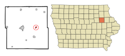
Buchanan County Iowa Incorporated and Unincorporated areas Winthrop Highlighted.svg
Location of Winthrop, Iowa
Coordinates: 42°28′21″N91°44′9″W / 42.47250°N 91.73583°W / 42.47250; -91.73583 Coordinates: 42°28′21″N91°44′9″W / 42.47250°N 91.73583°W / 42.47250; -91.73583
Country Flag of the United States.svg  United States
State Flag of Iowa.svg  Iowa
County Buchanan
Government
  MayorGerald Dennie as of 2011 [1]
Area
[2]
  Total0.79 sq mi (2.05 km2)
  Land0.79 sq mi (2.05 km2)
  Water0.00 sq mi (0.00 km2)
Elevation
1,053 ft (321 m)
Population
 (2020)
  Total823
  Density1,040.46/sq mi (401.83/km2)
Time zone UTC-6 (Central (CST))
  Summer (DST) UTC-5 (CDT)
ZIP code
50682
Area code 319
FIPS code 19-86565
GNIS feature ID0463139
Website www.cityofwinthrop.com

Winthrop is a city in Buchanan County, Iowa, United States. The population was 823 at the time of the 2020 census. [3]

Contents

History

Winthrop was platted in 1857. [4]

Geography

Winthrop is located at 42°28′21″N91°44′9″W / 42.47250°N 91.73583°W / 42.47250; -91.73583 (42.472419, -91.735713). [5]

According to the United States Census Bureau, the city has a total area of 0.84 square miles (2.18 km2), all land. [6]

Winthrop is located north of U.S. Route 20.

Demographics

Historical populations
YearPop.±%
1880 320    
1890 370+15.6%
1900 618+67.0%
1910 529−14.4%
1920 507−4.2%
1930 496−2.2%
1940 546+10.1%
1950 604+10.6%
1960 649+7.5%
1970 750+15.6%
1980 767+2.3%
1990 742−3.3%
2000 772+4.0%
2010 850+10.1%
2020 823−3.2%
Source: "U.S. Census website". United States Census Bureau . Retrieved 2020-03-29. and Iowa Data Center
Source:
U.S. Decennial Census [7] [3]

2010 census

As of the census [8] of 2010, there were 850 people, 346 households, and 228 families living in the city. The population density was 1,011.9 inhabitants per square mile (390.7/km2). There were 357 housing units at an average density of 425.0 per square mile (164.1/km2). The racial makeup of the city was 98.7% White, 0.1% Native American, 0.2% Asian, 0.1% from other races, and 0.8% from two or more races. Hispanic or Latino of any race were 0.4% of the population.

There were 346 households, of which 31.8% had children under the age of 18 living with them, 52.3% were married couples living together, 9.0% had a female householder with no husband present, 4.6% had a male householder with no wife present, and 34.1% were non-families. 28.9% of all households were made up of individuals, and 14.5% had someone living alone who was 65 years of age or older. The average household size was 2.46 and the average family size was 3.00.

The median age in the city was 38.5 years. 27.5% of residents were under the age of 18; 5.7% were between the ages of 18 and 24; 24.2% were from 25 to 44; 26.7% were from 45 to 64; and 16% were 65 years of age or older. The gender makeup of the city was 50.0% male and 50.0% female.

2000 census

As of the census [9] of 2000, there were 772 people, 327 households, and 206 families living in the city. The population density was 1,330.9 inhabitants per square mile (513.9/km2). There were 341 housing units at an average density of 587.9 per square mile (227.0/km2). The racial makeup of the city was 99.09% White, 0.39% Native American, 0.26% from other races, and 0.26% from two or more races. Hispanic or Latino of any race were 0.39% of the population.

There were 327 households, out of which 30.6% had children under the age of 18 living with them, 52.0% were married couples living together, 8.3% had a female householder with no husband present, and 37.0% were non-families. 33.9% of all households were made up of individuals, and 17.7% had someone living alone who was 65 years of age or older. The average household size was 2.35 and the average family size was 3.01.

25.5% were under the age of 18, 8.7% from 18 to 24, 27.5% from 25 to 44, 22.2% from 45 to 64, and 16.2% were 65 years of age or older. The median age was 38 years. For every 100 females, there were 91.1 males. For every 100 females age 18 and over, there were 84.3 males.

The median income for a household in the city was $36,136, and the median income for a family was $42,969. Males had a median income of $31,641 versus $22,500 for females. The per capita income for the city was $19,183. About 4.3% of families and 5.7% of the population were below the poverty line, including 6.3% of those under age 18 and 7.8% of those age 65 or over.

Education

Winthrop is home to the East Buchanan Community School District, which also covers the communities of Quasqueton, Aurora, and Monti. The district operates an interconnected elementary school, middle school, and high school. [10]

Notable people

Related Research Articles

<span class="mw-page-title-main">Taft Heights, California</span> Census-designated place in California, United States

Taft Heights is a census-designated place (CDP) in Kern County, California, United States. Taft Heights is located 1 mile (1.6 km) west-southwest of Taft, at an elevation of 1,178 feet (359 m). The population was 1,949 at the 2010 census, up from 1,865 at the 2000 census.

<span class="mw-page-title-main">Lamont, Iowa</span> City in Iowa, United States

Lamont is a city in Buchanan County, Iowa, United States. The population was 429 at the time of the 2020 census.

<span class="mw-page-title-main">Rowley, Iowa</span> City in Iowa, United States

Rowley is a city in Buchanan County, Iowa, United States. The population was 270 at the time of the 2020 census.

<span class="mw-page-title-main">Lake City, Iowa</span> City in Iowa, United States

Lake City is a city in Calhoun County, Iowa, United States, founded in 1856. The population was 1,731 at the time of the 2020 census. The sign coming into town proudly proclaims that Lake City has "Everything but a Lake."

<span class="mw-page-title-main">St. Olaf, Iowa</span> City in Iowa, United States

St. Olaf is a city in Clayton County, Iowa, United States. The population was 106 at the time of the 2020 census, down from 136 in 2000. Swiss Valley has a large cheese packaging plant in St. Olaf.

<span class="mw-page-title-main">Colesburg, Iowa</span> City in Iowa, United States

Colesburg is a city in Delaware County, Iowa, United States. The population was 386 at the time of the 2020 census.

<span class="mw-page-title-main">Masonville, Iowa</span> City in Iowa, United States

Masonville is a city in Delaware County, Iowa, United States. The population was 99 at the time of the 2020 census. The city is located on the western border between Delaware and Buchanan counties.

<span class="mw-page-title-main">West Burlington, Iowa</span> City in Iowa, United States

West Burlington is a city in Des Moines County, Iowa, United States, adjacent to the Mississippi River city of Burlington. The population was 2,968 at the 2010 census. It is part of the Burlington, IA–IL Micropolitan Statistical Area.

<span class="mw-page-title-main">Luxemburg, Iowa</span> City in Iowa, United States

Luxemburg is a city in Dubuque County, Iowa, United States. It is part of the Dubuque, Iowa Metropolitan Statistical Area. The population was 245 at the time of the 2020 census, down from 246 in 2000. The White Pine Hollow State Forest is located four miles to the northwest of Luxemburg.

<span class="mw-page-title-main">Maynard, Iowa</span> City in Iowa, United States

Maynard is a city in Fayette County, Iowa, United States. The population was 476 at the time of the 2020 census.

<span class="mw-page-title-main">St. Lucas, Iowa</span> City in Iowa, United States

St. Lucas is a city in Fayette County, Iowa, United States. The population was 167 at the time of the 2020 census.

<span class="mw-page-title-main">Hills, Iowa</span> City in Iowa, United States

Hills is a city in Johnson County, Iowa, United States. It is part of the Iowa City, Iowa Metropolitan Statistical Area. The population was 863 at the time of the 2020 census. It is part of the Iowa City Community School District.

<span class="mw-page-title-main">Shueyville, Iowa</span> City in Iowa, United States

Shueyville is a city in Johnson County, Iowa, United States. It is part of the Iowa City, Iowa Metropolitan Statistical Area. The population was 731 at the time of the 2020 census.

<span class="mw-page-title-main">Onslow, Iowa</span> City in Iowa, United States

Onslow is a city in Jones County, Iowa, United States. The population was 201 at the time of the 2020 census. It is part of the Cedar Rapids Metropolitan Statistical Area.

<span class="mw-page-title-main">Wyoming, Iowa</span> City in Iowa, United States

Wyoming is a city in Jones County, Iowa, United States. The population was 523 at the time of the 2020 census. It is part of the Cedar Rapids Metropolitan Statistical Area.

<span class="mw-page-title-main">Kinross, Iowa</span> City in Iowa, United States

Kinross is a city in Keokuk County, Iowa, United States. The population was 80 at the time of the 2020 census. The community is named after Kinross in Scotland.

<span class="mw-page-title-main">Prairieburg, Iowa</span> City in Iowa, United States

Prairieburg is a city in Linn County, Iowa, United States. The population was 160 at the time of the 2020 census. It is part of the Cedar Rapids Metropolitan Statistical Area.

<span class="mw-page-title-main">Springville, Iowa</span> City in Iowa, United States

Springville is a city in Linn County, Iowa, United States. The population was 1,154 at the time of the 2020 census. It is part of the Cedar Rapids Metropolitan Statistical Area.

<span class="mw-page-title-main">Ainsworth, Iowa</span> Place in Iowa, United States

Ainsworth is a city in Washington County, Iowa, United States. It is a part of the Iowa City, Iowa Metropolitan Statistical Area. The population was 511 at the 2020 census. It is part of the Highland Community School District.

<span class="mw-page-title-main">West Chester, Iowa</span> City in Iowa, United States

West Chester is a city in Washington County, Iowa, United States. It is part of the Iowa City, Iowa Metropolitan Statistical Area. The population was 144 at the time of the 2020 census.

References

  1. "Winthrop / City". City of Winthrop. Retrieved 2011-09-24.
  2. "2020 U.S. Gazetteer Files". United States Census Bureau. Retrieved March 16, 2022.
  3. 1 2 "2020 Census State Redistricting Data". census.gov. United states Census Bureau. Retrieved 12 August 2021.
  4. History of Byron Township
  5. "US Gazetteer files: 2010, 2000, and 1990". United States Census Bureau. 2011-02-12. Retrieved 2011-04-23.
  6. "US Gazetteer files 2010". United States Census Bureau . Retrieved 2012-05-11.
  7. "Census of Population and Housing". Census.gov. Retrieved June 4, 2015.
  8. "U.S. Census website". United States Census Bureau . Retrieved 2012-05-11.
  9. "U.S. Census website". United States Census Bureau . Retrieved 2008-01-31.
  10. "EAST BUCHANAN" (PDF). Iowa Department of Education . Retrieved 2020-08-23.