Related Research Articles

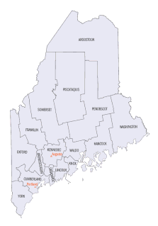
There are approximately 1,600 properties and districts listed on the National Register of Historic Places in the U.S. State of Maine. Each of the state's 16 counties has more than forty listings on the National Register.

The Mount Elizabeth Archeological Site, also known as Racey's Tuckahoe, St. Joseph's Novitiate or the Mount Elizabeth Indian Mound is a prehistoric midden and an archaeological site in Jensen Beach, Florida. It is located in Martin County's Indian RiverSide Park, which includes the former Florida Institute of Technology east of Indian River Drive on the Indian River Lagoon. On September 14, 2002, it was added to the National Register of Historic Places.
The Lamoreau Site, also known as the Maine Archaeological Survey Site 23.13 is an historic archaeological site in Auburn, Maine. It is located on the grounds of the Auburn/Lewiston Municipal Airport. The site was listed on the National Register of Historic Places in 1989. It is named for its discoverer, Henry Lamoreau.

The Big Ram Site, designated Site 36.32 by the Maine Archeological Survey, is a prehistoric archaeological site on Ram Island, an island in the Androscoggin River in Turner, Maine. The site, excavated in 1987, yielded ceramic and other artifacts dating to two periods of occupation, c. 100–600 CE, and c. 1400–1700 CE. The site was listed on the National Register of Historic Places in 1992.
The Cape Site, designated Site 36.27 by the Maine Archaeological Survey, is a prehistoric archaeological site in West Leeds, Maine. Finds at the well-stratified waterfront site include ceramic fragments, stone tools, and remains of habitation dating as far as 6000 BCE. The site was listed on the National Register of Historic Places in 1992.
The Quartz Scraper Site, designated 36.29 by the Maine Archaeological Survey, is a prehistoric archaeological site in the Keens Mills area of Turner, Maine. The site has yielded evidence of human habitation, including contact-period ceramic fragments and European trade beads.

This is a list of the National Register of Historic Places listings in Androscoggin County, Maine.

Allen Island or Allen's Island is a 450-acre (180 ha) private island which is part of St. George, Knox County, Maine. it is located near the southeastern end of Muscongus Bay, roughly midway between the southernmost parts of the St. George's mainland, and Monhegan Island.
The Rumford Archaeological Sites are a collection of prehistoric Native American sites in the vicinity of the Androscoggin River near Rumford, Maine. These six sites provide a window of observation into the movements and practices of Native Americans from c. 7,000 BCE to the Late Woodland period and contact with Europeans. These sites are the subject of three separate listings on the National Register of Historic Places in 1972: the Rumford Falls I-IV Sites, the Rumford V Site, and the Town of Rumford Site. The locations of these sensitive sites are not generally publicized.
The Clarke and Lake Company Archeological Site encompasses all that is left of a historic colonial settlement in Arrowsic, Maine. The site, located on the banks of the Sasanoa River on the northern part of Arrowsic Island, was the local headquarters of the business enterprises operated by Major Thomas Clarke and Captain Thomas Lake. Clarke and Lake were successful merchants and businessmen based in Boston, who at their height claimed more than 450 square miles (120,000 ha) of territory in the Kennebec River watershed, in addition to land holdings and business interests elsewhere. They acquired Arrowsic Island, and established their settlement c. 1654, eventually building a large manor house, warehouse, gristmill and sawmill, and numerous other outbuildings. They developed a small community on the island, with farms and shops, and managed the civic business of the area. Their business included trade with the local Native Americans, fishing, lumbering, and the raising of cattle for shipment to Boston.
The Pejepscot Site is a prehistoric archaeological site on the banks of the Androscoggin River in Topsham, Maine. The site is a small Native American habitation site dating to the Late Woodland or Early Contact period. It was discovered in the 1980s during planning for a water power project on the river above the Pejepscot Dam.

The Caratunk Falls Archeological District is a complex of prehistoric and historic archaeological sites in the Solon, Maine area. First identified in the 1960s as archaeologically significant, the site was mapped by state archaeologists in the early 1980s. At that time it was the single largest complex of archaeological significance in interior Maine, encompassing a period of human activity from the Archaic to the European contact period. The 16-acre (6.5 ha) area was listed on the National Register of Historic Places in 1986.
The Sebec-Piscataquis River Confluence Prehistoric Archeological District encompasses a collection of important prehistoric archaeological sites in Milo, Maine. Located near the mouth of the Sebec River where it meets the Piscataquis River, these sites include several deeply stratified sites covering 5,000 years of history dating back to 8,300 BCE. The area was listed on the National Register of Historic Places in 1986.
The Atkinson-Koskinen Site, designated 45.13 by the Maine Archaeological Survey, is a prehistoric archaeological site in or near Steuben, Maine. Its main feature is a non-shell refuse midden, a rarity on the coast of eastern Maine. Along with the Goddard Site in Brooklin, it is important in analyzing land use and subsistence patterns during the Late Ceramic period. The site was listed on the National Register of Historic Places in 1984.
The Devils Head Site, designated Site 97.10 by the Maine Archaeological Survey, is a prehistoric and historic archaeological site in Calais, Maine. Located on the banks of the St. Croix River, it is a shell midden site with evidence of multiple periods of human habitation, from the Middle Ceramic Period to the Late Contact Period and beyond. With its location near Saint Croix Island, the site of an early French settlement in 1604, the site's finds may provide insight into early French-Native relations in the area. The site was listed on the National Register of Historic Places in 2006.
The eastern part of the United States state of Maine is known to have historically significant examples of prehistoric and historic rock art. The easternmost shore, particularly the shores and islands of Machias Bay, contain one of the greatest concentrations of rock art on the east coast of North America, with creation dates estimated to range from c. 1000 BCE to beyond the European contact period. Many of these sites are listed on the United States National Register of Historic Places.
Archeological Site No. 74-2 is a prehistoric site in Indian Island, Maine. Located on a terrace above the Penobscot River, the site dates to the Middle Archaic Period, a rarity in Maine, made even more unusual by the absence of later period artifacts. The site was listed on the National Register of Historic Places in 1984, for its potential to increase what is known about Native settlement patterns in the area.

The John Chapman Village Site is a prehistoric archaeological site located in the Apple River Valley south of Hanover, Illinois. The site includes a village area and a platform mound; the latter is the only known platform mound in the Apple River Valley. The village was occupied from roughly 1100 to 1250 A.D., toward the end of the Late Woodland period and the beginning of the Mississippian period; it is associated with a transitional phase between the two periods known as the Bennett Phase. Archaeologists have hypothesized that the site formed part of a trade network between Cahokia and settlements further north, such as Aztalan, as evidenced by the artifacts found at the site.

The Hunter Site, designated 15.110 by the Maine Historic Preservation Commission and also known as the Hunter Farm Site, is a prehistoric archaeological site on the banks of the Androscoggin River in Topsham, Maine. The site, located on the Hunter family farm in eastern Topsham, is a Late Archaic Native American habitation site, dating to 4000–5000 years before present. Finds at the site include calcined fragments of fish bones, indicative that the inhabitants' diet included striped bass and sturgeon. Stone tools, including projectile points, have also been found at the site.

The Purinton Family Farm is a historic farmstead at 65 Elm Street in Topsham, Maine. Including three buildings dating to the late 18th and early 19th centuries, it is a rare surviving example in the state of an early 19th-century unconnected farm complex. The property also includes the archaeological remains of an earlier settler's house, as well as prehistoric artifacts. It was listed on the National Register of Historic Places in 1989.
References
- 1 2 "National Register Information System". National Register of Historic Places . National Park Service. April 15, 2008.
- ↑ "Multiple Property Submission for Androscoggin River Drainage Prehistoric Sites". National Park Service. Retrieved 2017-11-14.