
Shaker Heights is a city in Cuyahoga County, Ohio, United States. As of the 2010 Census, the city population was 28,448. Shaker Heights is an inner-ring streetcar suburb of Cleveland, abutting the eastern edge of the city's limits. In July 1911, a petition by property owners was successful in detaching a long strip of land from the south of Cleveland Heights, to be named Shaker Village. In November 1911, the voters of Shaker Village formed Shaker Heights Village, which was incorporated in January 1912.
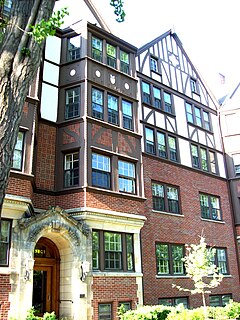
Buckeye–Shaker is a city planning area on the east side of Cleveland, Ohio. It encompasses two neighborhoods: in its south and west the old Buckeye neighborhood and in its northeast the Shaker Square neighborhood which is centered on an historic shopping district and an eponymous rapid transit station, located at the intersection of Shaker and Moreland Boulevards, on the light rail line that connects the city of Shaker Heights to downtown Cleveland. From the early to mid-20th century, the Buckeye Road neighborhood was known as Little Hungary, serving as the historic heart of Cleveland's Hungarian community, which at one time was the largest in the world outside of Hungary and for years has been almost completely African-American. Shaker Square, continues to be known as one of Cleveland's most notable neighborhoods, in terms of shopping, dining, architecture, education of its residents, participation in civic life, diversity and quality of living.

This is a list of properties and districts in Ohio that are listed on the National Register of Historic Places. There are over 4.000 in total. Of these, 73 are National Historic Landmarks. There are listings in each of Ohio's 88 counties.

Shaker Heights High School is a public high school located in Shaker Heights, Ohio, a suburb of Cleveland. The high school is the only public high school in the Shaker Heights City School District, which serves Shaker Heights and a small part of Cleveland. Shaker Heights High School is an International Baccalaureate World School, the only public high school in Cuyahoga County to hold this accreditation and offer rigorous IB classes. It is consistently ranked among the top districts in the state for National Merit semifinalists.

The Nature Center at Shaker Lakes is a nonprofit organization in Shaker Heights, Ohio that works to conserve a natural area, educate visitors about nature, and promote better environmental stewardship. It was founded in 1966 as the result of a volunteer effort to preserve the Shaker Parklands from becoming the route for a new freeway connecting Cleveland's East Side to downtown.

This is a list of the National Register of Historic Places listings in Cuyahoga County, Ohio.

Ambler Heights Historic District is a historic district in Cleveland Heights, Ohio, United States. Listed on the National Register of Historic Places in 2002, it includes 112 contributing buildings in an area of 73 acres (300,000 m2), which was created between 1903 and 1927.
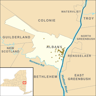
There are 69 properties listed on the National Register of Historic Places in Albany, New York, United States. Six are additionally designated as National Historic Landmarks (NHLs), the most of any city in the state after New York City. Another 14 are historic districts, for which 20 of the listings are also contributing properties. Two properties, both buildings, that had been listed in the past but have since been demolished have been delisted; one building that is also no longer extant remains listed.

The Weizer Building was a historic commercial building in the Buckeye-Shaker neighborhood of Cleveland, Ohio, United States. Constructed in 1913 in a heavily Hungarian immigrant community, it was named a historic site in the 1980s, but it is no longer standing.

The McClellan Heights Historic District is a 188.2-acre (76.2 ha) historic district in Davenport, Iowa, United States. It was listed on the National Register of Historic Places in 1984, at which time it included 354 buildings deemed to contribute to the historic character of the area.
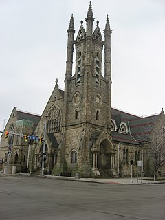
The former St. Paul's Episcopal Church is a historic church in Cleveland, Ohio, United States. Built for an Episcopal parish by a well-known architect, it became a prominent component of the city's wealthy Millionaire's Row, due to its grand architecture. Although vacated by its original owners in the 1920s, it was soon bought by a Catholic monastic group that occupies it into the present day. It was named a historic site in 1980.

Tower East is a high-rise office building in Shaker Heights, Ohio. At 160 feet (49 m), it is the tallest building in the city. Tower East was the last building in the United States designed by architect Walter Gropius. Gropius designed this building during his tenure with The Architect's Collaborative (TAC).

Rockefeller Park is a city park named in honor of oil magnate John D. Rockefeller Sr., located in Cleveland, Ohio. Part of the Cleveland Public Parks District, Rockefeller Park is immediately adjacent Wade Park to the southeast, and across Euclid Ave on its northwest border. Besides the distinction of being the largest park located completely within city limits, Rockefeller Park is a link in a chain of parkland that connects the heights region of the eastern suburbs to the city's lakefront. Following the path of Martin Luther King Jr. Drive and spanning a large section of Cleveland's East Sides, the park runs in a northwesterly path between suburban Shaker Heights, bisecting the University Circle neighborhood and terminating at Gordon Park on the city's lakefront, opened to the public in 1897. The park was dramatically expanded during the 1930s with labor provided by the Works Progress Administration. Landmarks found in Rockefeller Park include two separate entries on the National Register of Historic Places: one for its architecturally historic bridges, and one for its Cultural Gardens.

Wheeling Island Historic District is a national historic district located on Wheeling Island in Wheeling, Ohio County, West Virginia. The district includes 1,110 contributing buildings, 5 contributing sites, 2 contributing structures, and 3 contributing objects. It is a largely residential district consisting of two-story, frame detached dwellings built in the mid- to late-19th and early-20th century, including the Irwin-Brues House (1853) and a number of houses on Zane Street. The houses are representative of a number of popular architectural styles including Bungalow, Italianate, Queen Anne, and Colonial Revival. Notable non-residential contributing properties include the Exposition Building (1924), Thompson United Methodist Church (1913-1915), Madison School (1916), firehouse (1930-1931), the Bridgeport Bridge (1893), the Aetnaville Bridge (1891), "The Marina," Wheeling Island Baseball Park, and "Belle Island Park." It includes the separately listed Wheeling Suspension Bridge, Harry C. and Jessie F. Franzheim House, and John McLure House.

Hubbell & Benes was a prominent Cleveland, Ohio architectural firm formed by Benjamin Hubbell (1857–1935) and W. Dominick Benes (1867–1953) in 1897 after the pair departed from Coburn, Barnum, Benes & Hubbell. Their work included commercial and residential buildings as well as telephone exchange buildings, the West Side Market and Cleveland Museum of Art. Before teaming up they worked for Coburn and Barnum. Benes was Jeptha Wade’s personal architect and designed numerous public buildings, commercial buildings, and residences for him including the Wade Memorial Chapel.

Abram Garfield was the youngest son of President James A. Garfield and Lucretia Rudolph Garfield, and an architect who practiced in Cleveland, Ohio.
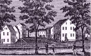
The Enfield Shakers Historic District encompasses some of the surviving remnants of a former Shaker community in Enfield, Connecticut. Founded in the 1780s, the Enfield Shaker community remained active until 1917. The surviving buildings of their once large community complexes are located in and around Taylor Road in northeastern Enfield, and were listed as a historic district on the National Register of Historic Places in 1979. The listing included 15 contributing buildings and one contributing site.
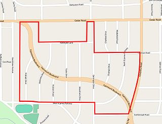
The Euclid Golf Allotment, also known as the Euclid Golf Historic District, is a historic district located in Cleveland Heights, Ohio, in the United States. Roughly bounded by Cedar Road, Coventry Road, West St. James Parkway, and Ardleigh Drive, the 142-acre (0.57 km2) site contains primarily residential homes built between 1913 and 1929. The historic district is built on land formerly owned by John D. Rockefeller and at one time leased to the Euclid Golf Club for its back nine holes, and it takes its name from this historic factoid. The Euclid Golf Allotment is a largely undisturbed example of an early 20th century planned community containing American Craftsman, Colonial Revival, French Renaissance Revival, Italian Renaissance Revival, Prairie School, Shingle Style, and Tudor Revival architecture.

Fairhill Road Village is a small housing development on the border of Cleveland and Cleveland Heights, Ohio.
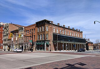
The South High Commercial Historic District is a historic district on High Street in Downtown Columbus, Ohio. The site was listed on the National Register of Historic Places in 1983 and the Columbus Register of Historic Properties in 1987.


