Dorchester is the county town of Dorset, England. It is situated between Poole and Bridport on the A35 trunk route. A historic market town, Dorchester is on the banks of the River Frome to the south of the Dorset Downs and north of the South Dorset Ridgeway that separates the area from Weymouth, 7 miles (11 km) to the south. The civil parish includes the experimental community of Poundbury and the suburb of Fordington.

Portesham, sometimes also spelled Portisham, is a village and civil parish in the county of Dorset in southwest England, situated in the Dorset Council administrative area approximately 6 miles (10 km) northwest of Weymouth, 6 miles (10 km) southwest of the county town Dorchester, and 2 miles (3 km) northeast of the Jurassic Coast World Heritage Site at Chesil Beach. The parish is quite large, covering several outlying hamlets and what were once their manors. In the 2011 census it had a population of 685 in 316 households and 342 dwellings.

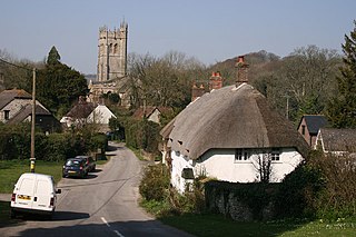
Milton Abbas is a village and civil parish in Dorset, England, lying around 5 miles southwest of Blandford Forum. In the 2011 Census the civil parish had a population of 755.

Iwerne Courtney, also known as Shroton, is a village and civil parish in the English county of Dorset. It lies approximately 4 miles north-west of Blandford Forum. It is sited by the small River Iwerne between Hambledon Hill to the south-west and the hills of Cranborne Chase to the east. In 2001 the parish had 187 households and a population of 400. In 2013 the estimated population of the parish was 410.

Puddletown is a village and civil parish in Dorset, England. It is situated by the River Piddle, from which it derives its name, about 4.5 miles (7 km) northeast of the county town Dorchester. Its earlier name Piddletown fell out of favour, probably because of connotations of the word "piddle". The name Puddletown was officially sanctioned in the late 1950s. Puddletown's civil parish covers 2,908 hectares and extends to the River Frome to the south. In 2013, the estimated population of the civil parish was 1450.

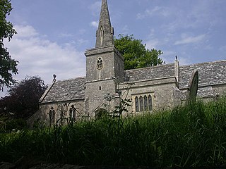
Cattistock is a village and civil parish in west Dorset, England, sited in the upper reaches of the Frome Valley, 8 miles (13 km) northwest of the county town Dorchester. The Dorset poet William Barnes called it "elbow-streeted Cattstock", a comment on the less-than-linear village street. In the 2011 census the parish had a population of 509.
Compton Valence is a small village and civil parish in the county of Dorset in southern England. It lies approximately 7 miles (11 km) west of the county town Dorchester. It is sited at the head of a narrow valley, formed by a small tributary of the River Frome, and is surrounded by the hills of the Dorset Downs, which has led to it having been described as "a pocket of habitation in the downs." Dorset County Council estimate that in 2013 the population of the parish was 50.

Dewlish is a village and civil parish in the county of Dorset in southern England, and is situated approximately 7 miles (11 km) north-east of the county town Dorchester. The village is sited in the valley of the small Devil's Brook among the chalk hills of the Dorset Downs; the parish covers about 2,100 acres (850 ha) and extends west to include part of the valley of the small Cheselbourne stream, and east to include a dry valley at Dennet's Bottom. The surrounding area is part of the Dorset Area of Outstanding Natural Beauty (AONB). In the 2011 census the parish had a population of 284.

Melbury Bubb is a small village and civil parish in the county of Dorset in South West England, situated approximately 7 miles (11 km) south of the town of Sherborne. It is sited on Cornbrash limestone beneath the chalk hills of the Dorset Downs. The A37 trunk road between Dorchester and Bristol passes about 0.5 miles (0.80 km) to the west, on the other side of Bubb Down Hill. This hill used to be the site of a beacon. The first half of the village name derives from maele and burh—Old English for "multi-coloured" and "fortified place"—and the second half is a manorial name which derives either from a Saxon resident named 'Bubba' or from medieval lords of the manor. Dorset County Council's latest (2013) estimate of the parish population is 40.
Piddletrenthide is a village and civil parish in the English county of Dorset. It is sited by the small River Piddle in a valley on the dip slope of the Dorset Downs, 8 miles (13 km) north of Dorchester. In the 2011 census the parish—which includes the small village of Plush to the northeast—had 323 dwellings, 290 households and a population of 647.

Rampisham is a village and civil parish in the county of Dorset in southern England, situated approximately 11 miles (18 km) northwest of the county town Dorchester. The village is sited on greensand in a valley surrounded by the chalk hills of the Dorset Downs. The parish includes the hamlet of Uphall northwest of the main village.

Winterborne Whitechurch is a village and civil parish in central Dorset, England, situated in a winterbourne valley on the A354 road on the Dorset Downs five miles southwest of Blandford Forum. In the 2011 census the civil parish had 354 dwellings, 331 households and a population of 757.

Winterbourne Abbas is a village and civil parish in south west Dorset, England, situated in a valley on the A35 road 5 miles (8.0 km) west of Dorchester. In the 2011 census the parish had a population of 355.
Littlebredy is a small village and civil parish in the English county of Dorset, situated approximately 6.5 miles (10.5 km) west of the county town Dorchester. It is sited at the head of the valley of the small River Bride, surrounded by wooded chalk hills of the Dorset Downs. The parish contains the Valley of Stones National Nature Reserve and is in an area rich with evidence of early human occupation. In the 2011 census it had a population of 121.

Upwey is a suburb of Weymouth in south Dorset, England. The suburb is situated on the B3159 road in the Wey valley. The area was formerly a village until it was absorbed into the Weymouth built-up area. It is located four miles north of the town centre in the outer suburbs. In the Census 2001 the combined population of Upwey and neighbouring Broadwey was 4,349.

Martin is a village and civil parish in the New Forest district of Hampshire, England. The nearest town, Fordingbridge, is 7 miles (11 km) to the south-east, and the cathedral city of Salisbury is 12 miles (19 km) to the north-east.

Emmington is a village in the civil parish of Chinnor, in the South Oxfordshire district, in the county of Oxfordshire, England. It is about 4.5 miles (7 km) southeast of Thame. In 1931 the parish had a population of 41. On 1 April 1932 the parish was abolished and merged with Chinnor.

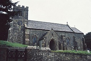
Pitney is a village and parish in Somerset, England, located 2.5 miles (4.0 km) east of Langport and 3 miles (4.8 km) west of Somerton in the South Somerset district. In 2011, the village had a population of 374.

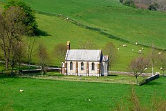
Poxwell is a hamlet and civil parish in the county of Dorset in southwest England. It is located 6 miles (9.7 km) east of Weymouth. The current population of the parish is around 50.

Stanton St. John is a village and civil parish in Oxfordshire, England, about 4.5 miles (7 km) northeast of the centre of Oxford. The village is 330 feet (100 m) above sea level on the eastern brow of a group of hills northeast of Oxford, in a slight saddle between two of the hills.