Alsip, Illinois

Last updated
Alsip
Village
Village of Alsip, Illinois
AlsipVillageHall.png
Alsip Village Hall
Flag of Alsip, Illinois.svg
Alsip Illinois Seal.png
Cook County Illinois Incorporated and Unincorporated areas Alsip Highlighted.svg
Location of Alsip in Cook County, Illinois.
Illinois in United States (US48).svg
Location of Illinois in the United States
Chicago locator map.png
Red pog.svg
Alsip
Location in Illinois
USA Illinois location map.svg
Red pog.svg
Alsip
Alsip (Illinois)
Usa edcp location map.svg
Red pog.svg
Alsip
Alsip (the United States)
North America laea location map.svg
Red pog.svg
Alsip
Alsip (North America)
Coordinates: 41°40′14″N87°43′56″W / 41.67056°N 87.73222°W / 41.67056; -87.73222
Country Flag of the United States.svg  United States
State Illinois
County Cook
Township Worth
Incorporated 1840
Government
  Type Mayor–council
   Mayor John D. Ryan
Area
[1]
  Total6.63 sq mi (17.16 km2)
  Land6.53 sq mi (16.90 km2)
  Water0.10 sq mi (0.26 km2)  1.54%
Population
 (2020)
  Total19,063
  Density2,921.53/sq mi (1,127.97/km2)
Standard of living (2007-11)
   Per capita income $25,286
   Median home value $202,100
ZIP code(s)
60803
Area code(s) 708/464
Geocode 01010
FIPS code 17-01010
Website villageofalsip.org

Alsip is a village in Cook County, Illinois, United States. The population was 19,063 at the 2020 census. [2] It is part of the Chicago metropolitan area.

Contents

Alsip was settled in the 1830s by German and Dutch farmers. The village is named after Frank Alsip, the owner of a brickyard that opened there in 1885. [3] The village began to grow after the Tri-State Tollway was built there in 1959.

Geography

This is one of the two water towers which are notable landmarks with their dark red color and fluted shaft. Both are visible to travelers on I-294. AlsipWaterTower.png
This is one of the two water towers which are notable landmarks with their dark red color and fluted shaft. Both are visible to travelers on I-294.

Alsip is located at 41°40′14″N87°43′56″W / 41.67056°N 87.73222°W / 41.67056; -87.73222 (41.670433, -87.732199). [4]

According to the 2021 census gazetteer files, Alsip has a total area of 6.63 square miles (17.17 km2), of which 6.53 square miles (16.91 km2) (or 98.49%) is land and 0.10 square miles (0.26 km2) (or 1.51%) is water. [5]

Alsip is bordered to the west by the villages of Worth and Palos Heights. To the south is Crestwood. Oak Lawn lies to the north. Merrionette Park, Blue Island, and Robbins lie to the east (north-south, respectively). The Mount Greenwood neighborhood of Chicago lies to the north and east. [6]

Most of the town lies to the north of the Cal-Sag Channel. However, Chippewa Ridge subdivision, which was built upon the former Alsip Nursery, lies southwest of the Cal-Sag. In conjunction with the Illinois Department of Natural Resources and the Water Reclamation District of Chicago, the village operates a boat launch on the canal, permitting inland access to Lake Michigan. [7]

The Alsip area is home to two predominantly African-American cemeteries, Burr Oak and Restvale cemeteries, which are the resting places of many Chicago blues musicians (including Muddy Waters, Willie Dixon and Dinah Washington), athletes (Jimmie Crutchfield), and other celebrities. Emmett Till, whose murder in Mississippi at age 14 in 1955 was an important moment in the Civil Rights Movement, is buried at Burr Oak. In 2004, that cemetery was covered in the national media when the murder investigation was re-opened, and Till's body was exhumed. [8]

Six years later, on July 9, 2010, Cook County Sheriff Tom Dart alleged that four workers at Burr Oak cemetery dug up more than 200 graves, dumped the bodies into unmarked mass graves, and resold the plots to unsuspecting members of the public. The three men and one woman were charged and convicted with one count each of dismembering a human body. [9]

Demographics

Historical population
CensusPop.Note
1930 327
1940 54165.4%
1950 1,228127.0%
1960 3,770207.0%
1970 11,608207.9%
1980 17,13447.6%
1990 18,2276.4%
2000 19,7258.2%
2010 19,277−2.3%
2020 19,063−1.1%
U.S. Decennial Census [10]
2010 [11] 2020 [12]

As of the 2020 census [13] there were 19,063 people, 7,796 households, and 4,455 families residing in the village. The population density was 2,877.43 inhabitants per square mile (1,110.98/km2). There were 8,016 housing units at an average density of 1,209.96 per square mile (467.17/km2). The racial makeup of the village was 51.58% White, 22.48% African American, 1.95% Asian, 0.70% Native American, 0.06% Pacific Islander, 12.20% from other races, and 11.05% from two or more races. Hispanic or Latino residents of any race were 26.52% of the population.

The top five non-African American, non-Hispanic ancestries reported in Alsip as of the 2000 census were Irish (17.1%), German (14.0%), Polish (9.7%), Italian (4.8%) and English (3.5%).

There were 7,796 households, out of which 28.7% had children under the age of 18 living with them, 40.60% were married couples living together, 13.94% had a female householder with no husband present, and 42.86% were non-families. 38.13% of all households were made up of individuals, and 20.23% had someone living alone who was 65 years of age or older. The average household size was 3.27 and the average family size was 2.41.

The village's age distribution consisted of 23.5% under the age of 18, 8.3% from 18 to 24, 26.3% from 25 to 44, 22.7% from 45 to 64, and 19.4% who were 65 years of age or older. The median age was 39.0 years. For every 100 females, there were 90.9 males. For every 100 females age 18 and over, there were 85.3 males.

The median income for a household in the village was $58,768, and the median income for a family was $72,444. Males had a median income of $48,254 versus $36,313 for females. The per capita income for the village was $30,308. About 7.7% of families and 7.7% of the population were below the poverty line, including 4.0% of those under age 18 and 11.3% of those age 65 or over.

The municipal logo for the Village of Alsip; it denotes the importance of industry and education, as well as transportation and community unity. AlsipLogo.png
The municipal logo for the Village of Alsip; it denotes the importance of industry and education, as well as transportation and community unity.
Alsip village, Illinois - Demographic Profile
(NH = Non-Hispanic)
Race / EthnicityPop 2010 [11] Pop 2020 [12] % 2010% 2020
White alone (NH)11,2728,89558.47%46.66%
Black or African American alone (NH)3,4514,23517.90%22.22%
Native American or Alaska Native alone (NH)1880.09%0.04%
Asian alone (NH)4343592.25%1.88%
Pacific Islander alone (NH)580.03%0.04%
Some Other Race alone (NH)26500.13%0.26%
Mixed Race/Multi-Racial (NH)2294521.19%2.37%
Hispanic or Latino (any race)3,8425,05619.93%26.52%
Total19,27719,063100.00%100.00%

Note: the US Census treats Hispanic/Latino as an ethnic category. This table excludes Latinos from the racial categories and assigns them to a separate category. Hispanics/Latinos can be of any race.

Government

Most of Alsip is in Illinois's 1st congressional district; the portion north of 115th Street, and the city block northeast of 119th Street and Lawndale Avenue, are in the 3rd district.

Policy-making and legislative authority are vested in the governing Village Board consisting of the Village President, often referred to as the Mayor, and six Trustees, and a Village Clerk. The Village Clerk is an ex officio member of the Board and does not vote. All Board members are elected at large. All Board members serve four-year terms, with the Village President, the Village Clerk, and three Trustees elected usually on the first Tuesday in April following Presidential election year, while the other three Trustees are usually elected on the first Tuesday in April two years later. Beginning with those elected in the April 4, 2017 election, no person may hold the office of Village President, Village Clerk, or Village Trustee for more than three consecutive four-year terms.

The current Village government, as of May 2019 (with the year their term ends):

Each trustee and the mayor serve on one or more committees or commissions which oversee government functions. The individual assignments are available at the village website.

There are also a finance director who helps guide the government on fiduciary matters and a law firm that serves as the village attorneys to guide the government on legal matters. [14]

Mayors

Education

The public library district combines the municipalities of Alsip and neighboring Merrionette Park, though the library is located in Alsip on Pulaski Road. AlsipPublicLibrary.png
The public library district combines the municipalities of Alsip and neighboring Merrionette Park, though the library is located in Alsip on Pulaski Road.
Elementary school districts
Secondary School District
Community college
Private schools

Business and industry

Alsip is home to the international headquarters of Griffith Laboratories. [20]

One of the two Chicago area Coca-Cola bottling plants is located in Alsip.

Alsip is home to Alsip MiniMill, a producer of corrugating medium using Old Corrugated Containers (OCC) as the primary raw material.

Related Research Articles

<span class="mw-page-title-main">Barrington Hills, Illinois</span> Village in Illinois, United States

Barrington Hills is a village located about 40 miles (64 km) northwest of Chicago in the U.S. state of Illinois. Per the 2020 census, the population was 4,114. It straddles approximately 29 square miles (75 km2) over four counties, Cook, Kane, Lake, and McHenry. The Village of Barrington Hills was incorporated in 1957.

<span class="mw-page-title-main">Bridgeview, Illinois</span> Village in Illinois, United States

Bridgeview is a village in Cook County, Illinois, United States. It is located approximately 15 miles (24 km) southwest of the Chicago Loop. As of the 2020 census, the village population was 17,027.

<span class="mw-page-title-main">Broadview, Illinois</span> Village in Illinois, United States

Broadview is a village in Cook County, Illinois, 12 miles (19 km) west of downtown Chicago. As of the 2020 census it had a population of 7,998.

<span class="mw-page-title-main">Burr Ridge, Illinois</span> Village in Illinois, United States

Burr Ridge is a village in Cook and DuPage counties in the U.S. state of Illinois. Per the 2020 census, the population was 11,192.

<span class="mw-page-title-main">Chicago Ridge, Illinois</span> Village in Illinois, United States

Chicago Ridge is a village in Cook County, Illinois, United States. Per the 2020 census, the population was 14,433.

<span class="mw-page-title-main">Countryside, Illinois</span> City in Illinois, United States

Countryside is a city in Cook County, Illinois, United States. Per the 2020 census, the population was 6,420.

<span class="mw-page-title-main">Hazel Crest, Illinois</span> Village in Illinois, United States

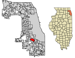
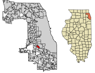
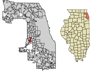
Hazel Crest is a village in Cook County, Illinois, United States. The population was 13,382 at the 2020 census.

<span class="mw-page-title-main">Hillside, Illinois</span> Village in Illinois, United States

Hillside is a village in Cook County, Illinois, United States. As of the 2020 census it had a population of 8,320.

<span class="mw-page-title-main">Hometown, Illinois</span> City in Cook County, Illinois, US

Hometown is a city in Cook County, Illinois, United States. The population was 4,343 at the 2020 census.

<span class="mw-page-title-main">Homewood, Illinois</span> Village in Illinois, United States

Homewood is a village in Cook County, Illinois, United States. The population was 19,463 at the 2020 census.

<span class="mw-page-title-main">Lansing, Illinois</span> Village in Illinois, United States

Lansing is a village in Cook County, Illinois, United States. Lansing is a south suburb of Chicago. The population was 29,076 at the 2020 census.

<span class="mw-page-title-main">Oak Lawn, Illinois</span> Village in Illinois, United States

Oak Lawn is a village in Cook County, Illinois, United States. The population was 58,362 at the 2020 census. Oak Lawn is a suburb of Chicago, located southwest of the city. It shares borders with the city in two areas but is surrounded mostly by other suburbs.

<span class="mw-page-title-main">Worth, Illinois</span> Village in Illinois, United States

Worth is a village in Cook County, Illinois, United States, a suburb of Chicago. Per the 2020 census, the population was 10,970.

<span class="mw-page-title-main">Bolingbrook, Illinois</span> Village in Illinois, United States

Bolingbrook is a village in Will and DuPage counties in the U.S. state of Illinois. It is a southwest suburb of Chicago on I-55 and Historic Route 66. The village was a new town built on the Gateway Wetlands west of the Des Plaines River in the 1960s. Bolingbrook experienced rapid growth in the 1980s and 1990s, and eventually became the second largest town in the county after Joliet. Per the 2020 census, the population was 73,922. As of 2010, it is the 17th largest incorporated place in Illinois and the state's 2nd largest village.

<span class="mw-page-title-main">Carol Stream, Illinois</span> Village in Illinois, United States

Carol Stream is a village in DuPage County, Illinois, United States, and a suburb of Chicago. Carol Stream was incorporated on January 5, 1959, and named after its founder's daughter. Per the 2020 census, the population was 39,854.

<span class="mw-page-title-main">Bannockburn, Illinois</span> Village in Illinois, United States

Bannockburn is a village in West Deerfield and Vernon townships in Lake County, Illinois, United States. Per the 2020 census, the population was 1,013. The village is generally considered part of the Chicago area's North Shore region. The Friedman house by Frank Lloyd Wright is located in Bannockburn.

<span class="mw-page-title-main">Lake Villa, Illinois</span> Village in Illinois, United States

Lake Villa is a village in Lake County, Illinois United States. Per the 2020 census, the population was 8,741. Lake Villa lies within Lake Villa Township and about 50 miles north of Chicago and is part of the United States Census Bureau's Chicago combined statistical area (CSA).

<span class="mw-page-title-main">Worth Township, Cook County, Illinois</span> Township in Illinois, United States

Worth Township is one of 29 townships in Cook County, Illinois. As of the 2020 census, its population was 152,934, with its most populous municipalities including Oak Lawn, Evergreen Park (19,943), Alsip, and Chicago Ridge. It was founded in 1849, when the county voted to subdivide itself into townships.

<span class="mw-page-title-main">Lyons Township, Cook County, Illinois</span> Township in Illinois, United States

Lyons Township is one of 29 townships in Cook County, Illinois. As of the 2020 census, its population was 115,105, with its most populous municipalities including La Grange, Justice and Summit. Lyons Township was established in 1850. The village of Lyons, almost all of which lies within the township, is often confused with it.

<span class="mw-page-title-main">Downers Grove Township, DuPage County, Illinois</span> Township in Illinois, United States

Downers Grove Township is one of nine townships in DuPage County, Illinois, USA. As of the 2020 census, its population was 149,921 and it contained 61,933 housing units. It is the largest township in the county, both in terms of area and population.

References

  1. "2020 U.S. Gazetteer Files". United States Census Bureau. Retrieved March 15, 2022.
  2. "Alsip village, Illinois". United States Census Bureau . Retrieved February 23, 2021.
  3. Callary, Edward (29 September 2008). Place Names of Illinois. University of Illinois Press. p. 7. ISBN   978-0-252-09070-7.
  4. "US Gazetteer files: 2010, 2000, and 1990". United States Census Bureau. 2011-02-12. Retrieved 2011-04-23.
  5. Bureau, US Census. "Gazetteer Files". Census.gov. Retrieved 2022-06-29.
  6. "Google Maps". Google Maps. Retrieved 2014-06-13.
  7. "Boat Launch". www.alsip.org.il. Archived from the original on 7 May 2008. Retrieved 17 January 2022.
  8. "Body of '55 civil rights victim returned to grave". Associated Press. 2005-06-04. Retrieved 2007-08-24.
  9. "Remains from Burr Oak Cemetery scandal reburied - Gary/Chicago Crusader". Chicagocrusader.com. 19 May 2016. Retrieved 25 January 2019.
  10. "Decennial Census of Population and Housing by Decades". US Census Bureau.
  11. 1 2 "P2 HISPANIC OR LATINO, AND NOT HISPANIC OR LATINO BY RACE - 2010: DEC Redistricting Data (PL 94-171) - Alsip village, Illinois". United States Census Bureau .
  12. 1 2 "P2 HISPANIC OR LATINO, AND NOT HISPANIC OR LATINO BY RACE - 2020: DEC Redistricting Data (PL 94-171) - Alsip village, Illinois". United States Census Bureau .
  13. "Explore Census Data". data.census.gov. Retrieved 2022-06-28.
  14. "Village Of Alsip". Village Of Alsip. Archived from the original on 2013-12-07. Retrieved 2014-06-13.
  15. "District 126 Alsip, Hazelgreen, Oak Lawn ::". Dist126.k12.il.us. Archived from the original on 2012-03-03. Retrieved 2014-06-13.
  16. "Hamlin Upper Grade Center - HAMLIN UPPER GRADE CENTER". Ahsd125.org. 2014-05-13. Archived from the original on 2014-08-28. Retrieved 2014-06-13.
  17. "Archived copy". Archived from the original on 2015-10-05. Retrieved 2015-10-04.{{cite web}}: CS1 maint: archived copy as title (link)
  18. "Community High School District 218 - Index". Chsd218.org. 2014-06-03. Retrieved 2014-06-13.
  19. "Moraine Valley Community College". Morainevalley.edu. 2011-10-04. Retrieved 2014-06-13.
  20. "Griffith Foods". Griffithfoods.com. Retrieved 25 January 2019.