Ramblewood East, Coral Springs, Florida

Last updated
Ramblewood East, Florida
USA Florida location map.svg
Red pog.svg
Ramblewood East, Florida
Usa edcp location map.svg
Red pog.svg
Ramblewood East, Florida
Coordinates: 26°16′50″N80°14′42″W / 26.28056°N 80.24500°W / 26.28056; -80.24500 Coordinates: 26°16′50″N80°14′42″W / 26.28056°N 80.24500°W / 26.28056; -80.24500
Country Flag of the United States.svg  United States
State Flag of Florida.svg  Florida
County   Broward
Area
  Total0.1 sq mi (0.2 km2)
  Land0.1 sq mi (0.2 km2)
  Water0.0 sq mi (0.0 km2)
Population
 (2000)
  Total1,395
  Density14,932.7/sq mi (5,765.5/km2)
Time zone UTC-5 (Eastern (EST))
  Summer (DST) UTC-4 (EDT)
FIPS code 12-59512 [1]

Ramblewood East is a former census-designated place (CDP) in Broward County, Florida, United States. The population was 1,395 at the 2000 census. It is now incorporated as a community of Coral Springs, Florida.

Contents

Geography

Ramblewood East is located at 26°16′50″N80°14′42″W / 26.28056°N 80.24500°W / 26.28056; -80.24500 (26.280508, -80.244959). [2]

According to the United States Census Bureau, the CDP has a total area of 0.2 km2 (0.1 mi2), all land.

Demographics

As of the census [1] of 2000, there were 1,395 people, 812 households, and 349 families residing in the CDP. The population density was 5,984.6/km2 (14,932.7/mi2). There were 929 housing units at an average density of 3,985.4/km2 (9,944.4/mi2). The racial makeup of the CDP was 87.60% White (72.7% were Non-Hispanic White,) [3] 4.59% African American, 0.14% Native American, 1.86% Asian, 0.07% Pacific Islander, 3.58% from other races, and 2.15% from two or more races. Hispanic or Latino of any race were 19.71% of the population.

There were 812 households, out of which 14.0% had children under the age of 18 living with them, 28.4% were married couples living together, 10.8% had a female householder with no husband present, and 57.0% were non-families. 52.7% of all households were made up of individuals, and 32.5% had someone living alone who was 65 years of age or older. The average household size was 1.72 and the average family size was 2.48.

In the CDP, the population was spread out, with 13.4% under the age of 18, 7.0% from 18 to 24, 25.9% from 25 to 44, 13.5% from 45 to 64, and 40.2% who were 65 years of age or older. The median age was 50 years. For every 100 females, there were 69.7 males. For every 100 females age 18 and over, there were 66.2 males.

The median income for a household in the CDP was $23,407, and the median income for a family was $26,454. Males had a median income of $26,875 versus $24,352 for females. The per capita income for the CDP was $20,266. About 11.3% of families and 14.4% of the population were below the poverty line, including 9.7% of those under age 18 and 12.5% of those age 65 or over.

As of 2000, English as a first language accounted for 69.91% of all residents, while Spanish made up 26.99%, and Yiddish was the mother tongue of 3.09% of the population. [4]

Related Research Articles

East Richmond Heights, California Census-designated place in California, United States

East Richmond Heights is an unincorporated community and census-designated place (CDP) in western Contra Costa County, California, United States. Its population was 3,280 at the 2010 census.

West Simsbury, Connecticut Census-designated place in Connecticut, United States

West Simsbury is a census-designated place (CDP) and section of the town of Simsbury in Hartford County, Connecticut, United States. The population of the CDP was 2,447 at the 2010 census.

Plainfield Village, Connecticut Village in Connecticut, United States

Plainfield Village is a village and census-designated place (CDP) in the town of Plainfield, Connecticut in the United States. The population was 2,557 at the 2010 census. It is located in the southwest part of town, in the area west of I-395 and south of Route 14. The village is also the core of the Plainfield, CT urban cluster.

Nobleton, Florida Census-designated place in Florida, United States

Nobleton is an unincorporated community and census-designated place (CDP) in Hernando County, Florida, United States. The population was 282 at the 2010 census, up from 160 at the 2000 census.

Florida Ridge, Florida CDP in Florida, United States

Florida Ridge is a census-designated place (CDP) in Indian River County, Florida, United States. The population was 18,164 at the 2010 census.

South Beach, Florida Census-designated place in Florida, United States

South Beach is a census-designated place (CDP) on North Hutchinson Island in Indian River County, Florida, United States. The population was 3,501 at the 2010 census. It is ranked tenth in Florida locations by per capita income as of 2010.

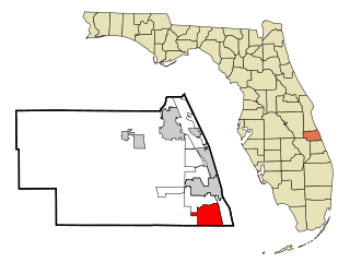
Juno Ridge is a census-designated place (CDP) in Palm Beach County, Florida, United States. The population was 742 at the 2000 census.

Buckner, Kentucky CDP in Kentucky, United States

Buckner is a census-designated place (CDP) in Oldham County, Kentucky, United States. The population was 4,000 at the 2000 census.

Riverside, Harford County, Maryland Census-designated place in Maryland, United States

Riverside is a census-designated place (CDP) in Harford County, Maryland, United States. The population was 6,425 at the 2010 census. The term "Riverside" is generally used interchangeably with "Belcamp"; both names are accepted for the U.S. Postal Service's ZIP Code of 21017. However, the original community of Belcamp is located south of U.S. Route 40, outside the Riverside CDP.

Yarmouth Port, Massachusetts Census-designated place in Massachusetts, United States

Yarmouth Port is a census-designated place (CDP) in the town of Yarmouth in Barnstable County, Massachusetts, United States. The population was 5,320 at the 2010 census.

Ramblewood, New Jersey Census-designated place in New Jersey, United States

Ramblewood is an unincorporated community and census-designated place (CDP) located within Mount Laurel Township in Burlington County, New Jersey, United States. As of the 2010 United States Census, the CDP's population was 5,907.

Leavittsburg, Ohio CDP in Ohio, United States

Leavittsburg is a census-designated place (CDP) in Trumbull County, Ohio, United States. The population was 2,200 at the 2000 census. It is part of the Youngstown–Warren–Boardman, OH-PA Metropolitan Statistical Area.

Atlantic, Pennsylvania Census-designated place in Pennsylvania, United States

Atlantic is a census-designated place (CDP) in Crawford County, Pennsylvania, United States. The population was 77 at the 2010 census, up from 43 in 2000.

Fredericksburg, Crawford County, Pennsylvania Census-designated place in Pennsylvania, United States

Fredericksburg is a census-designated place (CDP) in Crawford County, Pennsylvania, United States. The population was 733 at the 2010 census, down from 1,140 in 2000, when the CDP included the area that is now listed as Kerrtown.

Evansburg, Pennsylvania Census-designated place in Pennsylvania, United States

Evansburg is a census-designated place (CDP) in Montgomery County, Pennsylvania, United States. The population was 2,129 at the 2010 census. It is a section of Lower Providence Township and is the namesake of Evansburg State Park.

South Sumter, South Carolina CDP in South Carolina, United States

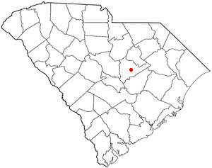
South Sumter is a census-designated place (CDP) in Sumter County, South Carolina, United States. The population was 3,365 at the 2000 census. It is included in the Sumter, South Carolina Metropolitan Statistical Area.

Laureles, Texas CDP in Texas, United States

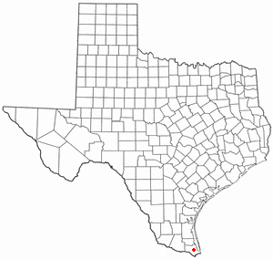
Laureles is a census-designated place (CDP) in Cameron County, Texas, United States. The population was 3,692 at the 2010 census. It is part of the Brownsville–Harlingen Metropolitan Statistical Area. Laureles is an area between Los Fresnos and San Benito, Texas.

Lincolnia, Virginia Census-designated place in Virginia, United States

Lincolnia is a census-designated place (CDP) in Fairfax County, Virginia, United States. The population was 22,828 at the 2010 census, an increase of over 44% from 2000.

Prosperity, West Virginia Census-designated place in West Virginia, United States

Prosperity is a census-designated place (CDP) in Raleigh County, West Virginia, United States. The population was 1,498 at the 2010 census.

Westerly (CDP), Rhode Island CDP in Rhode Island, United States

Westerly is a census-designated place (CDP) in the town of Westerly in Washington County, Rhode Island, United States. The population was 17,682 at the 2000 census.

References

  1. 1 2 "U.S. Census website". United States Census Bureau . Retrieved 2008-01-31.
  2. "US Gazetteer files: 2010, 2000, and 1990". United States Census Bureau. 2011-02-12. Retrieved 2011-04-23.
  3. "Demographics of Ramblewood East, FL". MuniNetGuide.com. Retrieved 2007-11-17.
  4. "MLA Data Center Results for Ramblewood East, FL". Modern Language Association . Retrieved 2007-11-17.