Smithton Township, St. Clair County, Illinois

Last updated
Smithton Township
Township
Map highlighting Smithton Township, St. Clair County, Illinois.svg
Location in St. Clair County
Map of Illinois highlighting St. Clair County.svg
St. Clair County's location in Illinois
Country Flag of the United States.svg  United States
State Flag of Illinois.svg  Illinois
County Flag of St. Clair County, Illinois.svg St. Clair
EstablishedNovember 6, 1883
Area
  Total32.91 sq mi (85.2 km2)
  Land32.28 sq mi (83.6 km2)
  Water0.63 sq mi (1.6 km2)  1.91%
Population
 (2010)
  Estimate 
(2016) [1]
4,225
  Density132.4/sq mi (51.1/km2)
Time zone UTC-6 (CST)
  Summer (DST) UTC-5 (CDT)
FIPS code 17-163-70265

Smithton Township (Township 1 South, Range 8 West) is located in St. Clair County, Illinois. As of the 2010 census, its population was 4,275 and it contained 1,684 housing units. [2]

Contents

Geography

According to the 2010 census, the township has a total area of 32.91 square miles (85.2 km2), of which 32.28 square miles (83.6 km2) (or 98.09%) is land and 0.63 square miles (1.6 km2) (or 1.91%) is water. [2]

Demographics

Historical population
CensusPop.Note
2016 (est.)4,225 [1]
U.S. Decennial Census [3]

Elected Officials

The current Members of the Smithton Township Board are Supervisor William F. Weber; Trustees Donald Barkau, Mark Rodriguez, Neil Espenschied, Quentin Grommet; Highway Commissioner Paul Reinneck; Clerk Troy L. Herring.

All seven Smithton Township Officials are serving a four-year term that ends in May, 2025.

Related Research Articles

<span class="mw-page-title-main">St. Clair County, Illinois</span> County in Illinois, United States

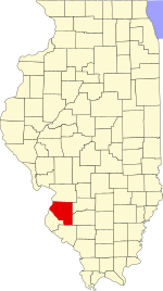
St. Clair County is the ninth most populous county in Illinois, located in the southwestern part of the state along the Mississippi River bordering Missouri. Located directly east of St. Louis, the county is part of the Metro East region of the Greater St. Louis metropolitan area. As of the 2020 United States census, St. Clair County had a population of 257,400, making it the third most populous county in Illinois outside the Chicago metropolitan area. Belleville is the county’s seat and largest city.

<span class="mw-page-title-main">Smithton, Illinois</span> Village in Illinois, United States

Smithton is a village in St. Clair County, Illinois, United States. The population was 4,006 in the 2020 United States Census. It is part of the Metro East region of Greater Saint Louis.

<span class="mw-page-title-main">Canteen Township, St. Clair County, Illinois</span> Township in Illinois, United States

Canteen Township is located in St. Clair County, Illinois. As of the 2010 census, its population was 10,263 and it contained 4,027 housing units. Canteen Township was formed from Centreville Station Township when it was subdivided on March 5, 1910.

<span class="mw-page-title-main">Caseyville Township, St. Clair County, Illinois</span> Township in Illinois, United States

Caseyville Township is located in St. Clair County, Illinois, United States. As of the 2010 census, its population was 31,996 and it contained 14,054 housing units.

<span class="mw-page-title-main">Centreville Township, St. Clair County, Illinois</span> Township in Illinois, United States

Centreville Township is located in St. Clair County, Illinois. As of the 2010 census, its population was 25,386 and it contained 10,535 housing units. Centreville Township was formed from Centreville Station when it was subdivided on March 5, 1910.

<span class="mw-page-title-main">Engelmann Township, St. Clair County, Illinois</span> Township in Illinois, United States

Engelmann Township is located in St. Clair County, Illinois. As of the 2010 census, its population was 726 and it contained 288 housing units.

<span class="mw-page-title-main">Fayetteville Township, St. Clair County, Illinois</span> Township in Illinois, United States

Fayetteville Township is located in St. Clair County, Illinois. As of the 2010 census, its population was 1,668 and it contained 722 housing units.

<span class="mw-page-title-main">Freeburg Township, St. Clair County, Illinois</span> Township in Illinois, United States

Freeburg Township is located in St. Clair County, Illinois. As of the 2010 census, its population was 5,109 and it contained 2,118 housing units.

<span class="mw-page-title-main">Lebanon Township, St. Clair County, Illinois</span> Township in Illinois, United States

Lebanon Township is located in St. Clair County, Illinois. As of the 2010 census, its population was 4,538 and it contained 2,005 housing units.

<span class="mw-page-title-main">Lenzburg Township, St. Clair County, Illinois</span> Township in Illinois, United States

Lenzburg Township is located in St. Clair County, Illinois. As of the 2010 census, its population was 1,047 and it contained 450 housing units.

<span class="mw-page-title-main">Marissa Township, St. Clair County, Illinois</span> Township in Illinois, United States

Marissa Township is located in St. Clair County, Illinois. As of the 2010 census, its population was 2,468 and it contained 1,175 housing units.

<span class="mw-page-title-main">Mascoutah Township, St. Clair County, Illinois</span> Township in Illinois, United States

Mascoutah Township is located in St. Clair County, Illinois. As of the 2010 census, its population was 8,217 and it contained 3,335 housing units.

<span class="mw-page-title-main">Millstadt Township, St. Clair County, Illinois</span> Township in Illinois, United States

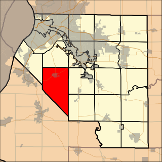
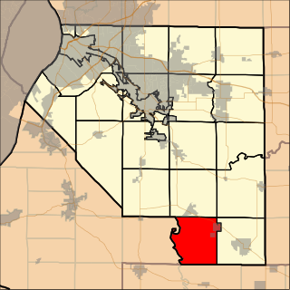
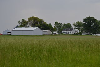
Millstadt Township is located in St. Clair County, Illinois. As of the 2010 census, its population was 6,718 and it contained 2,782 housing units.

<span class="mw-page-title-main">New Athens Township, St. Clair County, Illinois</span> Township in Illinois, United States

New Athens Township is located in St. Clair County, Illinois. As of the 2010 census, its population was 2,657 and it contained 1,129 housing units.

<span class="mw-page-title-main">O'Fallon Township, St. Clair County, Illinois</span> Township in Illinois, United States

O'Fallon Township is located in St. Clair County, Illinois. As of the 2010 census, its population was 26,053 and it contained 10,338 housing units.

<span class="mw-page-title-main">Shiloh Valley Township, St. Clair County, Illinois</span> Township in Illinois, United States

Shiloh Valley Township is located in St. Clair County, Illinois. As of the 2010 census, its population was 11,631 and it contained 4,284 housing units. Shiloh Valley Township was originally called Shiloh before its name was changed on an unknown date.

<span class="mw-page-title-main">St. Clair Township, St. Clair County, Illinois</span> Township in Illinois, United States

St. Clair Township is located in St. Clair County, Illinois. As of the 2010 census, its population was 35,498 and it contained 15,366 housing units. St. Clair Township formed from a portion of Belleville Township on October 5, 1885.

<span class="mw-page-title-main">Stites Township, St. Clair County, Illinois</span> Township in Illinois, United States

Stites Township is located in St. Clair County, Illinois. As of the 2010 census, its population was 749 and it contained 326 housing units. Stites Township was originally named Brooklyn Township when it was reorganized from a portion of East St. Louis Township in February, 1888. Its name was changed to Stites in April, 1888.

<span class="mw-page-title-main">Kansas Township, Woodford County, Illinois</span> Township in Illinois, United States

Kansas Township is located in Woodford County, Illinois. As of the 2010 census, its population was 433 and it contained 172 housing units. Kansas Township formed from Palestine Township in September, 1859.

<span class="mw-page-title-main">Dale Township, McLean County, Illinois</span> Township in Illinois, United States

Dale Township is located in McLean County, Illinois. As of the 2010 census, its population was 1,233 and it contained 521 housing units.

References

  1. 1 2 "Population and Housing Unit Estimates" . Retrieved June 9, 2017.
  2. 1 2 "Population, Housing Units, Area, and Density: 2010 - County -- County Subdivision and Place -- 2010 Census Summary File 1". United States Census. Archived from the original on 2020-02-12. Retrieved 2013-05-28.
  3. "Census of Population and Housing". Census.gov. Retrieved June 4, 2016.

Coordinates: 38°26′33″N89°59′15″W / 38.44250°N 89.98750°W / 38.44250; -89.98750