Stookey Township, St. Clair County, Illinois

Last updated

Stookey Township
Township
Map highlighting Stookey Township, St. Clair County, Illinois.svg
Location in St. Clair County
Map of Illinois highlighting St. Clair County.svg
St. Clair County's location in Illinois
Country Flag of the United States.svg  United States
State Flag of Illinois.svg  Illinois
County Flag of St. Clair County, Illinois.svg St. Clair
EstablishedNovember 6, 1883
Area
  Total27.46 sq mi (71.1 km2)
  Land27.25 sq mi (70.6 km2)
  Water0.21 sq mi (0.5 km2)  0.76%
Population
 (2010)
  Estimate 
(2016) [1]
9,404
  Density367.3/sq mi (141.8/km2)
Time zone UTC-6 (CST)
  Summer (DST) UTC-5 (CDT)
FIPS code 17-163-72988
Website Stookey Township Official Website

Stookey Township is a township located in St. Clair County, Illinois. It is an unincorporated part of Belleville, Illinois located just west of downtown Belleville, for that reason it is often referred to by locals as Belleville West. As of the 2010 census, its population was 10,007 and it contained 4,394 housing units. [2]

Contents

Residential homes and small businesses occupy the region along with occasional shopping centers. The township rides along Illinois Route 13 and converges with Illinois Route 15 and Illinois Route 159. The ZIP codes for the township is 62223 & 62260. [3] The telephone area code of the township is 618.

Geography

According to the 2010 census, the township has a total area of 27.46 square miles (71.1 km2), of which 27.25 square miles (70.6 km2) (or 99.24%) is land and 0.21 square miles (0.54 km2) (or 0.76%) is water. [2]

Transportation

One MetroLink light rail station, Memorial Station, and about two dozen MetroBus stops are located around the Township.

The Illinois West-Central Railway also runs through the township in which supply and cargo freight trains run through at least a few times a day on the way to Chicago, IL, Saint Louis, MO, or East Saint Louis, IL.

The closest airport to Stookey Township is the Mid-America Airport, which is about 12 miles to the east of the township. The closest major international airport is Lambert-Saint Louis International Airport which is west of Saint Louis, MO and about 25 miles away.

Demographics

Historical population
CensusPop.Note
1890 1,423 [4]
1900 1,322 [5] −7.1%
1910 1,822 [6] 37.8%
1920 2,111 [7] 15.9%
1930 962 [8] −54.4%
1940 1,381 [9] 43.6%
1950 2,229 [10] 61.4%
1960 8,385 [11] 276.2%
1970 9,955 [12] 18.7%
1980 9,726 [13] −2.3%
1990 10,5968.9%
2000 10,007 [14] −5.6%
2010 9,895−1.1%
2020 9,219 [15] −6.8%
2022 (est.)9,212 [16] −0.1%
U.S. Decennial Census [17]

2017 Census

As of the 2017 Census, there were 9,496 people, 3,786 households At 2.5 persons per household. The median age is 43.

Age RangePercentage
0-911.5%
10-1912.5%
20-297.8%
30-3914.4%
40-4911.2%
50-5915.2%
60-6914.3%
70-797.7%
80+5.4%

The racial makeup was 81% White, 15% African American, 2% Hispanic, and 1% from two or more races. The population is 52% female. [18]

Education

The main public high school that serves the area is Belleville West High School which was, in 2003, moved from its old location at 2600 West Main Street (now Lindenwood University's Belleville Campus) to its new location at 4063 Frank Scott Parkway West.

Public schools

Private schools

Higher education

Government

Stookey Township is governed by a Board of Trustees, a Township Supervisor, an assessor, clerk, and Highway commissioner.

Mark Bagby is the Township Supervisor.

Frazier Garner is the Town Clerk.

Brian Reed is the Highway Commissioner.

Stan Seiron is the Assessor of mobile homes.

Ryan Stookey, Dan Weaver, Jim Lougeay, and Al Scharf are the current Trustees.

Religious site

Public utilities

Utility companies that work in the area are the Ameren IP Company (providing both electricity and natural gas), the Illinois-American Water Company, Stookey Township Sewer and Belleville Sewage. Since Stookey Township isn't officially part of Belleville, it does not receive city trash service—several public and privately owned trash collection companies are available to choose from. Residents must contact a collection company to set up deals on trash collection. Citizens of Stookey also cannot get library cards or check out books at Belleville libraries. No libraries exist so far in Stookey Township. Stookey township citizens are protected by the Signal Hill and Villa Hills volunteer fire departments and the St. Clair County Sheriff, but Belleville city police do not have jurisdiction in Stookey Township.

Belleville Crossing

Belleville Crossing is a shopping center and retail/business plaza that was constructed by the Desco Group under the contractor Impact Strategies. The first stores opened in this plaza in October, 2007. While technically annexed by Belleville Township proper (City of Belleville), it is located in the heart of Stookey Township near the new Belleville West High School at the intersection of Illinois Route 15, and Frank Scott Parkway. St. Louis Bread Company opened a new location here, relocating from downtown Belleville, in December 2016;[ citation needed ] followed by Burger King in September 2017. [22]

Notable people

Related Research Articles

<span class="mw-page-title-main">St. Clair County, Illinois</span> County in Illinois, United States

St. Clair County is the ninth most populous county in Illinois. Located directly east of St. Louis, the county is part of the Metro East region of the Greater St. Louis metropolitan area in southern Illinois. As of the 2020 United States census, St. Clair County had a population of 257,400, making it the third most populous county in Illinois outside the Chicago metropolitan area. Belleville is the county’s seat and largest city.

<span class="mw-page-title-main">McLean County, Illinois</span> County in Illinois, United States

McLean County is the largest county by land area in the U.S. state of Illinois. According to the 2020 Census, it had a population of 170,954. Its county seat is Bloomington. McLean County is included in the Bloomington–Normal, IL Metropolitan Statistical Area.

<span class="mw-page-title-main">Ariton, Alabama</span> Town in Alabama, United States

Ariton is a town in Dale County, Alabama, United States. At the 2020 census, the population was 662. It was incorporated in April 1906. The name is a blend of its two predecessor town names: Ariosto and Charlton.

<span class="mw-page-title-main">Ardmore, Alabama</span> Town in Alabama, United States

Ardmore is a town in Limestone County, Alabama, United States, and is included in the Huntsville-Decatur Metro Area. The population was 1,321 at the 2020 census, It borders its sister city Ardmore, Tennessee.

<span class="mw-page-title-main">Mount Vernon, Illinois</span> City in Illinois, United States

Mount Vernon is a city in and the county seat of Jefferson County, Illinois, United States. The population was 14,600 at the 2020 census. Mount Vernon is the principal city of the Mount Vernon Micropolitan Statistical Area, which includes all of Jefferson and Hamilton counties.

Gages Lake is a census-designated place (CDP) in Warren Township, Lake County, Illinois, United States. The population was 10,637 at the 2020 census.

Hackberry is an unincorporated community and census-designated place (CDP) in Cameron Parish, Louisiana, United States. The population was 1,261 at the 2010 census, down from 1,699 in 2000. The losses were due to extensive damage from hurricanes Rita and Ike in 2005 and 2008, respectively. It is part of the Lake Charles Metropolitan Statistical Area.

Benton Township is a rural township in Carver County, Minnesota, United States. The population was 939 as of the 2000 census.

Camden Township is a rural township in Carver County, Minnesota, United States. The population was 955 as of the 2000 census.

<span class="mw-page-title-main">Hancock Township, Carver County, Minnesota</span> Township in Minnesota, United States

Hancock Township is a township in Carver County, Minnesota, United States. The population was 367 as of the 2000 census.

Hollywood Township is a rural township in Carver County, Minnesota, United States. The population was 1,102 as of the 2000 census.

Laketown Township is a township in Carver County, Minnesota, United States. The population was 2,331 as of the 2000 census.

<span class="mw-page-title-main">Inver Grove Heights, Minnesota</span> City in Minnesota, United States

Inver Grove Heights is a city in Dakota County, Minnesota, United States. The population was 35,801 at the 2020 census. The city was formed on March 9, 1965, with the merger of the village of Inver Grove and Inver Grove Township.

<span class="mw-page-title-main">Glencoe, Minnesota</span> City in the United States

Glencoe is a city and the county seat of McLeod County, Minnesota, United States. The population was 5,744 at the 2020 census.

<span class="mw-page-title-main">German Township, Fayette County, Pennsylvania</span> Township in Pennsylvania, United States

German Township is a township in Fayette County, Pennsylvania, United States. The population was 4,672 at the 2020 census, a decline from the figure of 5,097 tabulated in 2010. McClellandtown is the township's largest village. The Albert Gallatin Area School District serves the region.

<span class="mw-page-title-main">Redstone Township, Pennsylvania</span> Township in Pennsylvania, United States

Redstone Township is a township in Fayette County, Pennsylvania, United States. The population was 5,077 at the 2020 census, a decline from the figure of 5,566 tabulated in 2010. The Brownsville Area School District serves the region.

<span class="mw-page-title-main">Hastings, Minnesota</span> City in Minnesota, United States

Hastings is a city mostly in Dakota County, Minnesota, of which it is the county seat, with a portion in Washington County, Minnesota, United States. It is near the confluence of the Mississippi, Vermillion, and St. Croix Rivers. The population was 22,154 at the 2020 census. It is named for the first elected governor of Minnesota, Henry Hastings Sibley.

<span class="mw-page-title-main">Norwood Park Township, Cook County, Illinois</span> Township in Illinois, United States

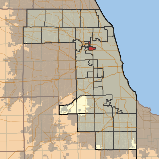
Norwood Park Township is one of 29 townships in Cook County, Illinois, USA. As of the 2020 census, its population was 27,441.

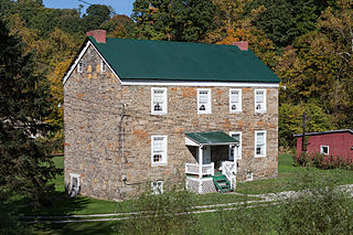
Signal Hill is an unincorporated community in Centreville Township, Stookey Township, and the city of Belleville, St. Clair County, Illinois, United States. Signal Hill is located on Illinois Route 157, approximately 11 miles (18 km) southeast of St. Louis, Missouri. Signal Hill dates back to 1904, during the Saint Louis World Fair, when the Signal Hill Park addition was platted. The tree-lined, island separated, boulevard is the centerpiece of the community filled with large, elegant homes dated to the creation of the community.

<span class="mw-page-title-main">Alabama City, Alabama</span> Former City in Alabama, United States

Alabama City is a former city and now a neighborhood within the city of Gadsden in Etowah County, Alabama, United States. It was equidistant between Gadsden and Attalla, Alabama, approximately 2 1/2 miles west of downtown Gadsden.

References

  1. "Population and Housing Unit Estimates". Census.gov. Retrieved June 9, 2017.
  2. 1 2 "Population, Housing Units, Area, and Density: 2010 - County -- County Subdivision and Place -- 2010 Census Summary File 1". United States Census. Archived from the original on February 12, 2020. Retrieved May 28, 2013.
  3. 1 2 "The Demographic Statistical Atlas of the United States - Statistical Atlas".
  4. https://www2.census.gov/prod2/decennial/documents/36894832v2ch04.pdf . Retrieved May 27, 2024.{{cite web}}: Missing or empty |title= (help)
  5. https://www2.census.gov/prod2/decennial/documents/36894832v2ch04.pdf . Retrieved May 27, 2024.{{cite web}}: Missing or empty |title= (help)
  6. https://www2.census.gov/prod2/decennial/documents/41084506no553ch2.pdf . Retrieved May 27, 2024.{{cite web}}: Missing or empty |title= (help)
  7. https://www2.census.gov/prod2/decennial/documents/41084506no553ch2.pdf . Retrieved May 27, 2024.{{cite web}}: Missing or empty |title= (help)
  8. https://www2.census.gov/library/publications/decennial/1950/population-volume-1/vol-01-16.pdf . Retrieved May 27, 2024.{{cite web}}: Missing or empty |title= (help)
  9. https://www2.census.gov/library/publications/decennial/1950/population-volume-1/vol-01-16.pdf . Retrieved May 27, 2024.{{cite web}}: Missing or empty |title= (help)
  10. https://www2.census.gov/library/publications/decennial/1950/population-volume-1/vol-01-16.pdf . Retrieved May 27, 2024.{{cite web}}: Missing or empty |title= (help)
  11. https://www2.census.gov/library/publications/decennial/1980/volume-1/illinois/1980a_ilab-01.pdf . Retrieved May 27, 2024.{{cite web}}: Missing or empty |title= (help)
  12. https://www2.census.gov/library/publications/decennial/1980/volume-1/illinois/1980a_ilab-01.pdf . Retrieved May 27, 2024.{{cite web}}: Missing or empty |title= (help)
  13. https://www2.census.gov/library/publications/decennial/1980/volume-1/illinois/1980a_ilab-01.pdf . Retrieved May 27, 2024.{{cite web}}: Missing or empty |title= (help)
  14. https://data.census.gov/table/DECENNIALSF12010.P1?q=Stookey%20township,%20St.%20Clair%20County,%20Illinois&y=2010 . Retrieved May 27, 2024.{{cite web}}: Missing or empty |title= (help)
  15. . Census.gov https://data.census.gov/all?q=Stookey%20township,%20St.%20Clair%20County,%20Illinois . Retrieved May 27, 2024.{{cite web}}: Missing or empty |title= (help)
  16. . Census.gov https://data.census.gov/all?q=Stookey%20township,%20St.%20Clair%20County,%20Illinois . Retrieved May 27, 2024.{{cite web}}: Missing or empty |title= (help)
  17. "Census of Population and Housing". Census.gov. Retrieved June 4, 2016.
  18. "Census profile: Stookey township, St. Clair County, IL". Census Reporter.
  19. "Google Sites: Sign-in". accounts.google.com.
  20. District 201, BTHS. "District".{{cite web}}: CS1 maint: numeric names: authors list (link)
  21. "Harmony-Emge School District #175". www.harmony175.org.
  22. "New Burger King location set to open next week - Belleville News-Democrat". Belleville News-Democrat. September 1, 2017. Archived from the original on September 2, 2017. Retrieved September 15, 2023.

38°31′11″N90°05′24″W / 38.51972°N 90.09000°W / 38.51972; -90.09000