
An earthquake is the shaking of the surface of the Earth resulting from a sudden release of energy in the Earth's lithosphere that creates seismic waves. Earthquakes can range in size from those that are so weak that they cannot be felt to those violent enough to propel objects and people into the air, and wreak destruction across entire cities. The seismicity, or seismic activity, of an area is the frequency, type, and size of earthquakes experienced over a particular time period. The word tremor is also used for non-earthquake seismic rumbling.

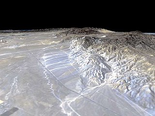
The San Andreas Fault is a continental transform fault that extends roughly 1,200 kilometers (750 mi) through California. It forms the tectonic boundary between the Pacific Plate and the North American Plate, and its motion is right-lateral strike-slip (horizontal). The fault divides into three segments, each with different characteristics and a different degree of earthquake risk. The slip rate along the fault ranges from 20 to 35 mm /yr. It was formed by a transform boundary.
The Garlock Fault is a left-lateral strike-slip fault running northeast–southwest along the north margins of the Mojave Desert of Southern California, for much of its length along the southern base of the Tehachapi Mountains.

The 1999 Hector Mine earthquake occurred in Southern California, United States, on October 16 at 02:46:50 PDT. Its moment magnitude was 7.1 and the earthquake was preceded by 12 foreshocks, the largest of which had a magnitude of 3.8. The Hector Mine earthquake is also thought to have been triggered by the 1992 Landers Earthquake that occurred seven years prior. The earthquake caused minimal damage due to the distance of its epicenter from any population centers. It also deformed nearby faults vertically and horizontally. The earthquake's hypocenter was at a depth of 20 kilometers and its epicenter at 34.603° N 116.265° W. Due to the time and place at which the earthquake occurred, there was little damage to the surrounding area as well as zero deaths. The significance of this earthquake lies in the fact that, firstly, it had a relatively-high magnitude but caused little damage and secondly, it offered more evidence that stress accumulation over time causes earthquakes.

The 1992 Landers earthquake occurred on Sunday, June 28 with an epicenter near the town of Landers, California, in San Bernardino County. The shock had a moment magnitude of 7.3 and a maximum Mercalli intensity of IX (Violent).
The Walker Lane is a geologic trough roughly aligned with the California/Nevada border southward to where Death Valley intersects the Garlock Fault, a major left lateral, or sinistral, strike-slip fault. The north-northwest end of the Walker Lane is between Pyramid Lake in Nevada and California's Lassen Peak where the Honey Lake Fault Zone, the Warm Springs Valley Fault, and the Pyramid Lake Fault Zone meet the transverse tectonic zone forming the southern boundary of the Modoc Plateau and Columbia Plateau provinces. The Walker Lane takes up 15 to 25 percent of the boundary motion between the Pacific Plate and the North American Plate, the other 75 percent being taken up by the San Andreas Fault system to the west. The Walker Lane may represent an incipient major transform fault zone which could replace the San Andreas as the plate boundary in the future.

The Wabash Valley Seismic Zone is a tectonic region located in the Midwest of the United States, centered on the valley of the Lower Wabash River, along the state line between southeastern Illinois and southwestern Indiana.
The 1986 Chalfant Valley earthquake struck southern Mono County near Bishop and Chalfant, California at Pacific Daylight Time on July 21. With a moment magnitude of 6.2 and a maximum Mercalli intensity of VI (Strong), the shock injured two people and caused property damage estimated at $2.7 million in the affected areas. There was a significant foreshock and aftershock sequence that included a few moderate events, and was the last in a series of three earthquakes that affected southern California and the northern Owens Valley in July 1986.
The 1940 El Centro earthquake occurred at 21:35 Pacific Standard Time on May 18 in the Imperial Valley in southeastern Southern California near the international border of the United States and Mexico. It had a moment magnitude of 6.9 and a maximum perceived intensity of X (Extreme) on the Mercalli intensity scale. It was the first major earthquake to be recorded by a strong-motion seismograph located next to a fault rupture. The earthquake was characterized as a typical moderate-sized destructive event with a complex energy release signature. It was the strongest recorded earthquake to hit the Imperial Valley, and caused widespread damage to irrigation systems and led to the deaths of nine people.
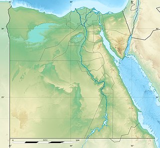
The 1995 Gulf of Aqaba earthquake occurred on November 22 at 06:15 local time and registered 7.3 on the scale. The epicenter was located in the central segment of the Gulf of Aqaba, the narrow body of water that separates Egypt's Sinai Peninsula from the western border of Saudi Arabia. At least 8 people were killed and 30 were injured in the meizoseismal area.
The 1979 Imperial Valley earthquake occurred at 16:16 Pacific Daylight Time on 15 October just south of the Mexico–United States border. It affected Imperial Valley in Southern California and Mexicali Valley in northern Baja California. The earthquake had a relatively shallow hypocenter and caused property damage in the United States estimated at US$30 million. The irrigation systems in the Imperial Valley were badly affected, but no deaths occurred. It was the largest earthquake to occur in the contiguous United States since the 1971 San Fernando earthquake eight years earlier.
The 2000 Yountville earthquake occurred with a moment magnitude of 5 on a previously unmapped fault, about 3 miles (4.8 km) south southwest of Yountville, California in the Mayacamas Mountain Range under Mount Veeder and about 9 miles (14 km) south northwest of Napa, California. It occurred at 01:36 PDT on September 3.
The 2019 Ridgecrest earthquakes of July 4 and 5 occurred north and northeast of the town of Ridgecrest, California located in Kern County and west of Searles Valley. They included three initial main shocks of magnitudes 6.4, 5.4, and 7.1, and many perceptible aftershocks, mainly within the area of the Naval Air Weapons Station China Lake. Eleven months later, a Mw 5.5 aftershock took place to the east of Ridgecrest. The first main shock occurred on Thursday, July 4 at 10:33 a.m. PDT, approximately 18 km (11.2 mi) ENE of Ridgecrest, and 13 km (8.1 mi) WSW of Trona, on a previously unnoticed NE-SW trending fault where it intersects the NW-SE trending Little Lake Fault Zone. This quake was preceded by several smaller earthquakes, and was followed by more than 1,400 detected aftershocks. The M 5.4 and M 7.1 quakes struck on Friday, July 5 at 4:08 a.m. and 8:19 p.m. PDT approximately 10 km (6 miles) to the northwest. The latter, now considered the mainshock, was the most powerful earthquake to occur in the state in 20 years. Subsequent aftershocks extended approximately 50 km (~30 miles) along the Little Lake Fault Zone.
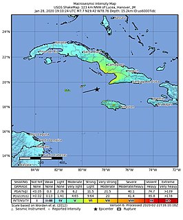
At 2:10 p.m. local time (UTC-5) on 28 January 2020, an earthquake of 7.7 struck on the north side of the Cayman Trough, north of Jamaica and west of the southern tip of Cuba, with the epicenter being 80 miles (130 km) ESE of Cayman Brac, Cayman Islands or 83 miles (134 km) north of Montego Bay, Jamaica. Schools in Jamaica and buildings in Miami were evacuated after shaking was observed in parts of the U.S. state of Florida. Light shaking was also reported on the Yucatan peninsula in Mexico. It is the largest earthquake in the Caribbean since 1946. A tsunami warning for the Caribbean Sea was issued by the Pacific Tsunami Warning Center and later withdrawn.

On May 15, 2020 at 4:03:27 local time, a magnitude 6.5 earthquake struck ~35 miles (56 km) west of Tonopah, Nevada in the Monte Cristo Range near the California-Nevada border. It was Nevada's largest earthquake in 66 years.
The 1987 Superstition Hills and Elmore Ranch earthquakes were a pair of earthquakes Mw 6.2 and 6.6 that rattled the Imperial Valley of California. The earthquakes caused damage to places in California and Mexico, and was felt as far as Las Vegas and Phoenix. Both main shocks were larger than the deadly earthquake that struck Los Angeles on October 1, which was a magnitude 5.9.
In 1954, the state of Nevada was struck by a series of earthquakes that began with three M 6.0+ events in July and August that preceded the M 7.3 mainshock and M 6.9 aftershock, both on December 12. All five earthquakes remain some of the largest in the state, and the largest since the Cedar Mountain earthquake of 1932 and Pleasant Valley event in 1915. The earthquake was felt throughout much of the western United States.
The Cedar Mountain earthquake of 1932 was one of the largest seismic events in the US state of Nevada. The 7.2 magnitude earthquake struck at the base of Cedar Mountain in Western Nevada. Shaking from this earthquake was felt as far as Oregon, Southern California, and the Rocky Mountains area. Nevada is the third most seismically active state in the United States due to ongoing rifting occurring within the North American Plate. Extension or thinning of the crust has resulted in numerous faults accommodating strain, at the same time, producing earthquakes. Since the earthquake took place in a remote area of the state, there were slight damages but no deaths were reported.
The 1968 Borrego Mountain earthquake occurred on the evening of April 8, near the unincorporated community of Ocotillo Wells in San Diego County. The moment magnitude 6.6 earthquake was assigned a maximum intensity of VII on the Mercalli intensity scale, causing some damage in the Imperial Valley, but no injuries or deaths. Shaking from this earthquake was widely felt, even in Nevada, and Arizona. It was the largest earthquake in Southern California since the 1952 Kern County earthquake 16 years prior.

An earthquake occurred off the coast of the Alaska Peninsula on July 28, 2021, at 10:15 p.m. local time. The large megathrust earthquake had a moment magnitude of 8.2 according to the United States Geological Survey (USGS). A tsunami warning was issued by the National Oceanic and Atmospheric Administration (NOAA) but later cancelled. The mainshock was followed by a number of aftershocks, including three that were of magnitude 5.9, 6.1 and 6.9 respectively.


