The ALSE (Apollo Lunar Sounder Experiment) (also known as Scientific Experiment S-209, according to NASA designations) was a ground-penetrating radar (subsurface sounder) experiment that flew on the Apollo 17 mission.
Contents

The ALSE (Apollo Lunar Sounder Experiment) (also known as Scientific Experiment S-209, according to NASA designations) was a ground-penetrating radar (subsurface sounder) experiment that flew on the Apollo 17 mission.
This experiment used radar to study the Moon's surface and interior. Radar waves with wavelengths between 2 and 60 meters (frequencies of 5, 15, and 150 MHz) were transmitted through a series of antennas near the back of the Apollo Service Module. After the waves were reflected by the Moon, they were received using the same antennas and the data was recorded on film for analysis on Earth. The primary purpose of this experiment was to "see" into the upper 2 kilometers of the Moon's crust in a manner somewhat analogous to using seismic waves to study the internal structure of the Moon. This was possible because very long radar wavelengths were used and because the Moon is very dry, which allowed the radar waves to penetrate much deeper into the Moon than would have been possible if water were present in lunar rocks. (A radar experiment on the Space Shuttle has been similarly used to map ancient river valleys beneath the Sahara Desert.) This experiment also provided very precise information about the Moon's topography. In addition to studying the Moon, the experiment also measured radio emissions from the Milky Way galaxy.


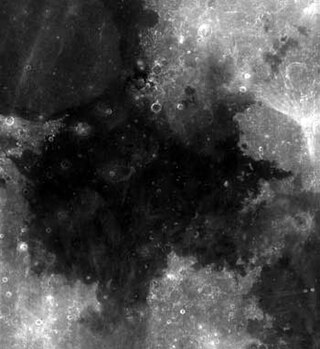
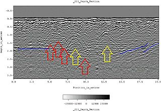
This experiment revealed structures beneath the surface in Mare Crisium, Mare Serenitatis, Oceanus Procellarum, and many other areas. [1] In the mare areas, layers were observed in several different parts of the basins and are therefore believed to be widespread features. Based on the properties of the reflected radar waves, the structures are believed to be layering within the basalt that fills both of these mare basins. In Mare Serenitatis, layers were detected at depths of 0.9 and 1.6 kilometers below the surface. In Mare Crisium, a layer was detected at a depth of 1.4 kilometers below the surface. The bottom of the mare basalts were apparently not detected by this experiment. However, in Mare Crisium the Lunar Sounder Experiment results were combined with other observations to estimate a total basalt thickness of between 2.4 and 3.4 kilometers.
The Lunar Sounder Experiment also contributed to our understanding of wrinkle ridges on the Moon. These long, low ridges are found in many of the lunar maria. Most lunar geologists believe that these ridges formed when the Moon's surface was deformed by motion along faults ("moonquakes") in the Moon's crust more than 3 billion years ago. The weight of several kilometers of mare basalt in these areas caused the Moon's surface to sag somewhat, and this motion caused the surface to buckle in some places, forming the wrinkle ridges. However, other scientists suggested that these ridges are volcanic features, formed by the flow of magma either on the Moon's surface or within the crust. The Lunar Sounder Experiment studied several wrinkle ridges in southern Mare Serenitatis in detail, providing information about both the topography of these ridges and about structures in the crust below these ridges. These results support the idea that wrinkle ridges formed primarily by motions along faults. [2]
The ALSE instrument operated in two HF bands (5 MHz: HF1 and 15 MHz: HF2) center frequencies and one VHF band (150 MHz), each with a bandwidth of 10% (using a chirped signal). The two HF bands shared the same center-feed dipole antenna, while a 7-element Yagi antenna was used for the VHF channel. Two different transceiver were used for the HF (alternating operation between HF1 and HF2 on a PRF-by-PRF basis) and VHF, sharing a common optical recorder. It was not possible to operate in VHF and HF simultaneously. The whole system weighed 43 kg and required 103 W of power. The electronics was located inside the Apollo Service Module. The two halves of the dipole antenna were retractable, on the two sides of the service module itself, while the Yagi used for VHF was stowed close to the main engine and then deployed into position after launch.
Being the primary objective of the experiment the mapping of subsurface layers, the most critical trade-off in the design was that of penetration depth vs resolution: lower frequencies penetrates more, but allowed a smaller signal bandwidth and, therefore, a worst resolution which, in turn, affected the capability to discriminate subsurface echoes close to the surface. The sounding capability was also affected by:
Clutter from across-track scatterers had instead to be inferred from the knowledge of the surface topography.
An automatic gain control (AGC) feature was included in all the channels to optimize the signal allocation within the receiver dynamic range. The AGC update rate was 30 s. In both the HF and VHF transceivers, the chirp signal was generated by a swept oscillator synchronized with a STAble Local Oscillator (STALO) in order to preserve the phase coherency for the SAR processing. The received signal was converted at IF and the signal amplitude was used to amplitude-modulate a CRT (swept at PRF rate), in turn impressing a 70 mm film for optical recording of the data. Due to the high recording speed required for the wider bandwidth VHF channel, to minimize the amount of recorded data, this channel used an echo tracking system to acquire and record only the main surface return and the 70 μs of echoes immediately following it. Additionally, on this channel, the receiver gain was increased 13 μs after the arrival of the main surface echo to best exploit the dynamic range on weak subsurface returns.
Since the recorder was located in the service module, astronaut Ron Evans performed an Extra-Vehicular Activity (EVA) during the return flight from the Moon to collect the recorded films.
The processing facility on ground allowed for both full optical processing (at that time, the standard approach for SAR processing) performing azimuth and/or range compression, or digitization of rough or azimuth-compressed data for later digital processing.
During the developments phase, a modified ALSE prototype was installed on board a KC-135 aircraft to perform sounding tests over the southeast US and over Greenland, demonstrating the capabilities of the system.
The main parameters of the ALSE radar are summarized in the table below: [3]
| Property | HF1 | HF2 | VHF |
|---|---|---|---|
| Frequency (MHz) | 5.266 | 15.8 | 158 |
| Estimated depth of penetration (m) | 1300 | 800 | 160 |
| Chirp bandwidth (MHz) | 0.5333 | 1.6 | 16.0 |
| Pulse width (μs) | 240 | 80 | 8.0 |
| Time (bandwidth product) | 128 | 128 | 128 |
| Range resolution, free space (m) | 300 | 100 | 10 |
| Transmitter peak power (W) | 130 | 118 | 95 |
| Antenna effective Gain (dB one-way) | –0.8 | –0.7 | +7.3 |
| Noise Figure (dB) | 11.4 | 11.4 | 10.0 |
| Pulse Repetition Frequency (Hz) | 397 | 397 | 1984 |
| Acquisition window length (μs) | 600 | 600 | 70 |
| AGC Gain Range (dB) | 12.1 | 12.1 | 13.9 |
| Echo tracker | No | No | Yes |

Mare Crisium is a lunar mare located in the Moon's Crisium basin, just northeast of Mare Tranquillitatis. Mare Crisium is a basin of Nectarian age.
Mare Tranquillitatis is a lunar mare that sits within the Tranquillitatis basin on the Moon. It contains Tranquility Base, the first location on another celestial body to be visited by humans.

Mare Serenitatis is a lunar mare located to the east of Mare Imbrium on the Moon. Its diameter is 674 km (419 mi).

The Fra Mauro formation is a formation on the near side of Earth's Moon that served as the landing site for the American Apollo 14 mission in 1971. It is named after the 80-kilometer-diameter crater Fra Mauro, located within it. The formation, as well as Fra Mauro crater, take their names from a 15th-century Italian monk and mapmaker of the same name. Apollo 13 was originally scheduled to land in the Fra Mauro highlands, but was unable due to an in-flight technical failure.

The lunar geological timescale divides the history of Earth's Moon into five generally recognized periods: the Copernican, Eratosthenian, Imbrian, Nectarian, and Pre-Nectarian. The boundaries of this time scale are related to large impact events that have modified the lunar surface, changes in crater formation through time, and the size-frequency distribution of craters superposed on geological units. The absolute ages for these periods have been constrained by radiometric dating of samples obtained from the lunar surface. However, there is still much debate concerning the ages of certain key events, because correlating lunar regolith samples with geological units on the Moon is difficult, and most lunar radiometric ages have been highly affected by an intense history of bombardment.
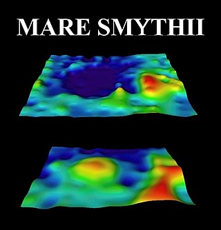
In astronomy, astrophysics and geophysics, a mass concentration is a region of a planet's or moon's crust that contains a large positive gravity anomaly. In general, the word "mascon" can be used as a noun to refer to an excess distribution of mass on or beneath the surface of an astronomical body, such as is found around Hawaii on Earth. However, this term is most often used to describe a geologic structure that has a positive gravitational anomaly associated with a feature that might otherwise have been expected to have a negative anomaly, such as the "mascon basins" on the Moon.

The lunar maria are large, dark, basaltic plains on Earth's Moon, formed by lava flowing into ancient impact basins. They were dubbed maria by early astronomers who mistook them for actual seas. They are less reflective than the "highlands" as a result of their iron-rich composition, and hence appear dark to the naked eye. The maria cover about 16% of the lunar surface, mostly on the side visible from Earth. The few maria on the far side are much smaller, residing mostly in very large craters. The traditional nomenclature for the Moon also includes one oceanus (ocean), as well as features with the names lacus ('lake'), palus ('marsh'), and sinus ('bay'). The last three are smaller than maria, but have the same nature and characteristics.
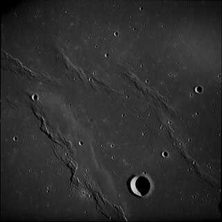
A wrinkle ridge is a type of feature commonly found on lunar maria, or basalt plains. These features are low, sinuous ridges formed on the mare surface that can extend for up to several hundred kilometers. Wrinkle ridges are tectonic features created after the lava cooled and solidified. They frequently outline ring structures buried within the mare, follow circular patterns outlining the mare, or intersect protruding peaks. They are sometimes called veins due to their resemblance to the veins that protrude from beneath the skin.
Earth–Moon–Earth communication (EME), also known as Moon bounce, is a radio communications technique that relies on the propagation of radio waves from an Earth-based transmitter directed via reflection from the surface of the Moon back to an Earth-based receiver.
Ground-penetrating radar (GPR) is a geophysical method that uses radar pulses to image the subsurface. It is a non-intrusive method of surveying the sub-surface to investigate underground utilities such as concrete, asphalt, metals, pipes, cables or masonry. This nondestructive method uses electromagnetic radiation in the microwave band of the radio spectrum, and detects the reflected signals from subsurface structures. GPR can have applications in a variety of media, including rock, soil, ice, fresh water, pavements and structures. In the right conditions, practitioners can use GPR to detect subsurface objects, changes in material properties, and voids and cracks.

Space-based radar or spaceborne radar is a radar operating in outer space; orbiting radar is a radar in orbit and Earth orbiting radar is a radar in geocentric orbit. A number of Earth-observing satellites, such as RADARSAT, have employed synthetic aperture radar (SAR) to obtain terrain and land-cover information about the Earth.

Lacus Somniorum is a basaltic plain located in the northeastern part of the Moon's near side. It is located at selenographic coordinates 37.56° N, 30.8° E, and has a diameter of 424.76 kilometers. The name is Latin for Lake of Dreams, a title given to this feature by Giovanni Riccioli. It is the largest of the lunar features designated Lacus.

MARSIS is a low frequency, pulse-limited radar sounder and altimeter developed by the University of Rome La Sapienza and Alenia Spazio. The Italian MARSIS instrument, which is operated by the European Space Agency, is operational and orbits Mars as an instrument for the ESA's Mars Express exploration mission.

The geology of the Moon is quite different from that of Earth. The Moon lacks a true atmosphere, and the absence of free oxygen and water eliminates erosion due to weather. Instead, the surface is eroded much more slowly through the bombardment of the lunar surface by micrometeorites. It does not have any known form of plate tectonics, it has a lower gravity, and because of its small size, it cooled faster. In addition to impacts, the geomorphology of the lunar surface has been shaped by volcanism, which is now thought to have ended less than 50 million years ago. The Moon is a differentiated body, with a crust, mantle, and core.

Explorer 49 was a NASA 328 kg (723 lb) satellite launched on 10 June 1973, for long wave radio astronomy research. It had four 230 m (750 ft) X-shaped antenna elements, which made it one of the largest spacecraft ever built.

SHARAD is a subsurface sounding radar embarked on the Mars Reconnaissance Orbiter (MRO) probe. It complements the MARSIS radar on Mars Express orbiter, providing lower penetration capabilities but much finer resolution.

Taurus–Littrow is a lunar valley located on the near side at the coordinates 20.0°N 31.0°E. It served as the landing site for the American Apollo 17 mission in December 1972, the last crewed mission to the Moon. The valley is located on the southeastern edge of Mare Serenitatis along a ring of mountains formed between 3.8 and 3.9 billion years ago when a large object impacted the Moon, forming the Serenitatis basin and pushing rock outward and upward.
The Imbrian is a lunar geologic period divided into two epochs, the Early and Late.

The Radar for Europa Assessment and Sounding: Ocean to Near-surface (REASON) is a multi-frequency, multi-channel ice penetrating radar system that will be flown on board the Europa Clipper mission to Jupiter's moon Europa. REASON investigation will provide the first direct measurements of Europa's ice shell surface character and subsurface structure.

Volcanism on the Moon is represented by the presence of volcanoes, pyroclastic deposits and vast lava plains on the lunar surface. The volcanoes are typically in the form of small domes and cones that form large volcanic complexes and isolated edifices. Calderas, large-scale collapse features generally formed late in a volcanic eruptive episode, are exceptionally rare on the Moon. Lunar pyroclastic deposits are the result of lava fountain eruptions from volatile-laden basaltic magmas rapidly ascending from deep mantle sources and erupting as a spray of magma, forming tiny glass beads. However, pyroclastic deposits formed by less common non-basaltic explosive eruptions are also thought to exist on the Moon. Lunar lava plains cover large swaths of the Moon's surface and consist mainly of voluminous basaltic flows. They contain a number of volcanic features related to the cooling of lava, including lava tubes, rilles and wrinkle ridges.
| Launch complexes |  | ||||||||||
|---|---|---|---|---|---|---|---|---|---|---|---|
| Ground facilities | |||||||||||
| Launch vehicles | |||||||||||
| Spacecraft and rover | |||||||||||
| Flights |
| ||||||||||
| Apollo 8 specific | |||||||||||
| Apollo 11 specific | |||||||||||
| Apollo 12 specific | |||||||||||
| Apollo 13 specific | |||||||||||
| Apollo 14 specific | |||||||||||
| Apollo 15 specific | |||||||||||
| Apollo 16 specific | |||||||||||
| Apollo 17 specific | |||||||||||
| Post-Apollo capsule use | |||||||||||
| Related | |||||||||||
| |||||||||||
| Launch vehicles | |
|---|---|
| Launch vehicle components | |
| Spacecraft | |
| Spacecraft components | |
| Space suits | |
| Lunar surface equipment |
|
| Ground support | |
| Ceremonial | |
| Related | |