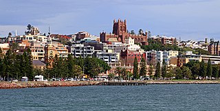
Newcastle is a metropolitan area and the second most populated city in the state of New South Wales, Australia. It includes the Newcastle and Lake Macquarie local government areas, and is the hub of the Greater Newcastle area, which includes most parts of the local government areas of City of Newcastle, City of Lake Macquarie, City of Cessnock, City of Maitland and Port Stephens Council.
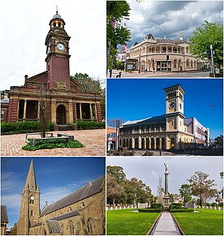
Maitland is a city in the Lower Hunter Valley of New South Wales, Australia and the seat of Maitland City Council, situated on the Hunter River approximately 166 kilometres (103 mi) by road north of Sydney and 35 km (22 mi) north-west of Newcastle. It is on the New England Highway approximately 17 km (11 mi) from its origin at Hexham.
Morisset is a commercial centre and suburb of the City of Lake Macquarie, Central Coast in New South Wales, Australia, and is located west of Lake Macquarie just off the Sydney-Newcastle Freeway. It is also located approximately halfway between Gosford and Newcastle. The count at the 2016 Census was 3,213 for the gazetted suburb of Morisset. The estimated urban population of the Morisset area, including Cooranbong, was 25,662 as at June 2019. The area has experienced moderate growth over the five years to 2019 with an average year-on-year rate of 1.79 percent.

Hornsby is a suburb in the Northern Sydney region, or Upper North Shore of Sydney in the state of New South Wales, Australia, approximately 23 kilometres (14 mi) north-west of the Sydney central business district. It is the administrative centre of the local government area of Hornsby Shire.

The Hunter Region, also commonly known as the Hunter Valley, is a region of New South Wales, Australia, extending from approximately 120 km (75 mi) to 310 km (193 mi) north of Sydney. It contains the Hunter River and its tributaries with highland areas to the north and south. Situated at the northern end of the Sydney Basin bioregion, the Hunter Valley is one of the largest river valleys on the NSW coast, and is most commonly known for its wineries and coal industry.
The Hunter River is a major river in New South Wales, Australia. The Hunter River rises in the Liverpool Range and flows generally south and then east, reaching the Tasman Sea at Newcastle, the second largest city in New South Wales and a major harbour port. Its lower reaches form an open and trained mature wave dominated barrier estuary.

Port Stephens, an open youthful tide-dominated drowned-valley estuary, is a large natural harbour of approximately 134 square kilometres (52 sq mi) located in the Hunter Region of New South Wales, Australia.

Narrabeen is a beachside suburb in northern Sydney, in the state of New South Wales, Australia. Narrabeen is 23 kilometres north-east of the Sydney central business district, in the local government area of Northern Beaches Council and is part of the Northern Beaches region. This area was named Broken Bay by James Cook as he sailed by.

Morpeth is a suburb of the city of Maitland in the Hunter Region of New South Wales, Australia. It is on the southern banks of the Hunter River at the border between the City of Maitland and Port Stephens Council LGAs. The major population centre, where almost all residents of the suburb reside, is the historical town of Morpeth which takes its name from Morpeth, Northumberland, near Newcastle upon Tyne, in England.

Maitland railway station is located on the Main Northern line in New South Wales, Australia. It serves the city of Maitland opening on in 1880 as West Maitland being renamed on 1 April 1949. It is the junction station for the Main Northern and North Coast lines. It was added to the New South Wales State Heritage Register on 2 April 1999.

Woodville is a rural suburb in the Hunter Region of New South Wales, Australia that is shared between the Port Stephens and Maitland local government areas (LGA). Most of the suburb lies to the east of the Paterson River in the Port Stephens LGA while a small area of approximately 1.3 square kilometres (0.5 sq mi), to the west of the Paterson, is within the boundaries of the Maitland LGA.
Thornton is a suburb in the City of Maitland, New South Wales, Australia. It is bisected by the New England Highway.
East Maitland is a suburb in the City of Maitland, New South Wales, Australia. It is on the New England Highway and it has two railway stations, Victoria Street and East Maitland. Both stations are served by NSW TrainLink's Hunter Line. Hunter Valley Buses provides bus service.
Hamilton is a suburb of Newcastle, New South Wales, Australia, located 4 kilometres (2.5 mi) from Newcastle's central business district. The main commercial centre is located around Beaumont Street and boasts a vibrant multicultural atmosphere providing an array of restaurants, retail, fashion and commercial outlets along with day-to-day services such as pharmacies, banks, florists, hairdressers, fruit shops and delicatessens.
New Lambton Heights is a suburb of Newcastle, New South Wales, Australia, located 9 kilometres (6 mi) west of Newcastle's central business district. It is split between the City of Lake Macquarie and City of Newcastle local government areas.

Tomago is a combined industrial/semi-rural suburb of the Port Stephens local government area in the Hunter Region of New South Wales, Australia. It is located just north of the Hunter River and west of the body of water known as Fullerton Cove. Tomago means "sweet water" in the local Aboriginal language. In 2016 277 lived in Tomago with a median age of 55, 72.7% born in Australia and 80.4% only speaking English at home.
Minmi is an outer western suburb of Newcastle, New South Wales, Australia, located 19 kilometres (12 mi) from Newcastle's central business district. It is part of the City of Newcastle local government area.

Karuah River, an open semi-mature tide dominated drowned valley estuary is located in the Mid North Coast and Hunter regions of New South Wales, Australia.
Bolwarra Heights is a suburb in the City of Maitland in the Hunter Region of New South Wales, Australia. It is located on the eastern side of the Hunter River, approximately 5 km (3.1 mi) north of the Maitland central business district. Mainly a residential suburb, Bolwarra Heights is bordered to the east by Largs. The traditional owners and custodians of the Maitland area are the Wonnarua people.
South Maitland is an inner city suburb in the City of Maitland in the Hunter Region of New South Wales, Australia. It is located immediately south of the New England Highway and Main North railway line, which separate the suburb from the Maitland central business district. Pedestrian overpasses are provided to cross the highway allowing access to both High Street and Maitland stations from South Maitland. The suburb contains a mixture of parkland, rural and residential development, with a population of 471 in 2016.
