Adairville, Kentucky

Last updated

Adairville, Kentucky
Adairville-KY591-ky.jpg
Gallatin Street (KY 591) in Adairville
Logan County Kentucky Incorporated and Unincorporated areas Adairville Highlighted 2100298.svg
Location in Logan County, Kentucky
Coordinates: 36°40′7″N86°51′14″W / 36.66861°N 86.85389°W / 36.66861; -86.85389
Country United States
State Kentucky
County Logan
Government
  MayorDonna Blake
Area
[1]
  Total1.18 sq mi (3.05 km2)
  Land1.18 sq mi (3.04 km2)
  Water0.00 sq mi (0.00 km2)
Elevation
600 ft (183 m)
Population
 (2020)
  Total837
  Density712.34/sq mi (274.95/km2)
Time zone UTC-6 (Central (CST))
  Summer (DST) UTC-5 (CDT)
ZIP code
42202
Area code 270
FIPS code 21-00298
GNIS feature ID0485749
Website adairvilleky.us

Adairville is a home rule-class city in Logan County, Kentucky, in the United States. Established on January 31, 1833, it was named for Governor John Adair and incorporated by the state assembly on February 7, 1871. [2] [3] The population was 852 at the 2010 census. [4]

Contents

In a duel, future president Andrew Jackson killed Charles Dickinson here in 1806. [5]

History

Adairville was settled in the late 18th century, and was originally known as "Dromgooles' Station". Red River Meeting House was built in 1800 near the town and was the sight of the first religious camp meeting in the United States. It was the birthplace of the Second Great Awakening. When a town was platted in 1818, its name was changed to "Adairsville" in honor the prominent Kentucky politician. The city was incorporated in 1833. The "s" had been dropped from the name by 1881. [6]

Geography

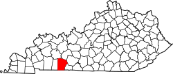
Adairville is in southern Logan County, 1.5 miles (2.4 km) north of the Kentucky–Tennessee state line. The city is concentrated around the intersection of U.S. Route 431 (Main Street) and Kentucky Route 591 (Gallatin Street). US 431 leads north 13 miles (21 km) to Russellville, the Logan county seat, and south 12 miles (19 km) to Springfield, Tennessee. Larger cities in the region are Bowling Green, Kentucky, 36 miles (58 km) to the northeast; Clarksville, Tennessee, the same distance to the southwest; and Nashville, Tennessee, 38 miles (61 km) to the south.

According to the United States Census Bureau, Adairville has a total area of 1.2 square miles (3.0 km2), of which 1.22 acres (4,945 m2), or 0.16%, are water. [7] The South Fork of the Red River passes along the city's southern border, and the Red River proper passes a few miles to the north.

Demographics

Historical population
CensusPop.Note
1860 148
1870 21444.6%
1880 476122.4%
1900 720
1910 683−5.1%
1920 77813.9%
1930 763−1.9%
1940 7842.8%
1950 8002.0%
1960 8486.0%
1970 97314.7%
1980 1,10513.6%
1990 906−18.0%
2000 9201.5%
2010 852−7.4%
2020 837−1.8%
U.S. Decennial Census [8]

As of the census [9] of 2000, there were 920 people, 398 households, and 267 families residing in the city. The population density was 704.8 inhabitants per square mile (272.1/km2). There were 431 housing units at an average density of 330.2 per square mile (127.5/km2). The racial makeup of the city was 79.13% White, 18.70% African American, 0.43% Native American, 0.87% from other races, and 0.87% from two or more races. Hispanic or Latino of any race were 2.61% of the population.

There were 398 households, out of which 28.4% had children under the age of 18 living with them, 47.2% were married couples living together, 16.8% had a female householder with no husband present, and 32.9% were non-families. 31.4% of all households were made up of individuals, and 16.3% had someone living alone who was 65 years of age or older. The average household size was 2.31 and the average family size was 2.79.

In the city, the population was spread out, with 23.5% under the age of 18, 7.4% from 18 to 24, 26.4% from 25 to 44, 26.1% from 45 to 64, and 16.6% who were 65 years of age or older. The median age was 40 years. For every 100 females, there were 85.9 males. For every 100 females age 18 and over, there were 79.6 males.

The median income for a household in the city was $27,266, and the median income for a family was $40,139. Males had a median income of $26,618 versus $20,568 for females. The per capita income for the city was $15,490. About 9.6% of families and 13.9% of the population were below the poverty line, including 14.9% of those under age 18 and 21.1% of those age 65 or over.

Education

Adairville has a lending library, a branch of the Logan County Public Library. [10]

Related Research Articles

<span class="mw-page-title-main">Robertson County, Tennessee</span> County in Tennessee, United States

Robertson County is a county located on the central northern border of Tennessee in the United States. As of the 2020 United States Census, the population was 72,803 people. Its county seat is Springfield. The county was named for James Robertson, an explorer, founder of Nashville, and a state senator, who was often called the "Father of Middle Tennessee." Robertson County is a component of the Nashville-Davidson–Murfreesboro–Franklin, TN Metropolitan Statistical Area.

<span class="mw-page-title-main">Simpson County, Kentucky</span> County in Kentucky, United States

Simpson County is a county located in the south central portion of the U.S. state of Kentucky. As of the 2020 census, the total population was 19,594. Its county seat is Franklin.

<span class="mw-page-title-main">Logan County, Kentucky</span> County in Kentucky, United States

Logan County is a county in the southwest Pennyroyal Plateau area of the U.S. Commonwealth of Kentucky. As of the 2020 census, the population was 27,432. Its county seat is Russellville.

<span class="mw-page-title-main">Oak Grove, Kentucky</span> City in Kentucky, United States

Oak Grove is a home rule-class city adjacent to the Fort Campbell army base in Christian County, Kentucky, in the United States. The population was 7,489 as of the 2010 U.S. Census. It is part of the Clarksville, Tennessee metropolitan area.

<span class="mw-page-title-main">Clinton, Kentucky</span> City in Kentucky, United States

Clinton is a home rule-class city and the county seat of Hickman County, Kentucky, United States. The population was 1,388 at the 2010 census, a decline from 1,415 in 2000.

<span class="mw-page-title-main">Bellemeade, Kentucky</span> City in Kentucky, United States

Bellemeade is a home rule-class city in Jefferson County, Kentucky, United States. It was formally incorporated by the state assembly in 1956. The population was 865 at the 2010 census.

<span class="mw-page-title-main">Hickory Hill, Kentucky</span> City in Kentucky, United States

Hickory Hill is a home rule-class city in Jefferson County, Kentucky, United States. The population was 114 at the 2010 census.

<span class="mw-page-title-main">Lyndon, Kentucky</span> City in Kentucky, United States

Lyndon is a home rule-class city in Jefferson County, Kentucky, United States. The population was 11,002 at the 2010 census, up from 9,369 at the 2000 census.

<span class="mw-page-title-main">Moorland, Kentucky</span> City in Kentucky, United States

Moorland is a home rule-class city in Jefferson County, Kentucky, United States. The population was 431 as of the 2010 census.

<span class="mw-page-title-main">Stanford, Kentucky</span> City in Kentucky, United States

Stanford is a home rule-class city in Lincoln County, Kentucky, United States. It is one of the oldest settlements in Kentucky, having been founded in 1775. Its population was 3,487 at the 2010 census and an estimated 3,686 in 2018. It is the county seat of Lincoln County. Stanford is part of the Danville Micropolitan Statistical Area.

<span class="mw-page-title-main">Auburn, Kentucky</span> City in Kentucky, United States

Auburn is a home rule-class city in Logan County, Kentucky, in the United States. The population was 1,340 at the 2010 census.

<span class="mw-page-title-main">Lewisburg, Kentucky</span> City in Kentucky, United States

Lewisburg is a home rule-class city in Logan County, Kentucky, in the United States. The population was 810 at the 2010 census, down from 903 at the 2000 census.

<span class="mw-page-title-main">Russellville, Kentucky</span> City in Kentucky, United States

Russellville is a home rule-class city in Logan County, Kentucky, in the United States. It is the seat of its county. The population was 6,960 at the time of the 2010 census.

Reidland is an unincorporated community and census-designated place (CDP) in McCracken County, Kentucky, United States. The population was 4,526 at the 2020 census. It is part of the Paducah, KY-IL Micropolitan Statistical Area.

<span class="mw-page-title-main">Whitley City, Kentucky</span> Census-designated place in Kentucky, United States

Whitley City is an unincorporated community and census-designated place (CDP) in McCreary County, Kentucky, United States. The population was 968 at the 2020 census, down from 1,170 in 2010. It is the county seat of McCreary County. Whitley City is one of two unincorporated county seats in Kentucky.

<span class="mw-page-title-main">Gamaliel, Kentucky</span> City in Kentucky, United States

Gamaliel is a home rule-class city in Monroe County, Kentucky, in the United States. The population was 391 at the 2020 census.

<span class="mw-page-title-main">Tompkinsville, Kentucky</span> City in Kentucky, United States

Tompkinsville is a home rule-class city in and the county seat of Monroe County, Kentucky, United States. The population was 2,309 at the 2020 census. The city was named after Vice President Daniel D. Tompkins who served under President James Monroe, for whom the county was named.

<span class="mw-page-title-main">South Carrollton, Kentucky</span> City in Kentucky, United States

South Carrollton is a home rule-class city in Muhlenberg County, Kentucky, United States. The population was 141 at the 2020 census, down from 184 in 2010. Founded as "Randolph Old Farm" in 1838, an early pioneer changed the name of the city to honor his son, Carroll. The name was prefixed with "South" in order to distinguish it from the city of Carrollton.

<span class="mw-page-title-main">Mount Vernon, Kentucky</span> City in Kentucky, United States

Mount Vernon is a home rule-class city and the seat of Rockcastle County in southeastern Kentucky. The intersection of U.S. Routes 25 and 150 is located here. The population was 2,477 at the time of the 2010 U.S. census. Mount Vernon is part of the Richmond-Berea micropolitan area.

<span class="mw-page-title-main">Russell Springs, Kentucky</span> City in Kentucky, United States

Russell Springs is a home rule-class city in Russell County, Kentucky, in the United States. The city is the gateway to Lake Cumberland, one of the largest man-made lakes in the region, created by Wolf Creek Dam. It is the largest city in the county, having a population of 2,441 during the year 2010 U.S. Census.

References

  1. "2020 U.S. Gazetteer Files". United States Census Bureau. Retrieved March 18, 2022.
  2. Commonwealth of Kentucky. Office of the Secretary of State. Land Office. "Adairville, Kentucky Archived June 14, 2012, at the Wayback Machine ". Accessed July 15, 2013.
  3. Collins, Lewis (1877). History of Kentucky. p. 480.
  4. "Total Population: 2010 Census DEC Summary File 1 (P1), Adairville city, Kentucky". data.census.gov. U.S. Census Bureau. Retrieved February 14, 2020.
  5. "Killed in a Duel, Then Lost in the Earth". The New York Times.
  6. Adairville official website. Accessed: 9 August 2017.
  7. "U.S. Gazetteer Files: 2019: Places: Kentucky". U.S. Census Bureau Geography Division. Retrieved February 14, 2020.
  8. "Census of Population and Housing". Census.gov. Retrieved June 4, 2015.
  9. "U.S. Census website". United States Census Bureau . Retrieved January 31, 2008.
  10. "Kentucky Public Library Directory". Kentucky Department for Libraries and Archives. Archived from the original on January 11, 2019. Retrieved June 5, 2019.