
Akabo is a village complex in the Ikeduru Local Government Area of Imo State, Nigeria, West Africa. [1] A village with this same name is also found in Nnewi and Oguta, all in Igboland.
Akabo is a village complex in the Ikeduru Local Government Area of Imo State, Nigeria, West Africa. [1] A village with this same name is also found in Nnewi and Oguta, all in Igboland.
Akabo lies on the west bank of the Okitankwo River, about 10 kilometers northeast of the state capital of Owerri, but about 20 km by road. It shares borders with towns like Mbieri to the north, Iho and Uzoagba to the northeast, Amatta to the east, Orji to the south, and Ubomiri to the west. The major villages of Akabo are Umunnemoche, Amukachi, Amii, Umuiyi, Umuebem, Umuekpere, Amuzu, and Obiudo.
Coordinates: 05°33′02″N007°03′59″E / 5.55056°N 7.06639°E
| | This Imo State, Nigeria location article is a stub. You can help Wikipedia by expanding it. |

Murfreesboro is a city in, and the county seat of, Pike County, Arkansas, United States. Its population was 1,641 at the 2010 census. The city is known for the Crater of Diamonds State Park located south of the city.
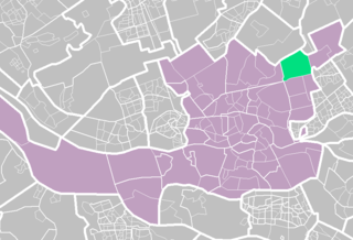
Ommoord is a neighbourhood in the former borough Prins Alexander, part of the municipality of Rotterdam, South Holland, the Netherlands. Ommoord is surrounded by the neighbourhoods Zevenkamp, Het Lage Land and Terbregge. It has around 25.000 inhabitants across 12.500 households.
Mbieri is a town in southeastern Nigeria. It is named after one of the indigenous Igbo clans that conquered parts of the old Owerri province. Mbieri is in Mbaitoli council of Imo State and it is the biggest of the original nine towns of Mbaitoli. The region surrounding Mbieri is rich in hydrocarbons.
Amatta is an autonomous community in Imo State south eastern Nigeria. It is located about 4 km northeast of Owerri.
Superior Bay is a narrow inlet of Lake Superior along the border of Minnesota and Wisconsin. It is seven miles (11 km) long and 0.5 miles (0.8 km) wide. A small strait connects it to the Saint Louis Bay to the west, into which the Saint Louis River empties. Superior Bay is located between the city of Superior and the Park Point neighborhood of Duluth. The Duluth Harbor Basin is nearby.
Ahiara is a city in Mbaise, Imo State, Nigeria. The city stands about 16 miles between Owere and Umuahia. It was the location of Chukwuemeka Odumegwu Ojukwu's Ahiara Declaration during the Nigerian Civil War. It is the location of the Catholic diocese in Mbaise. The first recorded Ahiara contact with the Europeans was around 1905 when the British Aro expedition got mixed up in inter-village war which eventually had Dr. Steward a victim, as a consequence the Ahiara people were severely punished by the British forces with an invasion which forced many citizens to flee and never return.
The Rocky River is a 50.3-mile-long (81.0 km) tributary of the Savannah River in the U.S. state of South Carolina. It flows into the Savannah River just west of Calhoun Falls at 34°05′28″N82°38′25″W. It forms as the confluence of Beaverdam Creek and Little Beaverdam Creek northeast of Anderson at 34°34′13″N82°33′02″W.
The Baby Islands are a group of small islands located about 1.2 miles (1.9 km) northeast of Unalga Island in the Fox Islands group of the Aleutian Islands of southwestern Alaska. The group consists of five islands ranging from 980 to 3280 feet long and several smaller islets. The islands are uninhabited and none of them rise more than a few metres above sea level. Large numbers of birds, notably the whiskered auklet, nest on the islands, making them a frequent stop for nature tours in the area. However, the ocean near the islands is extremely hazardous for ships because of the shallow water and numerous rocks that lie just below water's surface.
Kowalewice is a village in Gmina Miastko, Bytów County, Pomeranian Voivodeship, in northern Poland, on the border with West Pomeranian Voivodeship. It lies approximately 34 kilometres (21 mi) south-west of Bytów and 112 km (70 mi) south-west of Gdańsk.
Prądocinek is a village in the administrative district of Gmina Bobrowice, within Krosno Odrzańskie County, Lubusz Voivodeship, in western Poland. It lies approximately 5 kilometres (3 mi) north of Bobrowice, 6 km (4 mi) south-west of Krosno Odrzańskie, and 31 km (19 mi) west of Zielona Góra.
Stanisławka is a village in the administrative district of Gmina Debrzno, within Człuchów County, Pomeranian Voivodeship, in northern Poland. It lies approximately 5 kilometres (3 mi) north-west of Debrzno, 17 km (11 mi) south-west of Człuchów, and 132 km (82 mi) south-west of the regional capital Gdańsk.

Wiklino is a village in the administrative district of Gmina Słupsk, within Słupsk County, Pomeranian Voivodeship, in northern Poland. It lies approximately 12 kilometres (7 mi) north-east of Słupsk (Stolp) and 99 km (62 mi) west of the regional capital Gdańsk (Danzig).
Kassa (Ká:dà) is a commune of the Cercle of Koro in the Mopti Region of Mali. Tommo So is spoken in Kassa. Kassa consists of a cluster of about 17 villages, mostly situated on the top of a plateau. The principal village lies at Berdosso. In 1998 the commune had a population of 11,218.
Kędrzyno is a village in the administrative district of Gmina Siemyśl, within Kołobrzeg County, West Pomeranian Voivodeship, in north-western Poland. It lies approximately 7 kilometres (4 mi) north-west of Siemyśl, 14 km (9 mi) south-west of Kołobrzeg, and 93 km (58 mi) north-east of the regional capital Szczecin.
Sulechówko is a village in the administrative district of Gmina Malechowo, within Sławno County, West Pomeranian Voivodeship, in north-western Poland. It lies approximately 5 kilometres (3 mi) south-east of Malechowo, 14 km (9 mi) south-west of Sławno, and 161 km (100 mi) north-east of the regional capital Szczecin.
Obazu in Imo State is one of the autonomous communities in Mbieri ancient kingdom of Imo state. It is made up of six villages, namely: Umueze, Umuchoke, Umuchimanwiri, Amaogwugwu, Obilubi and Umunkwo in order of seniority. It is located at the eastern part of Mbieri and share boundaries with Umuoba, Orji and Owuala of Uratta people, Amatta and Akabo (Ikeduru) and Ụmụneke, Umunjam, Amaulu, Eziome, Achi, Umuagwu, Ubakuru and Amankuta. The people are mostly Anglican though there are other Christian denomination followers among her people.
Château d'Autet is a château located in the Luberon hills of the commune of Viens in the Vaucluse department, Provence-Alpes-Côte d'Azur, France. The château lies approximately 3 kilometres (1.9 mi) to the northeast of the village of Gignac, and roughly 85 kilometres (53 mi) north of Marseille. Built in the 19th century as a hunting lodge, the dilapidated house and surrounding neglected estate was bought in 1998 by David Armstrong-Jones, 2nd Earl of Snowdon, who is reported to have paid £500,000. In addition to repairing the house, the Earl planted fields of lavender on the estate nearby.

Glogovo Passage is the 110 metre wide passage between Zverino Island on the west-southwest and Cave Island on the east-northeast in the Meade group off Archar Peninsula, the northwest extremity of Greenwich Island in the South Shetland Islands, Antarctica.
Garwood is an unincorporated community in southern Reynolds County, in the U.S. state of Missouri. The community is on Missouri Route 34 and approximately eight miles northeast of Van Buren in adjacent Carter County.
Tobias is an unincorporated community in Scott Township, Marion County, Ohio, United States. It is located northeast of Marion at the intersection of Tobias Road and Morral-Kirkpatrick Road, at 40°41′18″N83°03′59″W.