Alouette 1

Last updated

Alouette 1
Alouette 1.jpg
The Alouette 1 satellite
Mission typeIonospheric
Operator DRDC
Harvard designation1962 Beta Alpha 1
COSPAR ID 1962-049A OOjs UI icon edit-ltr-progressive.svg
SATCAT no. 424
Mission durationFinal: 10 years and 1 day
Spacecraft properties
Manufacturer Defence Research Telecommunications Establishment
Launch mass145.6 kilograms (321 lb)
Start of mission
Launch dateSeptember 29, 1962, 06:05 (1962-09-29UTC06:05Z) UTC
Rocket Thor DM-21 Agena-B
Launch site Vandenberg LC-75-1-1
End of mission
DeactivatedSeptember 30, 1972 (1972-10-01)
Orbital parameters
Reference system Geocentric
Regime Low Earth
Semi-major axis 7,381 kilometres (4,586 mi) [1]
Eccentricity 0.00243 [2]
Perigee altitude 996 kilometres (619 mi) [2]
Apogee altitude 1,032 kilometres (641 mi) [2]
Inclination 80.500 degrees [2]
Period 105.50 minutes [2]
Epoch 29 September 1962 06:05:00 UTC [2]
 

Alouette 1 is a deactivated Canadian satellite that studied the ionosphere. Launched in 1962, it was Canada's first satellite, and the first satellite constructed by a country other than the Soviet Union or the United States. Canada was the fourth country to operate a satellite, as the British Ariel 1 , constructed in the United States by NASA, preceded Alouette 1 by five months. [3] The name "Alouette" came from the French for "skylark" [4] and the French-Canadian folk song of the same name.

Contents

A key device on Alouette were the radio antennas consisting of thin strips of beryllium copper bent into a slight U-shape and then rolled up into small disks in a fashion similar to a measuring tape. When triggered, the rotation of the satellite created enough centrifugal force to pull the disk away from the spacecraft body, and the shaping of the metal caused it to unwind into a long spiral. The result was a stiff circular cross-section antenna known as a "STEM", for "storable tubular extendible member". [5]

Development

Alouette 1 was part of a joint Canada-U.S. scientific program. [6] Its purpose was to investigate the properties of the top of the ionosphere, and the dependence of those properties on geographical location, season, and time of day. [7] Alouette 1 was advanced for its time, and NASA initially doubted whether the available technology would be sufficient. Nevertheless, NASA was eager to collaborate with international partners. [8] NASA was convinced to participate by the prospect of obtaining data on the ionosphere, and Canada had the additional objective of developing its own space research programme. [8] The United Kingdom also aided the mission by providing support at two ground stations, in Singapore and at Winkfield. [9]

Experiments

Alouette 1 carried four scientific experiments:

The satellite did not have a tape recorder to store data. [14] It was only possible to obtain data when the satellite was in range of a receiving station. [15]

Duplicate construction

Two satellites were built for redundancy in case of a malfunction; if the first unit failed, the second could be launched with only a couple of months delay. It took 3½ years after Alouette's proposal to have it developed and built. [16] The satellites S27-2 (prototype), S27-3 (which became the launched satellite), and S27-4 (which became the backup) were assembled by Defence Research Telecommunications Establishment (DRTE) Electronics Lab in Ottawa, Ontario. The mechanical frame and the deployable STEM antennas were made by Special Products and Applied Research Aerospace (SPAR Aerospace), a former division of de Havilland Canada (DHC) in North York, Ontario, in a building which many years later (until 2012) housed the Canadian Air and Space Museum. The batteries used for Alouette were developed by the Defence Chemical, Biological, and Radiation Laboratory (DCBRL), another branch of DRB, and were partially responsible for the long lifetime of the satellite. The "Storable Tubular Extendable Member" antennas used were the first of DHC's STEM antennas used in space, and at launch were the longest (150 feet tip to tip). [17] Companies such as RCA Victor and Spar Aerospace Limited produced some of their first pieces of space equipment for the Alouette 1 project. [18] Parts used for the construction of Alouette 1 can still be found in the Musée des ondes Emile Berliner in Montreal, Quebec where part of the satellite was worked on. [19]

Satellite launch and mission progress
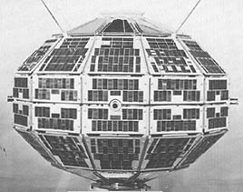
Alouette 1 was launched via Thor-Agena-B two-stage rocket [20] by NASA from the Pacific Missile Range at Vandenberg Air Force Base, California, USA at 06:05 UTC on September 29, 1962, into orbit around Earth. The 145.6 kilograms (321 lb) satellite [21] was placed into an almost circular orbit with an altitude of 987 kilometres (613 mi) to 1,022 kilometres (635 mi) with an inclination of 80.5°. [22] The launch made Canada the third nation, after the USSR and the United States, to design and construct its own satellite. [23] Alouette was used to study the ionosphere, using over 700 different radio frequencies to investigate its properties from above. [24]

The satellite was initially spin-stabilized, rotating 1.4 times per minute. After about 500 days, the rotation had slowed to about 0.6 rpm and the spin-stabilization failed at this point. It was then possible to determine the satellite's orientation only by readings from a magnetometer and from temperature sensors on the upper and lower heat shields. [14] The orientation determinations obtained this way were only accurate to within 10 degrees. It is likely that gravitational gradients had caused the longest antenna to point towards the Earth. [15]

A 2010 technical report by the US Defense Threat Reduction Agency titled "Collateral Damage to Satellites from an EMP Attack" [25] lists Alouette 1 among the satellites damaged by residual radiation from the July 9, 1962, Starfish Prime high-altitude nuclear test conducted by the United States. Another article, titled "Anthropogenic Space Weather", [26] indicates Alouette 1 sustained no significant adverse effects from the Starfish radiation, most likely due to a very conservative power supply design that allowed for a 40% degradation of solar cell performance.

Alouette's mission lasted for 10 years before the satellite was deliberately switched off on September 30, 1972. [27] The satellite remains in orbit; in 1966 it was estimated that Alouette 1 would remain in orbit for 1000 years. [28]

Post mission

After Alouette 1 was launched, the upper stage of the rocket used to launch the satellite became a derelict object that would continue to orbit Earth for many years. As of 2022, the upper stage remains in orbit. [29]

The satellite itself became a derelict, remaining in Earth orbit As of 2022. [30]

The Alouette 1 was named an IEEE Milestone in 1993. [31] It is featured on the Amory Adventure Award.

Alouette 1's backup was later launched, with some modification, as Alouette 2 in 1965 to "replace" the older Alouette 1. [32]

See also

Related Research Articles

<span class="mw-page-title-main">Ionosphere</span> Ionized part of Earths upper atmosphere

The ionosphere is the ionized part of the upper atmosphere of Earth, from about 48 km (30 mi) to 965 km (600 mi) above sea level, a region that includes the thermosphere and parts of the mesosphere and exosphere. The ionosphere is ionized by solar radiation. It plays an important role in atmospheric electricity and forms the inner edge of the magnetosphere. It has practical importance because, among other functions, it influences radio propagation to distant places on Earth. It also affects GPS signals that travel through this layer.

<span class="mw-page-title-main">Communications satellite</span> Artificial satellite that relays radio signals

A communications satellite is an artificial satellite that relays and amplifies radio telecommunication signals via a transponder; it creates a communication channel between a source transmitter and a receiver at different locations on Earth. Communications satellites are used for television, telephone, radio, internet, and military applications. Many communications satellites are in geostationary orbit 22,300 miles (35,900 km) above the equator, so that the satellite appears stationary at the same point in the sky; therefore the satellite dish antennas of ground stations can be aimed permanently at that spot and do not have to move to track the satellite. Others form satellite constellations in low Earth orbit, where antennas on the ground have to follow the position of the satellites and switch between satellites frequently.

<span class="mw-page-title-main">Transit (satellite)</span> Satellite navigation system

The Transit system, also known as NAVSAT or NNSS, was the first satellite navigation system to be used operationally. The radio navigation system was primarily used by the U.S. Navy to provide accurate location information to its Polaris ballistic missile submarines, and it was also used as a navigation system by the Navy's surface ships, as well as for hydrographic survey and geodetic surveying. Transit provided continuous navigation satellite service from 1964, initially for Polaris submarines and later for civilian use as well. In the Project DAMP Program, the missile tracking ship USAS American Mariner also used data from the satellite for precise ship's location information prior to positioning its tracking radars.

<span class="mw-page-title-main">Very low frequency</span> The range 3–30 kHz of the electromagnetic spectrum

Very low frequency or VLF is the ITU designation for radio frequencies (RF) in the range of 3–30 kHz, corresponding to wavelengths from 100 to 10 km, respectively. The band is also known as the myriameter band or myriameter wave as the wavelengths range from one to ten myriameters. Due to its limited bandwidth, audio (voice) transmission is highly impractical in this band, and therefore only low data rate coded signals are used. The VLF band is used for a few radio navigation services, government time radio stations and for secure military communication. Since VLF waves can penetrate at least 40 meters (131 ft) into saltwater, they are used for military communication with submarines.

<span class="mw-page-title-main">Whistler (radio)</span> Very low frequency EM waves generated by lightning

A whistler is a very low frequency (VLF) electromagnetic (radio) wave generated by lightning. Frequencies of terrestrial whistlers are 1 kHz to 30 kHz, with maximum frequencies usually at 3 kHz to 5 kHz. Although they are electromagnetic waves, they occur at audio frequencies, and can be converted to audio using a suitable receiver. They are produced by lightning strikes where the impulse travels along the Earth's magnetic field lines from one hemisphere to the other. They undergo dispersion of several kHz due to the slower velocity of the lower frequencies through the plasma environments of the ionosphere and magnetosphere. Thus they are perceived as a descending tone which can last for a few seconds. The study of whistlers categorizes them into Pure Note, Diffuse, 2-Hop, and Echo Train types.

Radio propagation is the behavior of radio waves as they travel, or are propagated, from one point to another in vacuum, or into various parts of the atmosphere. As a form of electromagnetic radiation, like light waves, radio waves are affected by the phenomena of reflection, refraction, diffraction, absorption, polarization, and scattering. Understanding the effects of varying conditions on radio propagation has many practical applications, from choosing frequencies for amateur radio communications, international shortwave broadcasters, to designing reliable mobile telephone systems, to radio navigation, to operation of radar systems.

<span class="mw-page-title-main">Extremely low frequency</span> The range 3-30 Hz of the electromagnetic spectrum

Extremely low frequency (ELF) is the ITU designation for electromagnetic radiation with frequencies from 3 to 30 Hz, and corresponding wavelengths of 100,000 to 10,000 kilometers, respectively. In atmospheric science, an alternative definition is usually given, from 3 Hz to 3 kHz. In the related magnetosphere science, the lower frequency electromagnetic oscillations are considered to lie in the ULF range, which is thus also defined differently from the ITU radio bands.

<span class="mw-page-title-main">Project Echo</span> First passive communications satellite experiment

Project Echo was the first passive communications satellite experiment. Each of the two American spacecraft, launched in 1960 and 1964, were metalized balloon satellites acting as passive reflectors of microwave signals. Communication signals were transmitted from one location on Earth and bounced off the surface of the satellite to another Earth location.

<span class="mw-page-title-main">Orbiting Geophysical Observatory</span>

Orbiting Geophysical Observatory (OGO) Program of NASA refers to the six satellites launched by the United States that were in use from September 1964 to 1972, designed to study the Earth's magnetosphere. The satellites successfully studied the interactions between the Earth and the Sun, despite a number of technical problems. Each satellite had 20 to 25 instruments. OGO 1, OGO 3, and OGO 5 were in equatorial orbits; OGO 2, OGO 4, and OGO 6 were in lower polar orbits.

<span class="mw-page-title-main">ATS-6</span> NASA experimental satellite

ATS-6 was a NASA experimental satellite, built by Fairchild Space and Electronics Division It has been called the world's first educational satellite as well as world's first experimental Direct Broadcast Satellite as part of the Satellite Instructional Television Experiment between NASA and Indian Space Research Organisation (ISRO). It was launched May 30, 1974, and decommissioned July 1979. At the time of launch, it was the most powerful telecommunication satellite in orbit. ATS-6 carried no fewer than 23 different experiments, and introduced several breakthroughs. It was the first 3-axis stabilized spacecraft in geostationary orbit. It was also the first to use experimentally with some success electric propulsion in geostationary orbit. It also carried several particle physics experiments, including the first heavy ion detector in geostationary orbit.

<span class="mw-page-title-main">Astérix (satellite)</span> First French satellite

Astérix or A-1 is the first French satellite. It was launched on 26 November 1965 by a Diamant A rocket from the CIEES launch site at Hammaguir, Algeria. With Astérix, France became the sixth country to have an artificial satellite and the third country to launch a satellite on its own rocket. Its main purpose was to test the Diamant launcher, though it was also designed to study the ionosphere. Astérix continues to orbit Earth as of 2023 and is expected to remain in orbit for centuries.

<span class="mw-page-title-main">Explorer 52</span> NASA satellite of the Explorer program

Explorer 52, also known as Hawkeye-1, Injun-F, Neutral Point Explorer, IE-D, Ionospheric Explorer-D, was a NASA satellite launched on 3 June 1974, from Vandenberg Air Force Base on a Scout E-1 launch vehicle.

<span class="mw-page-title-main">Plasmasphere</span> Region of Earths magnetosphere consisting of cool plasma

The plasmasphere, or inner magnetosphere, is a region of the Earth's magnetosphere consisting of low-energy (cool) plasma. It is located above the ionosphere. The outer boundary of the plasmasphere is known as the plasmapause, which is defined by an order of magnitude drop in plasma density. In 1963 American scientist Don Carpenter and Soviet astronomer Konstantin Gringauz proved the plasmasphere and plasmapause's existence from the analysis of very low frequency (VLF) whistler wave data. Traditionally, the plasmasphere has been regarded as a well behaved cold plasma with particle motion dominated entirely by the geomagnetic field and, hence, co-rotating with the Earth.

<span class="mw-page-title-main">Project West Ford</span> Experimental space-based radio communication project

Project West Ford was a test carried out by Massachusetts Institute of Technology's Lincoln Laboratory on behalf of the United States military in 1961 and 1963 to create an artificial ionosphere above the Earth. This was done to solve a major weakness that had been identified in military communications.

James R. Wait was a Canadian electrical engineer and engineering physicist. In 1977, he was elected as a member of National Academy of Engineering in Electronics, Communication & Information Systems Engineering for his contributions to electromagnetic propagation engineering as it affects communication and geophysical exploration.

<span class="mw-page-title-main">Ariel 2</span>

Ariel 2, also known as UK-C, was a British radio astronomy satellite, which was operated by the Science and Engineering Research Council as part of the Ariel programme. It was built in America by Westinghouse Electric, and had a mass at launch of 68 kilograms (150 lb). It was launched in 1964, and became the first satellite to be used for radio astronomy, although the Canadian satellite Alouette 1 was launched 1962 and also did similar radio astronomy observations.

<span class="mw-page-title-main">Telstar</span> Name of various communications satellites

Telstar is the name of various communications satellites. The first two Telstar satellites were experimental and nearly identical. Telstar 1 launched on top of a Thor-Delta rocket on July 10, 1962. It successfully relayed through space the first television pictures, telephone calls, and telegraph images, and provided the first live transatlantic television feed. Telstar 2 was launched May 7, 1963. Telstar 1 and 2—though no longer functional—still orbit the Earth.

<span class="mw-page-title-main">FR-1 (satellite)</span> French scientific satellite; the second French satellite

FR-1 was the second French satellite. Planned as the first French satellite, it was launched on 6 December 1965—ten days after the actual first French satellite, Astérix—by an American Scout X-4 rocket from the Western Range at Vandenberg Air Force Base. The scientific satellite studied the composition and structure of the ionosphere, plasmasphere, and magnetosphere by measuring the propagation of very low frequency (VLF) waves and the electron density of plasma in those portions of the Earth's atmosphere. FR-1's VLF receiver operated until 26 August 1968. FR-1 remains in orbit as of 2023.

Llewelyn Robert Owen Storey is a British physicist and electrical engineer who has worked and lived most of his adult life in France. He is known for his research on the Earth's atmosphere, especially whistlers—very low frequency (VLF) radio waves caused by lightning strikes—and the plasmasphere. He was the first person to prove whistlers are caused by lightning strikes and to deduce the plasmasphere's existence. He was heavily involved in designing scientific instruments for FR-1, a 1965 French-American satellite, and subsequent studies and experiments using data FR-1 collected.

<span class="mw-page-title-main">Sainte-Assise transmitter</span> Radio transmitter in France

The Sainte-Assise transmitter is a very low frequency (VLF) radio transmitter and military installation located on the grounds of the Château de Sainte-Assise in the communes of Seine-Port, Boissise-la-Bertrand, and Cesson in the Seine-et-Marne department of the Île-de-France region of France. The transmitter's original equipment was inaugurated on 9 January 1921, at the time being the most powerful radio transmitter on Earth. On 26 November 1921 the first French radio program was transmitted from Sainte-Assise. In 1965 the transmitter was used to send VLF signals to FR-1, the first French satellite. Since 1998 the French Navy has used the transmitter to communicate with submerged submarines.

References

  1. "ALOUETTE 1 (S-27)". N2YO.com. April 26, 2016. Retrieved April 26, 2016.
  2. 1 2 3 4 5 6 "Alouette 1 – Trajectory Information". NASA NSSDCA. Retrieved January 1, 2023.
  3. Palimaka, John. "The 30th Anniversary of Alouette I". IEEE. Archived from the original on March 3, 2016. Retrieved April 18, 2014.
  4. Helen T. Wells; Susan H. Whiteley; Carrie E. Karegeannes. Origin of NASA Names. NASA Science and Technical Information Office. p. 10.
  5. "Antenna material". Ingenium. Retrieved July 23, 2018.
  6. Houghton, J. T.; Taylor, F. W.; Rodgers, C. D. (March 27, 1986), Remote Sounding of Atmospheres, Cambridge Planetary Science Series, vol. 5, Cambridge University Press, p. 234, ISBN   0521310652
  7. 1 2 3 Kramer, Herbert J. (2002). Observation of the Earth and its Environment: Survey of Missions and Sensors (4 ed.). Berlin: Springer. p. 50. ISBN   3540423885.
  8. 1 2 Rakobowchuk, Peter (September 8, 2012), "NASA once thought Canada's famed Alouette-1 satellite was too ambitious: space engineer", National Post , retrieved May 1, 2015
  9. Le Galley, Donald P. (1964), "1", in Le Galley, Donald P.; Rosen, Alan (eds.), Space Physics, Univer1sity of California Engineering and Physical Sciences Extension Series, John Wiley and Sons, p. 36
  10. "Sweep-Frequency Sounder". NASA. August 26, 2014. Retrieved September 30, 2014.
  11. "Energetic Particles Detectors". NASA. August 26, 2014. Retrieved September 30, 2014.
  12. "VLF Receiver". NASA. August 26, 2014. Retrieved September 30, 2014.
  13. "Cosmic Radio Noise". NASA. August 26, 2014. Retrieved September 30, 2014.
  14. 1 2 Angelo, Joseph A. (2006). Encyclopedia of Space and Astronomy. New York: Infobase Publishing. p. 22. ISBN   978-0-8160-5330-8.
  15. 1 2 Grayzeck, Ed (August 26, 2014). "Alouette 1". NASA. Retrieved April 18, 2014.
  16. "Canada: 50 years in space - Canadian Geographic". Archived from the original on July 19, 2012. Retrieved July 6, 2012.
  17. "The Alouette Program". Online Journal of Space Communication. Ohio University. 4. Retrieved January 1, 2023.
  18. Agency, Canadian Space (March 5, 2012). "Satellite Alouette I and II". Canadian Space Agency. Retrieved August 16, 2022.
  19. "Magic of Waves in Saint-Henri". Musée des ondes Emile Berliner. Retrieved August 16, 2022.
  20. McDowell, Jonathan. "Launch Log". Jonathan's Space Report. Retrieved October 11, 2020.
  21. Saxena, Ashok K. (1978), "Appendix 1", in Wertz, James R. (ed.), Spacecraft Attitude Determination and Control, Astrophysics and Space Science Library, vol. 73, Dordrecht, Holland: D. Reidel Publishing Company, pp. 788–789, ISBN   90-277-0959-9
  22. Darling, David (June 3, 2003). The Complete Book of Spaceflight: From Apollo 1 to Zero Gravity. Hoboken, New Jersey: John Wiley & Sons. ISBN   0471056499.
  23. "Alouette I and II". Canadian Space Agency. March 3, 2012.
  24. Gainor, Chris (2012), Alouette 1 – Celebrating 50 Years of Canada in Space, SpaceRef, archived from the original on April 17, 2015
  25. Conrad, Edward E., et al. "Collateral Damage to Satellites from an EMP Attack" Report DTRA-IR-10-22, Defense Threat Reduction Agency. August 2010 (Retrieved May 27, 2019)
  26. T. I. Gombosi., et al. "Anthropogenic Space Weather" Space Science Reviews. 10.1007 (Page 26, Table 2) (Retrieved May 27, 2019)
  27. Baker, David (2004). Jane's Space Directory. Jane's Information Group. p. 471.
  28. "Space trash, and an inventory of hardware in orbit". LIFE. Vol. 61, no. 6. 1966. p. 29.
  29. "Alouette 1 Rocket – Satellite Information". satellite database. Heavens-Above. Retrieved September 25, 2013.
  30. "Alouette 1 – Satellite Information". satellite database. Heavens-Above. Retrieved September 25, 2013.
  31. "Milestones:Alouette-ISIS Satellite Program, 1962". IEEE Global History Network. IEEE. Retrieved July 29, 2011.
  32. "The ISIS Satellite Program". friendsofcrc.ca. July 19, 1996. Retrieved February 26, 2017.