Anaheim Island, California

Last updated

Anaheim Island, Orange County, California
USA California location map.svg
Red pog.svg
Anaheim Island, Orange County, California
Usa edcp location map.svg
Red pog.svg
Anaheim Island, Orange County, California
Coordinates: 33°48′50.5″N117°57′49.56″W / 33.814028°N 117.9637667°W / 33.814028; -117.9637667
Country United States
State California
County Orange
Elevation
157 ft (48 m)
Population
 (1990)
  Total6,800
Time zone UTC-8 (PST)
  Summer (DST) UTC-7 (PDT)
ZIP Code
92804
Area code 714

Anaheim Island (also known as Anaheim West, Southwest Anaheim, and Garza Island) consists of several unincorporated neighborhoods located east of the city of Anaheim in Orange County, California, United States. Established between the 1910s and 1960s, the neighborhoods are bounded by the cities of Anaheim to the east, north and west, Stanton to the southwest, and Garden Grove to the south. The Orange County Board of Supervisors has referred to these unincorporated areas as "Anaheim Island" [1] while Orange County LAFCO has referred to them variously as "Anaheim West" [2] and "Southwest Anaheim". [3] The Anaheim City Planning Commission refers to the entire area in the singular as the "Garza Island". [4] [5] Some local residents refer to the area as the "Gaza Strip". [6]

Contents

History

After World War II, Orange County experienced dramatic growth, the formation of many new municipalities, and the expansion of existing municipalities through annexation of neighboring county territory. [7] With economic development driving expansion, cities sought to annex prosperous neighborhoods and commercial districts; neighborhoods that were less prosperous, neighborhoods with older housing stock and large families drawn by its affordability, and neighborhoods largely populated by Mexicans found themselves bypassed by city governments reluctant to provide services to aging residential districts, or to increase their minority population. [8] Cities set their sights on the most economically productive or promising county territory; in turn, many residents of unincorporated areas resisted potential tax increases, sought to preserve community identity, and sought to preserve perceived (and often disputed) advantages of their neighborhoods' unincorporated status. Thus was born the phenomenon of the county island, either partially or wholly surrounded by municipal territory. [9] [10]

Since the 1960s, the unincorporated neighborhoods of west Orange County that fall within Anaheim's sphere of influence have been colloquially called the "Gaza Strip" [6] or, more recently, the "Garza Strip". [11] [12] [13] [14] [15] [16] Both nicknames allude to Garza Avenue, the area's oldest and southernmost street; the area's strip-like shape; and its popularity as a dragstrip frequented by scofflaws cognizant of the county sheriff's jurisdiction and delays in response to complaints to law enforcement resulting from the distance sheriffs must travel to reach the area. [17] Additionally, the word "Gaza" alludes to the area's unincorporated status, similar to that of the Gaza Strip of the Palestinian territories.

The mid-1990s witnessed an influx of Middle Eastern immigrants into west Anaheim, with many businesses serving the Arab American population established on a stretch of Brookhurst Street adjacent to the unincorporated areas. This migration has earned the commercial district the nickname Little Gaza, which conflates the unincorporated area's "Gaza Strip" nickname with the "Little (place name)" naming convention for ethnic enclaves. [18] [19] Although "Gaza Strip" is also occasionally used to describe the Brookhurst Street corridor, [20] [21] the term predates the arrival of significant numbers of Middle Eastern immigrants to the area.

A local urban legend has it that a fire once broke out in one of the unincorporated areas near an Anaheim city fire station, and that firemen on duty witnessed the fire but allowed the structure to burn since it was not within their jurisdiction.[ citation needed ] Although the story's veracity is questionable, its existence is generally indicative of the disputes that have often arisen between residents of unincorporated, marginalized neighborhoods in urbanized areas and the cities that surround them.

Neighborhoods

Anaheim Island includes several discrete neighborhoods. Most of the homes in the area, except for those in La Colonia Independencia (see below), were built in the early 1950s, spurred by the construction and opening of Disneyland. [22] A 2008 survey of residents found that approximately 25% of Anaheim Island homes are in need of rehabilitation. [23] Low-income first-time homebuyers purchasing in the area are entitled to receive down payment assistance loans through the County of Orange Mortgage Assistance Program. [24]

Demographic information cited below is drawn from the Orange County 2005-2010 Consolidated Plan, which cites 1990 United States Census statistics, gathered prior to the arrival of significant numbers of Middle Eastern immigrants. [25]

La Colonia Independencia

La Colonia Independencia consists of approximately 30 acres (120,000 m2) of residential land, 1.8 acres (7,300 m2) of school maintenance yard, and less than 1 acre (4,000 m2) of community center and parkland. The neighborhood is bounded by Katella Avenue on the south and Pacific Place (south of the Union Pacific Railroad tracks) on the north, between which run Garza, Berry and Harcourt Avenues. The neighborhood contains 101 single-family homes. [26] La Colonia has approximately 1,700 residents, one-third of whom are children. 66% of its residents are Hispanic, 17% are white, 11% are of Asian/Pacific Island descent, and 4% are black. [25] Many families have lived in the neighborhood for generations, and residents express a strong sense of ethnic and community pride. [27] [28] [29] [30] [31] [32] [33] [34]

Originally a "citrus camp" established by Mexican farm laborers at the edge of a now-defunct orange grove, La Colonia Independencia ranks with El Modena as one of the oldest surviving barrios in Orange County. [6] The community was born after the United States' entry into World War I, when relaxation of immigration restrictions spurred by the citrus industry's demand for cheap labor drew thousands of Mexican men and their families to the United States, where they made their homes in segregated communities near the railroad tracks that ran through the groves. Misión del Sagrado Corazón, La Colonia's Catholic church, was built in 1926; [35] Magnolia School No. 2 was established shortly thereafter on Garza Street, and was attended exclusively by Mexican students. In spite of the 1946 decision in Mendez v. Westminster outlawing racial and language-based segregation in California schools, and in spite of then-Governor Earl Warren's subsequent repeal of provisions of the California Education Code that allowed segregation in the state's public schools, Magnolia School No. 2 continued to operate until 1954, when community activist Gloria Lopez challenged the district to transfer white children into the barrio school rather than build a new one. [36] In the face of protests from white parents, Magnolia School No. 2 was closed and replaced with a school bus warehouse. As late as the 1970s, the community had no paved streets, sidewalks or sewers. [37] In 2001, the need to remedy public neglect of the area and address an increase in gang-related crime [38] [39] led county supervisors to secure federal funding for increased community services in La Colonia and the adjacent Southwest Anaheim neighborhood. [40] [41] [42] [43] [44]

West Island

West Anaheim Island occupies approximately 187 acres (0.76 km2) and contains 1,026 homes. Many of its streets bear Louisiana place-names (e.g., Bienville, Gravier, Antigua, and Perdido). The district is bounded by Ball Road to the north, by the Union Pacific Railroad tracks south of Pacific Avenue to the south, and by Brookhurst Street and Gilbert Street to the east and west. The district also includes a tract of homes at the southwest corner of Cerritos Avenue and Gilbert Street, as well as an adjacent row of homes along the south side of Pacific Avenue, immediately north of the tracks. [45] 50% of West Anaheim Island's residents are Hispanic, 27% white, 16% Asian/Pacific Islanders (23%), and 4% black. [25]

The West Island Neighbors Group was established after the city of Anaheim's announcement of its plans to annex the area (see below). [46] The organization publishes a newsletter, the West Island Breeze, which is distributed to community residents.

Southwest Anaheim

Southwest Anaheim (identified as "Anaheim Island" on the Orange County Development Agency's map of the area [47] ) is an entirely residential neighborhood near the northeast corner of Katella Avenue and Gilbert Street, south of the tracks from West Anaheim and adjacent to La Colonia Independencia. The 171-home development (originally called "House and Garden Homes") was built by Tobin Developers in 1955 on approximately 29 acres (120,000 m2) of residential land. [6] [47] 60% of Southwest Anaheim's residents are Hispanic, 23% are Asian/Pacific Islanders, and 17% are white. [25]

Sherwood Forest and Thistle development

Sherwood Forest is a development of 406 homes built in 1955, occupying approximately 95 acres (380,000 m2) of residential land bounded by Brookhurst Street and Gilbert Street to the east and west, and by Orange Avenue and Ball Road to the north and south. [48] 39% of Sherwood Forest's residents are white, 31% Hispanic, 24% Asian/Pacific Islanders, and 4% black. [25] Adjacent to Sherwood Forest and located between Orange Avenue and Broadway is the distinct, also unincorporated, 88-parcel Thistle development. [49] [50]

For purposes of community planning and needs assessment, the Orange County Board of Supervisors groups two additional, non-contiguous county islands bounded only by Stanton and Garden Grove with those adjacent to Anaheim, due to their proximity. [25] These two islands are not, however, included in the city of Anaheim's annexation proposals (see below).

Rustic Lane

The Rustic Lane neighborhood is located north of Katella Avenue between Gilbert Street and Magnolia Avenue. [51] The 9-acre (36,000 m2) district houses 1,736 people in 347 housing units. 66% of Rustic Lane's residents are Hispanic, 17% white, 11% Asian/Pacific Islanders, and 4% black. [25]

Mac Island

Mac Island contains 116 single-family homes occupying approximately eighteen acres of land near the northwest corner of Katella and Magnolia Avenues. [52] 62% of the neighborhood's 441 residents are white, 17% are Hispanic, and 17% Asian/Pacific Islanders. [25]

Education

Anaheim Island students are served by the elementary schools of the Anaheim City School District and the Magnolia School District. The Anaheim Union High School District provides middle schools and high schools for the Anaheim Island.

The Anaheim Public Library and the Stanton branch of the Orange County Public Libraries system both serve Anaheim Island residents.

Public safety

Police protection services in the Anaheim Island neighborhoods are provided by the North Operations Patrol Bureau of the Orange County Sheriff's Department. [53] Traffic enforcement is the responsibility of the California Highway Patrol. Fire protection and emergency services are provided by the Anaheim Fire Department through a contractual agreement with the Orange County Fire Authority.

Annexation controversy

In 1994, Orange County declared the greatest municipal bankruptcy in United States history, the result of a $1.7 billion loss sustained after Treasurer-Tax Collector Robert Citron invested county funds in various risky financial instruments. [54] [55] Since that time, county officials have sought to reduce and eventually eliminate county responsibility for provision of municipal services such as policing, street sweeping, trash removal and building code enforcement, in order to focus greatly diminished county resources on provision of regional services such as public health, social services, flood control, environmental protection and regional planning. [56] One means of achieving this goal has been to encourage municipalities within the county to annex unincorporated areas within or adjacent to their boundaries. [57] [58] [59]

Reduction of the number of unincorporated islands in California municipalities has been an express priority of the California state legislature since the passage of the Cortese-Knox-Hertzberg Local Government Reorganization Act of 2000. The Act establishes procedures for annexations and consolidations of cities or special districts, and delegates responsibility for the process to Local Agency Formation Commissions (LAFCOs). Among the purposes of LAFCOs are the encouragement of the orderly formation, development and consolidation of local agencies and the discouragement of urban sprawl. The Cortese-Knox-Hertzberg Act allows cities to annex areas up to 150 acres (0.61 km2) without a vote by property owners; however, annexation can be blocked by a petition signed by over fifty percent of voters. [60]

In April 2005 the Anaheim City Planning Commission reversed its historic opposition to proposals to annex the "Gaza Strip" [12] and approved a plan newly developed by the Orange County LAFCO. [61] [62] City and county officials and Anaheim Island homeowners who supported the plan contended that annexation would result in increased efficiency in the provision of community services and decreased police response time; that more assiduous building code enforcement would improve residents' quality of life and slow neighborhood blight by reducing the number of illegal garage-to-apartment conversions and substandard repairs, and by motivating property owners - many of them absentee landlords - to adequately maintain deteriorating homes; and that grant-assisted upgrades from septic systems to sewer hookups would increase home values and lessen the potential for groundwater contamination. [16] [63] [64]

After learning of the plan, a group of Anaheim Island residents formed the West Island Neighbors Group and circulated a petition opposing annexation. [65] Opponents of the plan argued that annexation would result in increased taxes and public utility rates, and new municipal fees and permit requirements; that city zoning regulations would prevent residents from keeping farm animals and running kennels; that residents would be inconvenienced by the designation of new street addresses for their homes; that more stringent building code enforcement and requirements for sewer hookups would result in excessive expense to homeowners with limited incomes; and that property might be confiscated for redevelopment. [66] Residents of La Colonia expressed particular concern that annexation would pave the way for the destruction of their neighborhood through gentrification, the fate of old county barrios such as La Conga, razed and replaced with a parking lot for Anaheim's Glover Stadium. [67] [68] [69] Concerned with the prospect of a shrinking patrol area, the Association of Orange County Deputy Sheriffs [70] mailed a flier opposing annexation to area residents. [37] [71] The anti-annexation petition eventually gathered 1,944 signatures, and the plan was defeated in October 2005. [17] [63] [64] [72] [73] [74]

The "Save Our Islands" petition was prepared by an Arlington, Virginia political consulting firm, and thousands of copies were distributed to Anaheim Island residents. However, although the petition included a contact telephone number and address, it lacked a statement regarding the source of financing for the anti-annexation campaign, and did not identify the organization or individuals that sponsored it. [65] In withholding this information, opponents of annexation availed themselves of a loophole in the Cortese-Knox-Hertzberg Act. At the time of the campaign, the statute's campaign finance disclosure requirements specified their applicability to petitions for and against reorganization of municipal boundaries that have reached the ballot stage, but not to protests of proposals by a LAFCO functioning in its capacity as a "conducting authority" responsible for implementing boundary changes and considering citizen feedback. [75]

In January 2006, the Orange County Planning Board resolved to introduce legislation to close the loophole. [76] Following his election to the California State Assembly, former Orange County Supervisor Jim Silva introduced an amendment to the Cortese-Knox-Hertzberg Act mandating disclosure of sponsors, contributions and expenditures for campaigns for and against annexation proposals approved by LAFCOs at any stage of the process. The amendment was approved by unanimous vote of the California legislature, signed into law in July 2008, [77] and further amended in March 2009. [78]

In January 2009, the Orange County LAFCO began to encourage owners of unincorporated property whose lots abut Anaheim city limits to apply for annexation on an individual basis, offering a waiver of the usual $7,900 fee charged for changing a property's jurisdiction from the county to Anaheim. [79] [80] [81] Between January 2009 and May 2010, over 100 Anaheim Island property owners filed annexation applications, 20 pertaining to parcels in the 88-parcel Thistle development. The Orange County LAFCO subsequently proposed to annex the entire Thistle neighborhood to the city of Anaheim; [82] however, a new petition opposing annexation attracted enough signatures to require a special election, which was held August 31, 2010. [83] [84] The annexation measure received a total of 35 "yes" votes and 84 "no" votes, and was therefore defeated. [85]

Related Research Articles

<span class="mw-page-title-main">Orange County, California</span> County in California, United States

Orange County, often known by its initials O.C., is a county located in the Los Angeles metropolitan area in Southern California, United States. As of the 2020 census, the population was 3,186,989, making it the third-most-populous county in California, the sixth-most-populous in the United States, and more populous than 19 American states and Washington, D.C. Although largely suburban, it is the second-most-densely-populated county in the state behind San Francisco County. The county's three most-populous cities are Anaheim, Santa Ana, and Irvine, each of which has a population exceeding 300,000. Santa Ana is also the county seat. Six cities in Orange County are on the Pacific coast: Seal Beach, Huntington Beach, Newport Beach, Laguna Beach, Dana Point, and San Clemente.

<span class="mw-page-title-main">Anaheim, California</span> City in the United States

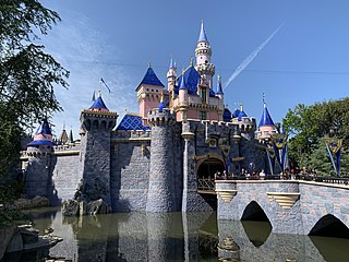
Anaheim is a city in northern Orange County, California, United States, part of the Los Angeles metropolitan area. As of the 2020 United States Census, the city had a population of 346,824, making it the most populous city in Orange County, the 10th-most populous city in California, and the 55th-most populous city in the United States. Anaheim is the second-largest city in Orange County in terms of land area, and is known for being the home of the Disneyland Resort, the Anaheim Convention Center, and two major sports teams: the Los Angeles Angels baseball team and the Anaheim Ducks ice hockey club.

<span class="mw-page-title-main">Orange, California</span> City in California, United States

Orange is a city located in northern Orange County, California. It is approximately 3 miles (4.8 km) north of the county seat, Santa Ana. Orange is unusual in this region because many of the homes in its Old Town District were built before 1920. While many other cities in the region demolished such houses in the 1960s, Orange decided to preserve them. The small city of Villa Park is surrounded by the city of Orange. The population of Orange was 139,911 as of 2020.

<span class="mw-page-title-main">Seal Beach, California</span> City in California, United States

Seal Beach is a coastal city in Orange County, California, United States. As of the 2020 census, the population was 25,242, up from 24,168 at the 2010 census.

<span class="mw-page-title-main">Yorba Linda, California</span> City in California, United States

Yorba Linda is a suburban city in northeastern Orange County, California, United States, approximately 37 miles (60 km) southeast of Downtown Los Angeles. It is part of the Los Angeles metropolitan area, and had a population of 68,336 at the 2020 census.

A county island is a small or large portion of an unincorporated area that is within the jurisdiction of a county, usually surrounded by adjacent areas that are incorporated into a municipality. On maps, these geopolitical anomalies will form jagged or complex borders and 'holes' in the city limits. Generally found more frequently in the western United States, county islands form in areas of expansion when previously smaller cities will annex and incorporate more land into their jurisdiction. If residents or landowners in a particular unincorporated area do not vote to incorporate with the surrounding city, the area remains unincorporated. The formation of a county island usually follows stages where it will come into being on the edge of an incorporated area, and as more territory is incorporated, be cut off from the rest of the unincorporated area within the county. These areas are not actually exclaves by definition, because they are simply unincorporated outside of a surrounding city.

Atwood is a small predominantly Mexican-American neighborhood in Placentia, California. Atwood's unofficial boundaries are defined roughly as the area of Placentia in the square formed by Orangethorpe Avenue, Van Buren Street, Lakeview Road, and Miraloma Avenue. There is a post office in Atwood with a ZIP code of 92811. However, this ZIP code is only used for PO boxes. All non-PO box addresses in Atwood are listed as "Placentia" by the United States Postal Service.

Gaza may refer to:

<span class="mw-page-title-main">Midway City, California</span> Census-designated place in California, United States

Midway City is a census-designated place in the United States that forms part of the county land controlled by Orange County, California. The only area in Orange County that incorporates its chamber of commerce and homeowners association to act in concert like a city council, the area mostly is surrounded by Westminster with Huntington Beach bordering it on the southwest. Midway City was so named because it is horizontally midway between Seal Beach, to the west, and Santa Ana, to the east. The 2010 census listed the population as 8,485.

<span class="mw-page-title-main">Saticoy, California</span> Place in California, United States

Saticoy is an unincorporated community in Ventura County, California, United States. The settlement was laid out in 1887 along the railroad line that was being built from Los Angeles through the Santa Clara River Valley to the town of San Buenaventura. Although the town was 10 miles (16 km) distant at that time, the City of Ventura grew to a point where the community is now just outside the city limits. For statistical purposes, the United States Census Bureau has defined Saticoy as a census-designated place (CDP).

Little Arabia is an ethnic enclave in western Anaheim, California, the center for Orange County's Arab Americans, who number more than 24,000. It has been referred to as "Little Gaza" which was a riff on the nearby Garza Island neighborhoods. Little Arabia grew significantly in the 1990s with the arrival of immigrants from the Middle East, and is the home to thousands of Arab Americans predominantly hailing from Egypt, Syria, Palestine, Lebanon, and Yemen.

Municipal annexation is a process by which a municipality acquires new territory, most commonly by expanding its boundaries into an adjacent unincorporated area. This has been a common response of cities to urbanization in neighboring areas. It may be done because the neighboring urban areas seek municipal services or because a city seeks control over its suburbs or neighboring unincorporated areas.

<span class="mw-page-title-main">Harbor Boulevard</span> North–south road corridor in the counties of Los Angeles and Orange

Harbor Boulevard is a north–south road corridor in the counties of Los Angeles and Orange. One of the busiest routes in Orange County, the thoroughfare passes through some of the most densely populated areas in the region and carries about 8 percent of the county's bus riders. The route provides access for local residents to travel to work and for drivers travelling from Valley Boulevard in the City of Industry via Fullerton Road to Newport Beach.

<span class="mw-page-title-main">Anaheim Hills</span> Planned community in California, United States

Anaheim Hills is a planned community encompassing the eastern portions of the city of Anaheim, in Orange County, California.

West Anaheim is a district in Anaheim, California which extends from Euclid Street on the East to the city limits at Cypress on the West. West Anaheim is where most of the residential development occurred during the 1950s and the 1960s, after Disneyland opened in 1955.

<span class="mw-page-title-main">Anaheim Regional Transportation Intermodal Center</span> Passenger train and bus station in California, United States

The Anaheim Regional Transportation Intermodal Center (ARTIC) is an intermodal transit center in Anaheim, California, United States. It serves as a train station for Amtrak intercity rail and Metrolink commuter rail, as well as a bus station used by the Orange County Transportation Authority (OCTA), Anaheim Resort Transportation (ART), Greyhound, Megabus, Flixbus and Tres Estrellas de Oro.

<span class="mw-page-title-main">Rossmoor, California</span> Census-designated place in California, United States

Rossmoor is a planned census-designated place located in Orange County, California. As of the 2020 census, the CDP had a total population of 10,625 up from the 2010 census population of 10,244. The gated Leisure World retirement community in the city of Seal Beach is to the south of Rossmoor, Los Alamitos is to the east and north, and Long Beach is to the west. The community of Rossmoor has two shopping centers within its boundaries, but only one—the Rossmoor Village Square, is now within the political boundaries of Rossmoor. A larger shopping center, the Rossmoor Business Center, was annexed, despite many protests, by the City of Seal Beach in 1967. The Center has been remodeled several times and was renamed the Shops at Rossmoor in the early 2000s.

<span class="mw-page-title-main">Valencia, California</span> Community in Los Angeles County, California, United States

Valencia is an unincorporated community in northwestern Los Angeles County, California. This area, with major commercial and industrial parks, straddles State Route 126 and the Santa Clara River.

The Orange County Local Agency Formation Commission, or OC LAFCO, is a government agency that makes decisions regarding boundaries for cities, unincorporated territory and special districts within Orange County, California. Orange County LAFCO offices are located in Santa Ana, California.

The Anaheim police shootings and protests of July 2012 involve two fatal shootings by police officers in Anaheim, California, and subsequent public protests. On July 21, Manuel Diaz was shot and killed by Anaheim Police officer Nick Bennallack after he ran from the officers. Protests ensued after the shooting. On July 22, Joel Acevedo was shot and killed by Anaheim police in an alleged exchange of gunfire, making the seventh fatal shooting by an officer in Anaheim in twelve months. Both shootings were ruled justified by the Orange County District Attorney's Office, but a federal jury later found Officer Bennallack guilty of excessive force.

References

  1. Orange County Planning Commission (14 September 1993). "Orange County Environmental Management Agency: Housing Element, Advance Planning Program". Archived from the original on 15 June 2009. Retrieved 28 May 2009.
  2. Orange County Local Agency Formation Commission (July 8, 2008). "Map: City of Anaheim Unincorporated County Island" (PDF). Retrieved May 28, 2009.[ permanent dead link ]
  3. Orange County Local Agency Formation Commission. "Southwest Anaheim Unincorporated Island Resource Page". Archived from the original on April 22, 2009. Retrieved May 28, 2009.
  4. City of Anaheim. "Annex Information F.A.Q.: Garza Island Annexation Information". Archived from the original on 16 June 2009. Retrieved 28 May 2009.
  5. City of Anaheim Planning Commission (May 1, 2005). "Annexation moves forward: Anaheim prepares to add almost 9,000 residents by annexing three county islands" (PDF). Anaheim Magazine. Archived from the original (PDF) on June 17, 2009. Retrieved June 2, 2009.
  6. 1 2 3 4 Louise Woo (October 29, 1992). "Dreams of a home lured La Colonia families". Orange County Register.
  7. Phil Brigandi (March 9, 2007). "A brief history of Orange County" (PDF). County of Orange. Archived from the original (PDF) on May 28, 2009. Retrieved May 28, 2009.
  8. Michelle Wilde Anderson (January 26, 2008). "Cities inside out: Race, poverty, and exclusion at the urban fringe". Social Science Research Network. SSRN   1007359.{{cite journal}}: Cite journal requires |journal= (help)
  9. Gina Shaffer (March 23, 1992). "O.C. cities are poised to annex: But some residents aren't too sure". Orange County Register.
  10. Susan Golding, Chairperson (1 January 2000). "Growth Within Bounds: Planning California Governance for the 21st Century" (PDF). Commission on Local Governance for the 21st Century. Archived from the original (PDF) on 17 June 2009. Retrieved 28 May 2009.
  11. Orange County Register (March 14, 1996). "Anaheim City Council Report". Orange County Register.
  12. 1 2 Brady MacDonald (April 18, 1996). "City, residents oppose island annexation plan". Orange County Register.
  13. Bill Campbell (22 December 2004). "Third District Report". Orange County Board of Supervisors. Archived from the original on 15 June 2009. Retrieved 28 May 2009.
  14. Curt Pringle (25 January 2005). "State of the City Address". Office of the Mayor, City of Anaheim. Archived from the original on 15 June 2009. Retrieved 28 May 2009.
  15. City of Anaheim Business License Department (2005). "Case No. RCL2005-00144: Garza Strip". Archived from the original on June 16, 2009. Retrieved May 28, 2009.{{cite web}}: |author= has generic name (help)
  16. 1 2 Anaheim City Council (April 26, 2005). "Minutes of the Regular Meeting, April 26, 2005" (PDF). Archived from the original (PDF) on June 17, 2009. Retrieved May 28, 2009.
  17. 1 2 Jeff Overley (March 28, 2008). "Separatists kept 'Gaza Strip' a land apart". Orange County Register. Archived from the original on June 19, 2009. Retrieved June 2, 2009.
  18. Vik Jolly (February 21, 1999). "Little Gaza community thrives as Arabic-American Mecca". Orange County Register via Seattle Times.
  19. Sarah Tully (January 10, 2007). "A helping hand in Little Gaza". Orange County Register.
  20. Gustavo Arellano (July 26, 2001). "Gaza strip mall". OC Weekly.
  21. Pat McDonnell Twair (January 1, 2003). "Arab city grows up in the shadow of Disneyland". The Middle East.
  22. "92804 Property Search". National Association of Realtors. Retrieved June 4, 2009.
  23. Planning and Development Services Department (October 3, 2008). "2008 Update: Housing Element" (PDF). County of Orange. Retrieved May 28, 2009.[ permanent dead link ]
  24. County of Orange Mortgage Assistance Program (July 12, 2008). "County of Orange Mortgage Assistance Program (MAP) Summary" (PDF). Affordable Housing Clearinghouse. Archived from the original (PDF) on January 26, 2009. Retrieved May 28, 2009.
  25. 1 2 3 4 5 6 7 8 Orange County Planning Commission (July 18, 2005). "Urban Orange County 2005-2010 Consolidated Plan, Appendix D. Target Areas and Metro Cities Housing and Community Development Needs Survey" (PDF). Archived from the original (PDF) on July 26, 2011. Retrieved May 28, 2009.
  26. Orange County Development Agency (May 15, 2000). "La Colonia Independencia map" (PDF). Archived from the original (PDF) on July 26, 2011. Retrieved May 28, 2009.
  27. Herman Wong (January 1, 1987). "Activist showcases her Latino heritage". Los Angeles Times.
  28. Enrique Rangel (January 2, 1990). "Heritage and culture survive in OC barrios". Orange County Register.
  29. Lisa Mascaro (October 20, 1990). "Youth group plans open house today". Los Angeles Times.
  30. Tim Jones (October 3, 1991). "Community center counters the gangs". Orange County Register.
  31. Brady MacDonald (June 20, 1996). "Children dance into knowledge at center". Orange County Register.
  32. Yvette Cabrera (August 9, 2002). "Center creates a sense of family". Orange County Register.
  33. Sylvia Carlock (September 26, 2003). "Colonia Independencia: 83 anos floreciendo en Anaheim". Orange County Register.
  34. Yvette Cabrera (October 19, 2006). "'Island' in O.C. seeks to honor its past". Orange County Register. Archived from the original on June 19, 2009. Retrieved June 2, 2009.
  35. St. Justin Martyr Parish. "Historia de la Misión del Sagrado Corazón". Archived from the original on 18 June 2009. Retrieved 28 May 2009.
  36. David Reyes (April 4, 2004). "Gloria Lopez, 75; Fought to Integrate Magnolia Schools". Los Angeles Times.
  37. 1 2 Tony Barboza (March 6, 2009). "Tiny Latino neighborhood has resisted joining Anaheim". Los Angeles Times.
  38. Maria Newman (May 2, 1990). "County warned of escalating gang wars violence". Los Angeles Times.
  39. Tammerlin Drummond (December 19, 1990). "Applying the brakes to a cycle of violence". Los Angeles Times.
  40. Haeyoun Park (September 30, 1999). "Islands to get O.C. services". Orange County Register.
  41. Haeyoun Park (March 2, 2000). "Independencia Center is expanding services". Orange County Register.
  42. Jerry Hicks (January 22, 2001). "Creating bridges to some 'islands' in need". Los Angeles Times.
  43. David Reyes (March 26, 2005). "O.C. community feels forgotten". Los Angeles Times.
  44. David Reyes (June 22, 2005). "O.C. will renovate facilities in La Colonia". Los Angeles Times.
  45. Orange County Development Agency (May 15, 2000). "West Anaheim map" (PDF). Archived from the original (PDF) on July 26, 2011. Retrieved May 28, 2009.
  46. "West Island Neighbors Group". Archived from the original on June 16, 2009. Retrieved May 28, 2009.
  47. 1 2 Orange County Development Agency (May 15, 2000). "Southwest Anaheim map" (PDF). Archived from the original (PDF) on July 26, 2011. Retrieved May 28, 2009.
  48. Orange County Development Agency (May 15, 2000). "Sherwood Forest map" (PDF). Archived from the original (PDF) on July 26, 2011. Retrieved May 28, 2009.
  49. City of Anaheim (March 10, 2010). "Proposed Broadway/Thistle Island Annexation to City of Anaheim (RO 10-01) Vicinity Map" (PDF). Archived from the original (PDF) on March 6, 2012. Retrieved September 12, 2010.
  50. Dave McKibben (January 23, 2005). "Become part of Anaheim or stay a separate piece?". Los Angeles Times.
  51. Orange County Development Agency (May 15, 2000). "Rustic Lane map" (PDF). Archived from the original (PDF) on July 26, 2011. Retrieved May 28, 2009.
  52. Orange County Development Agency (May 15, 2000). "Mac Island map" (PDF). Archived from the original (PDF) on July 26, 2011. Retrieved May 28, 2009.
  53. "Orange County Sheriff's Department North Operations Patrol Bureau". Archived from the original on June 15, 2009. Retrieved May 28, 2009.
  54. Editorial (December 19, 1994). "Orange County goes bust". Time . Archived from the original on June 15, 2009.
  55. John Greenwald; et al. (December 19, 1994). "The California wipeout". Time. Archived from the original on May 14, 2007.
  56. Chris Norby (September 30, 2005). "North County islands: Transition time". Orange County Board of Supervisors. Archived from the original on June 15, 2009. Retrieved May 28, 2009.
  57. Shelby Grad (February 4, 1997). "City limits could stretch as O.C. resources shrink". Los Angeles Times.
  58. David Reyes (September 27, 1999). "County aims to improve its ailing urban 'islands'". Los Angeles Times.
  59. David Reyes (October 18, 2002). "Eight unincorporated communities may be annexed by Anaheim". Los Angeles Times.
  60. Assembly Committee on Local Government (December 1, 2006). "Guide to the Cortese-Knox-Hertzberg Local Government Reorganization Act of 2000 - 2008 Update" (PDF). California State Assembly. Archived from the original (PDF) on June 17, 2009. Retrieved May 28, 2009.
  61. City of Anaheim Planning Commission (15 April 2005). "Resolution No. PC2005 (Annexation of County Islands)" (PDF). Archived from the original (PDF) on 17 June 2009. Retrieved 28 May 2009.
  62. Erica Perez, Sarah Tully (December 16, 2004). "Anaheim could become most populous city in O.C.: City Council approves annexing county islands". Orange County Register.
  63. 1 2 David Reyes (March 21, 2006). "O.C. push for annexation meets consternation". Los Angeles Times.
  64. 1 2 Jeff Overley (March 28, 2006). "Orange County 'islands' cling to independence". Orange County Register.
  65. 1 2 Jennifer Fleming Beytin (September 14, 2005). "Save Our Islands Petition" (PDF). Square One Strategies LLC. Archived from the original (PDF) on June 17, 2009. Retrieved May 28, 2009.
  66. Sarah Tully (September 24, 2005). "Can island keep city at bay?". Orange County Register. Archived from the original on June 18, 2009. Retrieved June 2, 2009.
  67. Dave Lesher (September 20, 1987). "County officials tiptoe into redevelopment, plan work in 14 areas". Los Angeles Times.
  68. Wikimapia. "Map: Glover Stadium" . Retrieved May 28, 2009.
  69. Gustavo Arrellano (October 19, 2005). "Brown, out! Historic OC barrios awaiting extinction by gentrification". OC Weekly.
  70. "Association of Orange County Deputy Sheriffs" . Retrieved May 28, 2009.
  71. Orange County Grand Jury (June 3, 2005). "LAFCO: Is It Working?" (PDF). Archived (PDF) from the original on June 17, 2009. Retrieved May 28, 2009.
  72. Sarah Tully (October 19, 2005). "Residents stop Anaheim annexation". Orange County Register.
  73. Dave McKibben (October 20, 2005). "Anaheim plan to annex is blocked". Los Angeles Times.
  74. Tony Barboza (March 6, 2009). "Tiny Latino neighborhood has resisted joining Anaheim". Los Angeles Times.
  75. Michael Colantuono, Holly Whatley (August 30, 2007). "Disclosure of contributions and expenditures to influence petition and protest drives on LAFCO proposals" (PDF). Colantuono and Levin P.C. Archived from the original (PDF) on October 7, 2011. Retrieved May 28, 2009.
  76. Orange County Local Agency Formation Commission (January 26, 2007). "Strategic Planning Meeting Agenda" (PDF). Archived (PDF) from the original on June 17, 2009. Retrieved May 28, 2009.
  77. California State Assembly (July 28, 2008). "Assembly Bill No. 1998" (PDF). Retrieved May 28, 2009.[ permanent dead link ]
  78. California State Assembly (March 31, 2009). "Assembly Bill No. 528" (PDF). Retrieved May 28, 2009.
  79. Orange County Local Agency Formation Commission (November 24, 2008). "Opportunity for Annexation into City of Anaheim" (PDF). Retrieved May 28, 2009.[ dead link ]
  80. Eric Carpenter (January 9, 2009). "County pushes 'island' residents to go with Anaheim". Orange County Register. Archived from the original on June 18, 2009. Retrieved June 2, 2009.
  81. Eric Carpenter (January 11, 2009). "Anaheim offers annexation, one home at a time". Orange County Register. Archived from the original on June 20, 2009. Retrieved June 2, 2009.
  82. Orange County Local Agency Formation Commission (May 12, 2010). "Proposed Broadway/Thistle Island Annexation to the City of Anaheim" (PDF). Archived from the original (PDF) on July 20, 2011. Retrieved September 12, 2010.
  83. Neal Kelley, Registrar of Voters of the County of Orange (July 9, 2010). "Certificate as to Verification of Signatures" (PDF). Archived from the original (PDF) on July 20, 2011. Retrieved September 12, 2010.
  84. City of Anaheim (August 10, 2010). "August 31, 2010 Special Election: Broadway/Thistle Annexation". Archived from the original on October 15, 2010. Retrieved September 12, 2010.
  85. Anaheim City Clerk (September 14, 2010). "Council Agenda Report: Results of the mail ballot special election for Broadway/Thistle Island annexation" (PDF). Archived from the original (PDF) on July 28, 2012. Retrieved September 13, 2010.