Bristol, known from 1632 to 1765 as Pemaquid is a town in Lincoln County, Maine, United States. The population was 2,834 at the 2020 census. A fishing and resort area, Bristol includes the villages of New Harbor, Pemaquid, Round Pond, Bristol Mills and Chamberlain. It includes the Pemaquid Archeological Site, a U.S. National Historic Landmark. During the 17th and early 18th century, New France defined the Kennebec River as the southern boundary of Acadia, which put Bristol within Acadia.

The Harrington Meeting House is a historic colonial meeting house at 278 Harrington Road in Bristol, Maine. Built in 1772 and moved to its present site in 1775, it is one of the town's original three meeting houses. It contains a small museum of old photographs, clothing, and books. The adjoining cemetery has gravestones of historical interest. The building was added to the National Register of Historic Places as Harrington Meetinghouse in 1970.

The Pemaquid Point Light is a historic U.S. lighthouse located in Bristol, Lincoln County, Maine, at the tip of the Pemaquid Neck.

The Lamar Boulevard Bridge is a historic arch bridge carrying Texas State Highway Loop 343 over Lady Bird Lake in downtown Austin, Texas, United States. The bridge features six open-spandrel concrete arches spanning 659 feet (201 m) and carries tens of thousands of vehicles daily across the lake. Completed in 1942, the Lamar Boulevard Bridge was the second permanent bridge to cross the Colorado River, and one of the last Art Deco-style open-spandrel concrete arch bridges built in Texas. The bridge was named an Austin Landmark in 1993 and added to the National Register of Historic Places in 1994.

Colonial Pemaquid State Historic Site is a publicly owned historic property operated by the state of Maine near Pemaquid Beach in Bristol, Maine. The site includes the reconstructed Fort William Henry, archaeological remains of 17th- and 18th-century village buildings and fortifications, and a museum with artifacts found on the site including musket balls, coins, pottery, and early hardware.
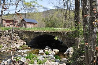
Plunketts Creek Bridge No. 3 was a rubble masonry stone arch bridge over Plunketts Creek in Plunketts Creek Township, Lycoming County in the U.S. state of Pennsylvania. It was built between 1840 and 1875, probably closer to 1840, when the road along the creek between the unincorporated villages of Barbours and Proctor was constructed. Going upstream from the mouth, the bridge was the third to cross the creek, hence its name.

The Coombs Covered Bridge is a wooden covered bridge which carries Coombs Bridge Road over the Ashuelot River in northern Winchester, New Hampshire. It was built in 1837, and is one of the state's small number of surviving 19th-century covered bridges. It was listed on the National Register of Historic Places in 1976.

The Ashuelot Covered Bridge is a historic wooden covered bridge over the Ashuelot River on Bolton Road, just south of its intersection with NH 119 in Ashuelot, an unincorporated village of Winchester, New Hampshire. Built in 1864-65, it is one of the state's few surviving 19th-century covered bridges. It was listed on the National Register of Historic Places in 1981.

The Mill Street Stone Arch Bridge is located on that street in Pine Hill, New York, United States. It is a small bridge over a local creek built around the turn of the 20th century. It is one of two stone arch bridges in the former village built by local stonemason Matthew G. Thompson. It has remained intact and in use since then, and was listed on the National Register of Historic Places in 1996. It is located in the Pine Hill Historic District.

Fort William Henry is located in the village of New Harbor in the town of Bristol, Maine. The fort was, in its time, the largest in New England. The fort was originally built in 1692 but destroyed four years later by New France in the Siege of Pemaquid (1696). A reconstruction was built in 1908. The fort was added to the National Register of Historic Places on December 1, 1969. Fort William Henry is now operated as a museum about the fort's history.

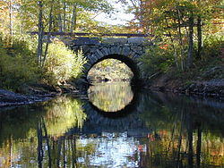
The East Putney Brook Stone Arch Bridge is a historic stone arch bridge in eastern Putney, Vermont. Built in 1902, it is a rare statewide example of a 20th-century stone bridge, and one of a number of such area bridges built by Townshend farmer and mason James Otis Follett. It was listed on the U.S. National Register of Historic Places in 1976. The bridge is located just west (upstream) of the present alignment of River Road, which it formerly carried.

The Stone Arch Underpass is a historic stone arch bridge spanning Glen Road in Lebanon, New Hampshire. Built about 1848, it carried the Boston and Maine Railroad's former Northern Line. It is one of a small number of 19th-century stone arch bridges in the state, and the only one known in central western New Hampshire. The bridge was listed on the National Register of Historic Places in 1985. The railroad right-of-way has been functionally abandoned, and the bridge may become part of a continuation of the Northern Rail Trail.

The Newichawannock Canal is a man-made canal which drains Great East Lake into Horn Pond at the border between Wakefield, New Hampshire, and Acton, Maine, in the northeastern United States. It is at the head of the Salmon Falls River, which the Abenaki called Newichawannock, meaning "river with many falls". Begun in 1850 by the Great Falls Company to increase the water available for its mills in Somersworth, New Hampshire, the 0.75-mile (1.21 km) canal is unusual as it was built for strictly industrial purposes in an area remote from the actual industrial site. The canal forms the boundary between the states of New Hampshire and Maine, and is spanned by a stone bridge built at the same time. The canal and bridge, along with related artifacts, were listed on the National Register of Historic Places in 2014.

The Porter-Parsonsfield Bridge is a covered bridge in western Maine, and one of the few 19th-century covered bridges left in the state. The bridge spans the Ossipee River just east of the modern alignment of North Road, which it formerly carried, between the towns of Porter and Parsonsfield. Built in 1876 by the towns, it is a Paddleford truss bridge which has been strengthened with laminated arches. The bridge was closed to traffic in 1960, and is now maintained by the state. It was listed on the National Register of Historic Places in 1970.

The Follett Stone Arch Bridge Historic District encompasses a group of four stone arch bridges in southwestern Townshend, Vermont. All four bridges were built by James Otis Follett, a local self-taught mason, between 1894 and 1910, and represent the single greatest concentration of surviving bridges he built. The district was listed on the National Register of Historic Places in 1976.
The Simpsonville Stone Arch Bridge is a historic stone arch bridge, carrying Vermont Route 35 across Simpson Brook, north of the village of Townshend, Vermont. Built about 1909, it is one of a few surviving bridges in the region built by local mason James Otis Follett. It was listed on the National Register of Historic Places in 1977.

The West Townshend Stone Arch Bridge carries Round Hill Road across Tannery Brook in the village of West Townshend, Vermont. Built about 1910, it is one of the few surviving bridges of a group built by local mason James Otis Follett in the early 20th century. It was listed on the National Register of Historic Places in 1977.

The Quechee Gorge Bridge is a historic bridge, carrying U.S. Route 4 (US 4) across Quechee Gorge, near the Quechee village of Hartford, Vermont. Built in 1911, it is Vermont's oldest surviving steel arch bridge. It was listed on the National Register of Historic Places in 1990.

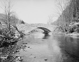
The Skilton Road Bridge is a historic stone arch bridge, carrying Skilton Road across the Nonewaug River in northwestern Watertown, Connecticut. The bridge was built in 1865-66, and is a rare well-preserved example of a mid-19th century stone bridge. It was listed on the National Register of Historic Places in 1991.

The Mill Brook Bridge is a historic stone arch bridge, located just north of Lower Blissville Road in Lisbon, Connecticut. With a plausibly estimated construction date of the 1790s, it is probably the oldest surviving stone arch bridge in the state. It was listed on the National Register of Historic Places in 1997. Since then, it has deteriorated and is partially collapsed.