Related Research Articles

The Arkansas Post, formally the Arkansas Post National Memorial, was the first European settlement in the Mississippi Alluvial Plain and present-day U.S. state of Arkansas. In 1686, Henri de Tonti established it on behalf of Louis XIV of France for the purpose of trading with the Quapaw Nation. The French, Spanish, and Americans, who acquired the territory in 1803 with the Louisiana Purchase, considered the site of strategic value. It was the capital of Arkansas from 1819 until 1821 when the territorial government relocated to Little Rock.

The National Register of Historic Places in the United States is a register including buildings, sites, structures, districts, and objects. The Register automatically includes all National Historic Landmarks as well as all historic areas administered by the U.S. National Park Service. Since its introduction in 1966, more than 90,000 separate listings have been added to the register.

The Nodena site is an archeological site east of Wilson, Arkansas, and northeast of Reverie, Tennessee, in Mississippi County, Arkansas, United States. Around 1400–1650 CE an aboriginal palisaded village existed in the Nodena area on a meander bend of the Mississippi River. The Nodena site was discovered and first documented by Dr. James K. Hampson, archaeologist and owner of the plantation on which the Nodena site is located. Artifacts from this site are on display in the Hampson Museum State Park in Wilson, Arkansas. The Nodena site is the type site for the Nodena phase, believed by many archaeologists to be the province of Pacaha visited by Spanish explorer Hernando de Soto in 1542.

The Eaker site (3MS105) is an archaeological site on Eaker Air Force Base near Blytheville, Arkansas, that was declared a National Historic Landmark in 1996. The site is the largest and most intact Late Mississippian Nodena phase village site within the Central Mississippi Valley, with archaeological evidence indicating a palisaded village some 50 acres (20 ha) in size, with hundreds of structures. The site's major period of occupation was 1350–1450 CE, although evidence of occupation dates back to 600 CE. The site is also hypothesized to have been occupied by the Quapaw prior to a migration further south, after which they made contact with Europeans in the late 17th century.

The Menard–Hodges site (3AR4), is an archaeological site in Arkansas County, Arkansas. It includes two large platform mounds as well as several house mounds. It is the type site for the Menard phase, a protohistoric Mississippian culture group.
Parkin Archeological State Park, also known as Parkin Indian Mound, is an archeological site and state park in Parkin, Cross County, Arkansas. Around 1350–1650 CE an aboriginal palisaded village existed at the site, at the confluence of the St. Francis and Tyronza rivers. Artifacts from this site are on display at the site museum. The Parkin site is the type site for the Parkin phase, an expression of the Mississippian culture from the Late Mississippian period. Many archeologists believe it to be part of the province of Casqui, documented as visited by Spanish explorer Hernando de Soto in 1542. Archeological artifacts from the village of the Parkin people are dated to 1400–1650 CE.
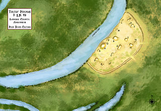
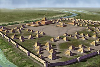
Plum Bayou Mounds Archeological State Park, formerly known as "Toltec Mounds Archeological State Park", also known as Knapp Mounds, Toltec Mounds or Toltec Mounds site, is an archaeological site from the Late Woodland period in Arkansas that protects an 18-mound complex with the tallest surviving prehistoric mounds in Arkansas. The site is on the banks of Mound Lake, an oxbow lake of the Arkansas River. It was occupied by its original inhabitants from the 7th to the 11th century. The site is designated as a National Historic Landmark.

Hampson Archeological Museum State Park is a 5-acre (2.0 ha) Arkansas state park in Mississippi County, Arkansas in the United States. The museum contains a collection of archeological artifacts from the Nodena site, which is a former Native American village on the Mississippi River between 1400 and 1650. James K. Hampson began excavating the site in the 1920s, a museum was built in 1946 and the Arkansas General Assembly officially accepted the collection of artifacts from the Hampson family on March 30, 1957. The park first opened in 1961 as Hampson Museum State Park and has since been renamed.

This is a list of the National Register of Historic Places listings in Cross County, Arkansas.

This is a list of the National Register of Historic Places listings in Hempstead County, Arkansas.

The Petroglyph Point is an archaeological site within the Lava Beds National Monument, located southeast of Tulelake, California. Petroglyph Point contains one of the largest panels of Native American rock art in the United States. The petroglyphs are carved along the face of a former island of ancient Tule Lake, in a region historically of the Modoc people territory. The Petroglyph Point Archeological Site was listed on the National Register of Historic Places in 1975, while the Lava Beds National Monument Archeological District was listed in March 1991.
The Hughes Mound Site, (3SA11), is an archeological site in Saline County, Arkansas near Benton. The 4.5-acre (1.8 ha) is an important Caddoan Mississippian culture village center, at the northeastern frontier of that civilization. It is the only known platform mound site south of Benton on the Saline River. The site has not been dated, but artifacts found there are consistent with the Caddoan period; no contact-period artifacts have been found.

Boone's Mounds are a ceremonial site of the Coles Creek culture located in Calhoun County, Arkansas. The site is one of the largest mound sites in the Ouachita River valley. Archeological excavation at the site has yielded dates of occupation as early as 600 AD, and it may still have been in use during the early contact period, c. 1700. The site was located on private property at the time of its listing on the National Register of Historic Places in 1980.

The Bellows Falls Petroglyph Site is an archaeological site containing panels of precontact Native American petroglyphs in Bellows Falls, Vermont. Located near the Vilas Bridge on bedrock west of and above the Connecticut River, adjacent to Great Falls, they depict a rarely-seen assemblage of anthropomorphic figures that is believed to be unique in New England, and uncommon even in surrounding geographic areas. The site was listed on the National Register of Historic Places in 1990.

Gadao's Cave, also known as Liyang Gadao, is a rock art site on the United States island of Guam. Located near the village of Inarajan, the cave is the site of a panel of approximately 50 Chamorro pictographs, painted with a mixture of coral lime and tree sap. The most unusual images are of two human stick figures that appear to be carrying things. It is not known who painted them or when, and what their significance is. The legendary chief of Inarajan Gadao is believed to be the creator of the cave's images.
Archeological Site 3NW79 is a prehistoric pictograph site in the Ozark-St. Francis National Forest, in Newton County, Arkansas. It consists of a panel of twenty figures, set in a sheltered area. It is expected to contribute to the understanding of Mississippian cultures that lived in the area c. 1000-1500 CE.
The Edgemont Shelter, also designated by the Smithsonian trinomial 3VB6, is a prehistoric rock art site in Van Buren County, Arkansas. Located on a bluff overlooking Greers Ferry Lake, it consists of a panel extensively painted with petroglyphs. The site has been dated to about 1500.
Archeological Site 3PP141 is a prehistoric rock art site in Pope County, Arkansas. The art at the site, which is on state-owned land, is believed to have been painted during the period of the Mississippian culture. The 28 drawings at this site are part of a larger collection within the state that are expected to improve the understanding of Mississippian religious practices during that time.
Archeological Site 3PP142 is a prehistoric rock art site in Pope County, Arkansas. The art at the site, which is on state-owned land, is believed to have been painted during the period of the Mississippian culture. The 11 drawings at this site are part of a larger collection within the state that are expected to improve the understanding of Mississippian religious practices during that time.
Archeological Site 3PP144 is a prehistoric rock art site in Pope County, Arkansas. The art at the site, which is Ozark-St. Francis National Forest, consists two drawings in black pigment, of unknown age. This site are part of a larger collection within the state that are expected to improve the understanding of how rock art in the Ozark Mountains region was made, and for what purpose.
References
- 1 2 "National Register Information System". National Register of Historic Places . National Park Service. July 9, 2010.
- ↑ "Summary description of Archeological Site 3YE958". Arkansas Preservation. Retrieved April 20, 2016.
| Topics | |
|---|---|
| Lists by state |
|
| Lists by insular areas | |
| Lists by associated state | |
| Other areas | |
| Related | |
| | This article about a property in Yell County, Arkansas on the National Register of Historic Places is a stub. You can help Wikipedia by expanding it. |