Related Research Articles

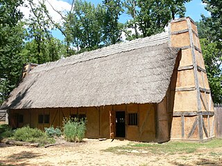
The Jamestown settlement in the Colony of Virginia was the first permanent English settlement in the Americas. It was located on the northeast bank of the James River, about 2.5 mi (4 km) southwest of the center of modern Williamsburg. It was established by the Virginia Company of London as "James Fort" on May 4, 1607 O.S., and was considered permanent after a brief abandonment in 1610. It followed several failed attempts, including the Lost Colony of Roanoke, established in 1585 on Roanoke Island, later part of North Carolina. Jamestown served as the colonial capital from 1616 until 1699. Despite the dispatch of more settlers and supplies, more than 80 percent of the colonists died in 1609–10, mostly from starvation and disease. In mid-1610, the survivors abandoned Jamestown, though they returned after meeting a resupply convoy in the James River.

James City County is a county located in the Commonwealth of Virginia. As of the 2020 census, the population was 78,254. Although politically separate from the county, the county seat is the adjacent independent city of Williamsburg.

Jamestown Island is a 1,561-acre island in the James River in Virginia, part of James City County. It is located off Glasshouse Point, to which it is connected via a causeway to the Colonial Parkway. Much of the island is wetland, including both swamp and marsh.
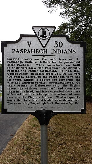
The Paspahegh tribe was a Native American tributary to the Powhatan paramount chiefdom, incorporated into the chiefdom around 1596 or 1597. The Paspahegh Indian tribe lived in present-day Charles City and James City counties, Virginia. The Powhatan Confederacy included Indigenous peoples of the Northeastern Woodlands who spoke a related Eastern Algonquian languages.
The "Citie of Henricus"—also known as Henricopolis, Henrico Town or Henrico—was a settlement in Virginia founded by Sir Thomas Dale in 1611 as an alternative to the swampy and dangerous area around the original English settlement at Jamestown, Virginia. It was named for Henry, Prince of Wales (1594–1612), the eldest son of King James I.

Werowocomoco was a village that served as the headquarters of Chief Powhatan, a Virginia Algonquian political and spiritual leader when the English founded Jamestown in 1607. The name Werowocomoco comes from the Powhatan werowans (weroance), meaning "leader" in English; and komakah (-comoco), "settlement". The town was documented by English settlers in 1608 as located near the north bank of the York River in what is now Gloucester County. It was separated by that river and the narrow Virginia Peninsula from the English settlement of Jamestown, located on the James River.
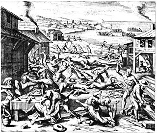
The Anglo–Powhatan Wars were three wars fought between settlers of the Virginia Colony and Algonquin Indians of the Powhatan Confederacy in the early 17th century. The first war started in 1609 and ended in a peace settlement in 1614. The second war lasted from 1622 to 1632. The third war lasted from 1644 until 1646 and ended when Opechancanough was captured and killed. That war resulted in a defined boundary between the Indians and colonial lands that could only be crossed for official business with a special pass. This situation lasted until 1677 and the Treaty of Middle Plantation which established Indian reservations following Bacon's Rebellion.

Jordan Point is a small unincorporated community on the south bank of the James River in the northern portion of Prince George County, Virginia, United States. It is about 20 miles from Richmond and 30 miles upstream from Jamestown on the James River. It was the location of extensive archeological research between 1987 and 1993. This research provided substantial information about human existence in the area from the prehistoric to the late colonial eras. In particular, the research extensively studied the Jordan's Journey settlement that existed between 1620 and 1640 during early years of the Virginia colony.
Falling Creek Ironworks was the first iron production facility in North America. It was established by the Virginia Company of London in Henrico Cittie (sic) on Falling Creek near its confluence with the James River. It was short-lived due to an attack by Native Americans in 1622.


The Eaker site (3MS105) is an archaeological site on Eaker Air Force Base near Blytheville, Arkansas, that was declared a National Historic Landmark in 1996. The site is the largest and most intact Late Mississippian Nodena phase village site within the Central Mississippi Valley, with archaeological evidence indicating a palisaded village some 50 acres (20 ha) in size, with hundreds of structures. The site's major period of occupation was 1350–1450 CE, although evidence of occupation dates back to 600 CE. The site is also hypothesized to have been occupied by the Quapaw prior to a migration further south, after which they made contact with Europeans in the late 17th century.

The Menard–Hodges site (3AR4), is an archaeological site in Arkansas County, Arkansas. It includes two large platform mounds as well as several house mounds. It is the type site for the Menard phase, a protohistoric Mississippian culture group.
Nady is an unincorporated community in Arkansas County, Arkansas, United States. It is the location of a National Historic Landmark, the Menard–Hodges site. The environs of Nady, at the southern tip of the Little Prairie, are in the portion of Arkansas that saw the earliest European settlement in what is now the state of Arkansas, including Tonty’s 1686 post. The Menard-Hodges archeological site, about one-half mile southwest of Wallace-Menard-Coose Cemetery, along with the adjacent Wallace Bottom archeological site, appear to be the locations of the late 1600s Quapaw village of Osotouy, Tonty’s 1686 Post, and the early to mid-1700s French Arkansas Post.
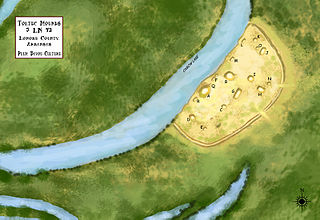
Plum Bayou Mounds Archeological State Park, formerly known as "Toltec Mounds Archeological State Park", also known as Knapp Mounds, Toltec Mounds or Toltec Mounds site, is an archaeological site from the Late Woodland period in Arkansas that protects an 18-mound complex with the tallest surviving prehistoric mounds in Arkansas. The site is on the banks of Mound Lake, an oxbow lake of the Arkansas River. It was occupied by its original inhabitants from the 7th to the 11th century. The site is designated as a National Historic Landmark.
Captain Samuel Mathews was a Virginia planter, political figure, and the father of Governor Samuel Mathews.

Kentland Farm Historic and Archeological District is a historic home, archaeological site, and national historic district located near Blacksburg, Montgomery County, Virginia. The district encompasses a complex of 19th century agricultural outbuildings associated with a Federal and Greek Revival style brick dwelling built 1834–1835. Located in the district are significant archaeological resources that include a complex of Late Woodland village or camp sites.

Fort Mattapony/Ryefield is a historic archaeological site located near Walkerton, King and Queen County, Virginia. The Fort Mattapony/Ryefield archeological sites, which has been dated archeologically to the fourth quarter of the 17th century, are located in a one-acre area on prominent grassy hilltop overlooking the Mattaponi River, Walkerton and Locust Grove. Collectively designated 44KQ7 in Virginia's official inventory of archeological sites, the site consists of two closely associated components, the Fort Mattapony storehouse and a domestic structure called Ryefield. After abandonment of the fort at the close of the 17th century and the domestic structure by the mid-18th century, a later colonial plantation, Locust Grove, developed in the surrounding area, which continues to be occupied by descendants.
The Basses Choice/Days Point Archeological District is a large area of coastal Isle of Wight County, Virginia, that is of archaeological interest. It is located in the area between the Pagan River and the James River, north of Smithfield. The point of land at the confluence of the two rivers has been known as Day's Point since Virginia was settled by English colonists in the 17th century. Land on the point was granted to Captain John Day, and the area was known as Warrosquyoake Shire before it was renamed Isle of Wight County. In 1621 Nathaniel Basse was granted land that bordered Pagan Bay. Basse settled colonists on this land in 1622. His house was burned in the Great Massacre of 1622, when a significant number of settlers in Warrosquyoake were killed by Native Americans. Basse's settlement was rebuilt, and he was reported as owning 300 acres (120 ha) in 1625.

The Swann's Point Plantation Site is an archaeological site near the James River in Surry County, Virginia. The Swann's Point area, located west of the mouth of Gray Creek, has a rich historic of precolonial Native American occupation, as well as significant early colonial settlements. It was first granted to Richard Pace, whose warning famously saved the Jamestown Colony during the Indian Massacre of 1622. The Paces abandoned their settlement in 1624.
References
- 1 2 "National Register Information System". National Register of Historic Places . National Park Service. July 9, 2010.
- ↑ "Virginia Landmarks Register". Virginia Department of Historic Resources. Archived from the original on September 21, 2013. Retrieved May 12, 2013.
- ↑ The Governor's Land at Two Rivers: History
- ↑ "Paspahegh", Virtual Jamestown, accessed 19 Apr 2010
- ↑ "Paspahegh Archaeology: Data Recovery Investigations of Site 44JC308 at the Governor's Land at Two Rivers, James City County, Virginia," ed. Mary Ellen Hodges and Charles Hodges, JRIA, 1994
